METAR & TAF KMEI
Current METAR
Observed 15:58Z
KMEI 271558Z 00000KT 10SM CLR 32/24 A2996 RMK AO2 SLP142 T03220239
- Wind
- 000° @ 0 kt
- Visibility
- 10 SM
- Temp / Dew
- 32°C / 24°C
- Altimeter
- 29.96 inHg
- Clouds
- CLR
- Density alt
- 2,360 ft
- Ceiling
- Unlimited
- Rules
- VFR
Airport info & contacts
Manager on record, flight service, ARTCC, attendance schedule and pattern altitude — published by the FAA and refreshed every 28 days.
Location
- From city
- 3 NM SW
- VFR sectional
- MEMPHIS
- ARTCC
- ZME · MEMPHIS
- NOTAM facility
- MEI (NOTAM-D)
Airport manager
- Name
- TOM WILLIAMS
- Phone
- 601-482-0364
- Address
- 2811A AIRPORT BLVD, MERIDIAN MS 39307
Flight service · Hours
- FSS GWO
- GREENWOOD1-800-WX-BRIEF
- Attendance
- 0600-2200
Frequencies
Tap any row to copy the frequency to your clipboard.
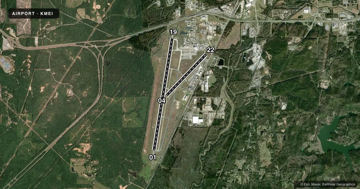
Runways & pattern
Full pagePattern entry · RWY 01
LEFT TRAFFIC| Runway | Heading (°M) | Length | Surface | Traffic |
|---|---|---|---|---|
| 01/19 | 7° / 187° | 10,003 ft | ASPH-CONC | Standard L |
| 04/22 | 42° / 222° | 5,052 ft | ASPH | Standard L |
Runway end performance
| End | TORA | TODA | ASDA | LDA | VGSI | Approach lights | Obstruction |
|---|---|---|---|---|---|---|---|
| 01 | 10,003' | 10,003' | 10,003' | 9,013' | PAPI 4-box left(3°) | MALSR | — |
| 19 | 10,003' | 10,003' | 10,003' | 9,013' | PAPI 4-box left(3°) | MALSR | — |
| 04 | 5,052' | 5,052' | 5,052' | 5,052' | PAPI 2-box left(3.13°) | — | 86', trees, 1926' from thr, 444' R of cntrln, slope 20 |
| 22 | 5,052' | 5,052' | 5,052' | 5,052' | PAPI 2-box left(3°) | — | 35', pole, 1125' from thr, 390' R of cntrln, slope 26 |
Declared distances in feet. TORA = takeoff run available, TODA = takeoff distance, ASDA = accelerate-stop, LDA = landing distance.
Airport sketch
Runways drawn to scale from FAA survey coordinates, rendered over satellite imagery. Not for navigation.
Approaches & charts
ILS · 2
Services on the field
Fuel grades, oxygen, maintenance, ramp storage and lighting — as declared to the FAA by the airport operator.
Fuel & services
- Fuel
- 100LLAA++
- Oxygen (bulk)
- HIGH/LOW
- Airframe repair
- Major
- Power plant repair
- Major
- Other services
- AMB,AVNCS,CARGO,CHTR,INSTR,RNTL
Ramp & ground
- Transient storage
- Tie-down
- Hangar
- Landing fee
- No fee published
- Customs
- Not available
- Lighting schedule
- SEE RMK
- Beacon schedule
- SS-SR
- Beacon
- White / Green (civil land)(WG)
- Wind indicator
- Lighted
- Segmented circle
- Yes
Fuel & FBOs
Cheapest 100LL and Jet A on the field and nearby. Always confirm with the FBO before taxi.
Airport notes
Surface conditions, obstructions, local procedures, lighting outages and other notes published with each FAA cycle.
General notes
- ANG ATNDD 0700-1630 MON-FRI EXCP HOLS.
- ANG LTD PRKG USE; RSC INFO AVBL FOR ANG OPS DURG NML DUTY HRS. ALL TRAN ACFT 48 HR PPR. OBO.
- ANG RAMP CLSD EXC PPR, 601-484-9734/9714. ARNG DSN 293-2829 C601-696-8829.
- BASH PHASE II PERIOD MAR-MAY, SEP-NOV. CTC AFLD MGMT OR COMD POST FOR CURRENT BIRD WATCH COND.
- ANG PROVIDES ATC SERVICES AT KMEI.
- FOR CD CTC MEMPHIS ARTCC AT 901-368-8453/8449.
Lighting notes
- ACTVT MALSR RWY 01 & 19; MIRL RWY 04/22; HIRL RWY 01/19; TWY LGTS - CTAF.
Runway surface & condition
- 01/19PCR VALUE: 730/F/C/W/U
- 04/22PCR VALUE: 120/F/C/W/U
- 01/19NON-STD RESA DUE TO SFC VARNS.
Other notes
- THIS AIRPORT HAS BEEN SURVEYED BY THE NATIONAL GEODETIC SURVEY.
- 1FOR ATTENDANT AFT HRS CALL 601-693-7282.
- 01/19DTHR CONC.
VFR map & nearby airports
VFR sectional. Tap any ICAO chip to open that airport.
Key facts · KMEI
Answer card- ICAO
- KMEI
- Name
- KEY FLD
- Location
- MERIDIAN, MISSISSIPPI
- Elevation
- 297.8 ft MSL
- Traffic pattern altitude
- 1,297.8 ft MSL (1,000 AGL)
- Control tower
- Towered · 0600-2200, OTR TIMES BY NOTAM
- Total runways
- 2
- Longest runway
- 01/19 · 10,003 ft
- Published ILS approaches
- 2
- Published frequencies
- 14
- Magnetic variation
- 2°
- Current flight rules
- VFR
- Current wind
- 000° at 0 kt
- Favored runway now
- –
Key Field sits in Meridian, Mississippi. The field elevation is 297.8 ft MSL. It has two runways. The longest is 01/19 at 10,003 ft. The airport is towered. Tower hours are 0600 to 2200, with other times by NOTAM. The Air National Guard also provides air traffic control services at KMEI.
Runway 01 and 19 have ILS approaches. Runway 01/19 has MALSR lighting. Runway 04/22 has medium intensity runway lights. Taxiway lights are controlled by CTAF. Pattern altitude is not published in the facts. Use the current FAA Chart Supplement for the published pattern entry and any local procedures before you go.
Meridian Aviation is on the field. It carries 100LL and Jet A Prist. For after-hours attendant service, the published remarks list a phone number. BASH Phase II runs March through May and September through November. Contact airfield management or the command post for current bird watch conditions. Runway 01/19 also has a displaced concrete threshold and non-standard runway end safety areas. That matters if you are planning a heavy arrival or a short-field departure. Transient aircraft also need 48 hour prior permission to operate or overfly. Check with the airport operator before you launch.