METAR & TAF KMAF
Current METAR
Observed 20:53Z
KMAF 272053Z 15010G19KT 9SM CLR 37/13 A2993 RMK AO2 SLP080 T03720133 56017 $
- Wind
- 150° @ 10G19 kt
- Visibility
- 9 SM
- Temp / Dew
- 37°C / 13°C
- Altimeter
- 29.93 inHg
- Clouds
- CLR
- Density alt
- 6,189 ft
- Ceiling
- Unlimited
- Rules
- VFR
Airport info & contacts
Manager on record, flight service, ARTCC, attendance schedule and pattern altitude — published by the FAA and refreshed every 28 days.
Location
- From city
- 8 NM SW
- VFR sectional
- SAN ANTONIO
- ARTCC
- ZFW · FORT WORTH
- NOTAM facility
- MAF (NOTAM-D)
Airport manager
- Name
- JUSTINE RUFF
- Phone
- 432-560-2200
- Address
- PO BOX 60305, MIDLAND TX 79711
Flight service · Hours
- FSS SJT
- SAN ANGELO1-800-WX-BRIEF
- Attendance
- ALL
Frequencies
Tap any row to copy the frequency to your clipboard.
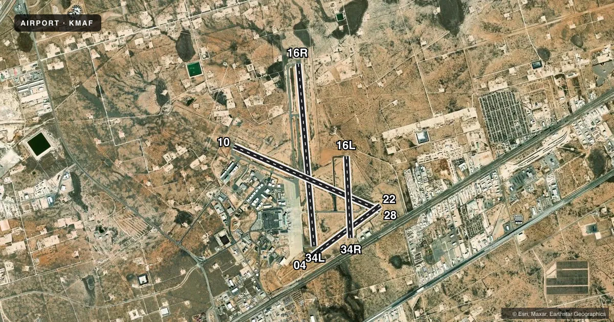
Runways & pattern
Full pagePattern entry · RWY 16R
LEFT TRAFFIC| Runway | Heading (°M) | Length | Surface | Traffic |
|---|---|---|---|---|
| 16R/34LFavored | 166° / 346° | 9,501 ft | ASPH | Standard L |
| 10/28 | 105° / 285° | 8,302 ft | ASPH | Standard L |
| 04/22 | 45° / 225° | 4,605 ft | ASPH | Standard L |
| 16L/34R | 168° / 348° | 4,247 ft | ASPH | Standard L |
Runway end performance
| End | TORA | TODA | ASDA | LDA | VGSI | Approach lights | Obstruction |
|---|---|---|---|---|---|---|---|
| 16R | 9,501' | 9,501' | 9,501' | 9,501' | PAPI 4-box left(3°) | — | — |
| 34L | 9,501' | 9,501' | 9,501' | 9,501' | PAPI 4-box left(3°) | — | 28', pole, 1550' from thr, 300' R of cntrln, slope 48 |
| 10 | 8,302' | 8,302' | 8,177' | 8,177' | PAPI 4-box left(3°) | MALSR | — |
| 28 | 8,302' | 8,302' | 8,302' | 7,610' | PAPI 4-box right(3°) | MALS | — |
| 04 | 4,605' | 4,605' | 4,605' | 4,605' | — | — | 57', pole, 2688' from thr, 390' R of cntrln, slope 43 |
| 22 | 4,605' | 4,605' | 4,605' | 4,605' | — | — | 23', road, 1333' from thr, 9' R of cntrln, slope 49 |
| 16L | 4,247' | 4,247' | 4,247' | 4,247' | — | — | 7', fence, 375' from thr, 100' R of cntrln, slope 25 |
| 34R | 4,247' | 4,247' | 4,247' | 4,247' | — | — | 13', road, 390' from thr, 250' R of cntrln, slope 14 |
Declared distances in feet. TORA = takeoff run available, TODA = takeoff distance, ASDA = accelerate-stop, LDA = landing distance.
Airport sketch
Runways drawn to scale from FAA survey coordinates, rendered over satellite imagery. Not for navigation.
Approaches & charts
ILS · 1
Services on the field
Fuel grades, oxygen, maintenance, ramp storage and lighting — as declared to the FAA by the airport operator.
Fuel & services
- Fuel
- 100LLAA1
- Oxygen (bottled)
- Low pressure
- Oxygen (bulk)
- Low pressure
- Airframe repair
- Major
- Power plant repair
- Major
- Other services
- AFRT,AMB,AVNCS,CARGO,CHTR,INSTR,RNTL,SALES
Ramp & ground
- Transient storage
- Tie-down
- Hangar
- Landing fee
- Yes
- Customs
- Not available
- Lighting schedule
- SEE RMK
- Beacon schedule
- SS-SR
- Beacon
- White / Green (civil land)(WG)
- Wind indicator
- Lighted
- Segmented circle
- Yes
Fuel & FBOs
Cheapest 100LL and Jet A on the field and nearby. Always confirm with the FBO before taxi.
Airport notes
Surface conditions, obstructions, local procedures, lighting outages and other notes published with each FAA cycle.
General notes
- RWYS 04/22 & 16L/34R CLSD TO ACFT OVER 60000 LBS.
- TWYS B & F NORTH RWY 10/28 CLSD TO ACFT OVER 60000 LBS.
- BIRD ACTIVITY ON & INVOF ARPT.
- NMRS OIL RIGS INVOF ARPT AT OR BLW 200 FT AGL.
- ALL RUNUP PADS ARE LTD USAGE TO ACFT 60000 LBS OR BLW.
- FOR CD IF UNA TO CTC ON FSS FREQ, CTC FORT WORTH ARTCC AT 817-858-7584.
- OPRS ON NON PAVED SFC ARE PROHIBITED WO 24 HR PPR.
Lighting notes
- ATC CTL. WHEN ATCT CLSD HIRL RWYS 10/28 & 16R/34L PRESET ON LOW INTST. WHEN ATCT CLSD ACTVT MALSR RWY 10; MALS RWY 28; MIRL RWYS 04/22 & 16L/34R - CTAF.
Runway surface & condition
- 10/28PCR VALUE: 660/F/B/X/T
- 16R/34LPCR VALUE: 730/F/B/X/T
- 04/22RWY 04/22 NOT AVBL FOR PART 121/PART 380 OPS WITH SKED PAX CARRYING OPS MORE THAN 9 PAX SEATS AND NON-SKED PAX CARRYING OPS MORE THAN 30 PAX SEATS.
- 10/28180 DEG TURN PROHIBITED TO ACFT 60000 LBS OR ABV.
- 16L/34RRWY 16L/34R NOT AVBL FOR PART 121/PART 380 OPS WITH SKED PAX CARRYING OPS MORE THAN 9 PAX SEATS AND NON-SKED PAX CARRYING OPS MORE THAN 30 PAX SEATS.
- 16R/34L180 DEG TURN PROHIBITED TO ACFT 60000 LBS OR ABV.
- 10/28EAST 692 FT CLSD TO ACFT OVER 60000 LBS.
Other notes
- THIS AIRPORT HAS BEEN SURVEYED BY THE NATIONAL GEODETIC SURVEY.
- FOR ARFF SVC BTN 0000-0600 DLY CTC FSS AT 800-992-7433.
VFR map & nearby airports
VFR sectional. Tap any ICAO chip to open that airport.
Key facts · KMAF
Answer card- ICAO
- KMAF
- Name
- MIDLAND INTL AIR AND SPACE PORT
- Location
- MIDLAND, TEXAS
- Elevation
- 2,872.1 ft MSL
- Traffic pattern altitude
- 3,872.1 ft MSL (1,000 AGL)
- Control tower
- Towered · 0600-0000
- Total runways
- 4
- Longest runway
- 16R/34L · 9,501 ft
- Published ILS approaches
- 1
- Published frequencies
- 20
- Magnetic variation
- 9°
- Current flight rules
- VFR
- Current wind
- 150° at 10 kt
- Favored runway now
- RWY 16R
Midland Intl Air and Space Port sits in Midland, Texas at 2,872.1 ft MSL. It has four asphalt runways. The longest is 16R/34L at 9,501 ft. The field is towered from 0600 to 0000. One ILS is published for runway 10. Pattern altitude is not published, so use the standard 1,000 ft AGL for light piston traffic unless ATC or the current FAA Chart Supplement says otherwise.
This is a Class C field. Expect busy commercial traffic and coordinated taxi instructions. Signature Aviation is on the field. It carries 100LL and Jet A. The airport remarks matter here. Runways 04/22 and 16L/34R are closed to aircraft over 60,000 pounds. Taxiways B and F north of runway 10/28 are also closed to aircraft over 60,000 pounds. If you are in a heavy aircraft, check the current Chart Supplement before you go.
The airport also has bird activity in and around the field. Numerous oil rigs are nearby at or below 200 ft AGL. That is worth keeping in mind on departure and arrival. When the tower is closed, lighting is preset for the main runways and some lights are activated by CTAF. For any current noise, curfew, or special operating limits, verify the current FAA Chart Supplement or call the airport operator or FBO directly before departure.