METAR & TAF KLHW
Current METAR
Observed 13:55Z
KLHW 271355Z 03004KT 10SM CLR 28/24 A2990 RMK SLP114 WIND DATA ESTMD ALSTG ESMTD
- Wind
- 030° @ 4 kt
- Visibility
- 10 SM
- Temp / Dew
- 28°C / 24°C
- Altimeter
- 29.90 inHg
- Clouds
- CLR
- Density alt
- 1,643 ft
- Ceiling
- Unlimited
- Rules
- VFR
Airport info & contacts
Manager on record, flight service, ARTCC, attendance schedule and pattern altitude — published by the FAA and refreshed every 28 days.
Location
- VFR sectional
- JACKSONVILLE
- ARTCC
- ZJX · JACKSONVILLE
- NOTAM facility
- LHW (NOTAM-D)
Airport manager
- Name
- JESSE WILLETT
- Phone
- (912) 435-3130
- Address
- 1116 E. LOWE CIRCLE, HINESVILLE GA 31315
Flight service · Hours
- FSS MCN
- MACON1-800-WX-BRIEF
- Attendance
- MON-FRI · 0600-2300
Frequencies
Tap any row to copy the frequency to your clipboard.
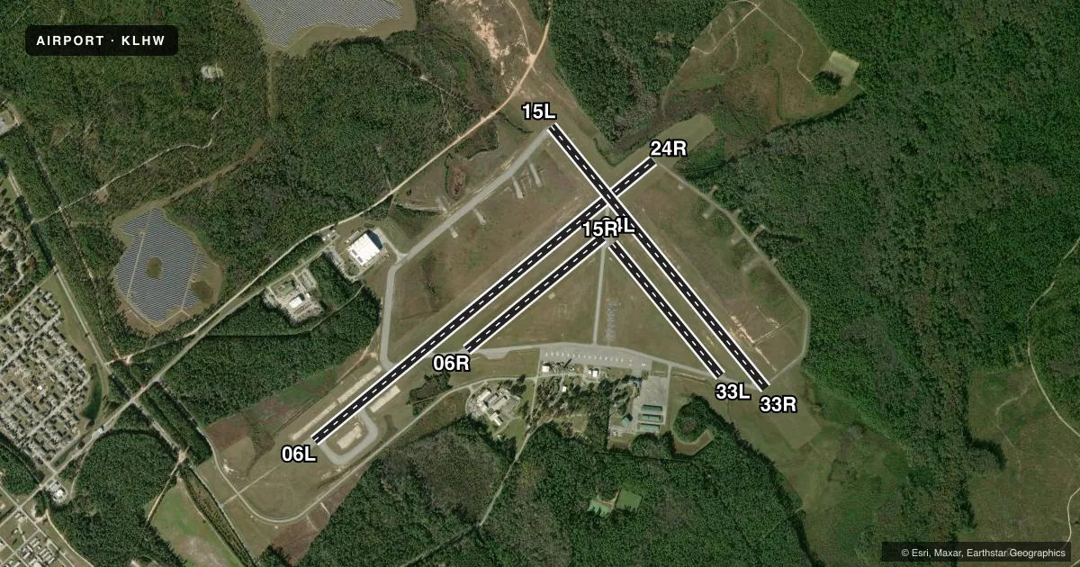
Runways & pattern
Full pagePattern entry · RWY 06L
RIGHT TRAFFIC| Runway | Heading (°M) | Length | Surface | Traffic |
|---|---|---|---|---|
| 06L/24RFavored | 47° / 227° | 6,500 ft | ASPH | 06L R |
| 15L/33R | 137° / 317° | 5,001 ft | ASPH | Standard L |
| 06R/24L | 47° / 227° | 2,610 ft | ASPH | Standard L |
| 15R/33L | 137° / 317° | 2,520 ft | ASPH | Standard L |
Runway end performance
| End | TORA | TODA | ASDA | LDA | VGSI | Approach lights | Obstruction |
|---|---|---|---|---|---|---|---|
| 06L | — | — | — | — | PAPI 4-box left(3°) | — | 113', trees, 2745' from thr, 610' R of cntrln, slope 22 |
| 33R | — | — | — | — | PAPI 4-box left(3°) | — | 81', trees, 2438' from thr, 551' R of cntrln, slope 27 |
Declared distances in feet. TORA = takeoff run available, TODA = takeoff distance, ASDA = accelerate-stop, LDA = landing distance.
Airport sketch
Runways drawn to scale from FAA survey coordinates, rendered over satellite imagery. Not for navigation.
Approaches & charts
Services on the field
Fuel grades, oxygen, maintenance, ramp storage and lighting — as declared to the FAA by the airport operator.
Fuel & services
- Fuel
- 100LLA+
- Oxygen (bottled)
- Not available
- Oxygen (bulk)
- Not available
- Airframe repair
- Not available
- Power plant repair
- Not available
Ramp & ground
- Transient storage
- Tie-down
- Customs
- Not available
- Lighting schedule
- SEE RMK
- Beacon schedule
- SS-SR
- Beacon
- Split White / Green (military)(SWG)
- Wind indicator
- Lighted
- Segmented circle
- Yes
Fuel & FBOs
Cheapest 100LL and Jet A on the field and nearby. Always confirm with the FBO before taxi.
Airport notes
Surface conditions, obstructions, local procedures, lighting outages and other notes published with each FAA cycle.
General notes
- R/W ACFT PILOTS PLANNING TO CONDUCT OPR WITHIN R3005 MUST RCV A RNG BRIEFING PRIOR TO ANY OPR. BRIEFING SHALL BE ACCOMPLISHED AT LEAST 4 HRS PRIOR TO FLT ON THE RESERVATION.
- RSTD: ALL MIL PPR AND MIL TRAN ACFT, CTC BASE OPS 571-801-1579/1580.
- NS ABTMT: NO OVFT OF CANTONMENT AREA OR CITY OF HINESVILLE BELOW 1000 FT AGL.
- FUEL: J8 AVBL FBO, C912-877-4359 (NC 100LL) 1300-0600Z++ MON-FRI, EXC HOL, OT 24 HR PPR. TRAN FUEL PPR, CTC BASE OPS 571-801-1579/1580.
- CAUTION: EXTV R/W TRNG MIN LGT SS-SR. CTC TWR PRIOR TO ENTERING CLASS D AIRSPACE. R3005 1.4 NM NW OF AFLD. DEER AND PIG HAZ.
- MISC: MOORING/TIE-DOWN STRAPS NOT AVBL.
- RSTD: AVIATORS BRIEFED IN THE LAST 6 MOS MAY RECEIVE A TELEPHONIC UPDATE BRIEFING. CTC HUNTER AAF OPS C571-801-8263/64. 1200-0100Z++ MON-FRI.
- CIVILIAN FBO PH#'S 912-877-4364 & 912877-4359.
- UNMANNED ACFT ACT IN CLASS D.
- MISC: FULL WX SVC EFF 1100-0400Z++MON-FRI, CLSD WEEKEND AND FEDERAL HOL, OT REMOTE BRIEFING FR 26 OWS BARKSDALE AFB, LA, DSN 331-2651/2/3, C318-529-2651/2/3. DUR PERIODS OF AUGMENT ATC WILL ASSIST IN COOPERATIVE WX WATCH BY NOTIFYING WX OF UNREPORTED COND. AUGMENTATION MODE, PREVAIL SFC VIS MAY NOT BE REPRESENTED OF ENTIRE AFLD DUE TO BLDG OBST AND LACK OF VIS. MARK BYD 1 1/2 SM. KLHW FCST 571-801-1585/86.
- MISC: OPR HRS MAY VARY WITH LCL FLYING SHED.
- COMM: CTAF MARNE RDO - OPR 1230Z++ MON-0400Z++ SAT, SUN 1230Z++ - 0400Z++ EXC HOL. MIDCOAST REGIONAL-FBO OPR 1200-0000Z++. 123.075.
- MISC: MAIN RAMP PARKING PADS 15-18 PERM CLSD / SOUTHERN TAXI LANE PERM CLSD.
- CAUTION: TWYS A, B, C SIGNS REMOVED OR U/S. TWY E PERM CLSD.
- CAUITON: RWY 33R/15L SIGNS REMOVED OR U/S. RWY 24R SIGNS REMOVED OR UNSERVICEABLE.
- CAUTION: ALL DISTANCE REMAINING SIGNS MISSING FROM ALL RWYS.
- MISC: NO OVERRUNS FOR RWY 24R, 15L/33R.
Lighting notes
- WHEN ATCT & MARNE RDO BOTH CLSD, ACTVT PAPI RWY 06L & 33R; HIRL RWY 06L/24R & 15L/33R; TWY A, B, C, & F - CTAF.
Runway surface & condition
- 06R/24LRWY 6R/24L CLSD INDEFLY.
- 15R/33LRWY 15R/33L CLSD INDEFLY.
Approach & departure obstructions
- 06LRIGHT TFC RWY 06L CATS B C D & E.
- 06RRWY 6R/24L MARKINGS BADLY FADED.
- 15RRWY 15R/33L MARKINGS BADLY FADED.
Other notes
- 1TWR WILL OPEN FOR JOSAC MISSIONS, DSN 435-3103. WHEN BASE OPS CLSD, CTC HUNTER BASE OPS DSN 729-5110, SEE FLIP AP/1 FLT HAZ AND SUPPLEMENTARY ARPT RMK.
- MANAGEROTR CTC: JESSE.A.WILLETT.CIV@ARMY.MIL
VFR map & nearby airports
VFR sectional. Tap any ICAO chip to open that airport.
Key facts · KLHW
Answer card- ICAO
- KLHW
- Name
- WRIGHT AAF (FORT STEWART)/MIDCOAST RGNL
- Location
- FORT STEWART (HINESVILLE), GEORGIA
- Elevation
- 46.6 ft MSL
- Traffic pattern altitude
- 1,046.6 ft MSL (1,000 AGL)
- Control tower
- Towered · 1230-0400Z++ M-F, EXCEPT HOLIDAYS.
- Total runways
- 4
- Longest runway
- 06L/24R · 6,500 ft
- Published ILS approaches
- 0
- Published frequencies
- 16
- Magnetic variation
- 4°
- Current flight rules
- VFR
- Current wind
- 030° at 4 kt
- Favored runway now
- RWY 06L
Wright AAF (Fort Stewart)/Midcoast RGNL sits at Fort Stewart near Hinesville, Georgia. Field elevation is 46.6 ft MSL. The airport has four asphalt runways. The longest is 06L/24R at 6,500 ft. The tower is open 1230-0400Z Monday through Friday except holidays. No ILS approaches are published here.
The published pattern altitude is not listed. For light piston planning, use 1,000 ft AGL unless the current Chart Supplement says otherwise. This is a military field. All civilian and transient military operations need prior permission. Base operations contact numbers are published for that purpose. The on-field FBO is Midcoast Regional Airport. It carries JET A. 100LL is not available. That matters for fuel planning before you launch.
A few field details deserve attention. Runway 15R/33L is closed indefinitely. The published remarks also say there are no overruns for 24R and 15L/33R. Taxiway A, B and C signs are removed or unserviceable. Taxiway E is permanently closed. If you are operating when the tower and Marine radio are both closed, lighting is activated on CTAF. This is a military airport with restricted area considerations. Check the current Chart Supplement and coordinate with the airport operator before arrival.