METAR & TAF KJYO
Current METAR
Observed 15:55Z
KJYO 271555Z AUTO 32007KT 10SM CLR 27/21 A2989 RMK AO2
- Wind
- 320° @ 7 kt
- Visibility
- 10 SM
- Temp / Dew
- 27°C / 21°C
- Altimeter
- 29.89 inHg
- Clouds
- CLR
- Density alt
- 1,960 ft
- Ceiling
- Unlimited
- Rules
- VFR
Airport info & contacts
Manager on record, flight service, ARTCC, attendance schedule and pattern altitude — published by the FAA and refreshed every 28 days.
Location
- From city
- 3 NM S
- VFR sectional
- WASHINGTON
- Pattern altitude
- 810 ft AGL · 1,200 ft MSL
- ARTCC
- ZDC · WASHINGTON
- NOTAM facility
- JYO (NOTAM-D)
Airport manager
- Name
- SCOTT COFFMAN
- Phone
- 703-737-7125
- Address
- 1001 SYCOLIN ROAD, SE, SUITE 7, LEESBURG VA 20175
Flight service · Hours
- FSS DCA
- LEESBURG1-800-WX-BRIEF
- Attendance
- 0600-2100
Frequencies
Tap any row to copy the frequency to your clipboard.
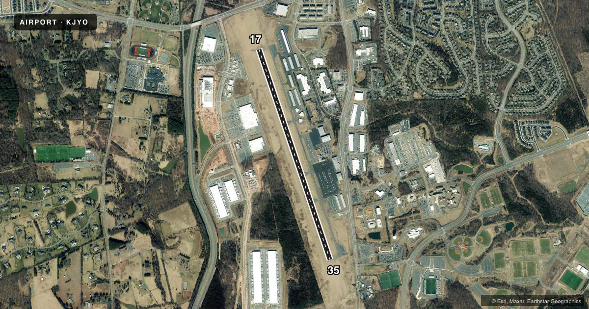
Runways & pattern
Full pagePattern entry · RWY 35
LEFT TRAFFICRunway end performance
| End | TORA | TODA | ASDA | LDA | VGSI | Approach lights | Obstruction |
|---|---|---|---|---|---|---|---|
| 17 | — | — | — | — | PAPI 4-box left(3°) | ODALS | 30', tree, 724' from thr, 520' R of cntrln, slope 17 |
| 35 | — | — | — | — | PAPI 4-box left(3°) | — | 43', pole, 1325' from thr, 272' R of cntrln, slope 26 |
Declared distances in feet. TORA = takeoff run available, TODA = takeoff distance, ASDA = accelerate-stop, LDA = landing distance.
Airport sketch
Runways drawn to scale from FAA survey coordinates, rendered over satellite imagery. Not for navigation.
Approaches & charts
ILS · 1
Services on the field
Fuel grades, oxygen, maintenance, ramp storage and lighting — as declared to the FAA by the airport operator.
Fuel & services
- Fuel
- 100LLA
- Contract fuel
- Available
- Oxygen (bottled)
- Low pressure
- Oxygen (bulk)
- Not available
- Airframe repair
- Major
- Power plant repair
- Major
- Other services
- AMB,CHTR,INSTR,RNTL,SALES
Ramp & ground
- Transient storage
- Tie-down
- Hangar
- Landing fee
- No fee published
- Customs
- Not available
- Lighting schedule
- SEE RMK
- Beacon schedule
- SS-SR
- Beacon
- White / Green (civil land)(WG)
- Wind indicator
- Yes
- Segmented circle
- Yes
Fuel & FBOs
Cheapest 100LL and Jet A on the field and nearby. Always confirm with the FBO before taxi.
Airport notes
Surface conditions, obstructions, local procedures, lighting outages and other notes published with each FAA cycle.
General notes
- BIRDS & DEER ON & INVOF ARPT.
- HEL ACT ON & INVOF ARPT.
- CALM WIND USE RWY 17.
- RAMP FENCE S/W SIDE RAMPS LEAD IN LINES ON WEST RAMP NA.
- PSBL THERMAL PLUMES FM PWR PLANT 1.3 NM SSE.
- FOR CD WHEN ATCT CLSD, CTC POTOMAC APCH 118.55 OR 866-709-4993.
Lighting notes
- WHEN ATCT CLSD ACTVT ODALS RWY 17; REIL RWY 17 & 35; PAPI RWY 17 & 35; HIRL RWY 17/35 - CTAF.
Approach & departure obstructions
- 17NSTD ODALS, 3 LGT CONFIGURATION.
Other notes
- US CUST AVBL MON-SUN 0600-2100. CALL COMMAND CNTR 703-661-2800 FOR APNTMT. 24 HR NOTICE RQRD.
VFR map & nearby airports
VFR sectional. Tap any ICAO chip to open that airport.
Key facts · KJYO
Answer card- ICAO
- KJYO
- Name
- LEESBURG EXEC
- Location
- LEESBURG, VIRGINIA
- Elevation
- 389.5 ft MSL
- Traffic pattern altitude
- 1,199.5 ft MSL (810 AGL)
- Control tower
- Towered · 1300-2300Z++
- Total runways
- 1
- Longest runway
- 17/35 · 5,500 ft
- Published ILS approaches
- 1
- Published frequencies
- 8
- Magnetic variation
- 10°
- Current flight rules
- VFR
- Current wind
- 320° at 7 kt
- Favored runway now
- RWY 35
Leesburg Exec sits in Leesburg, Virginia. Field elevation is 389.5 ft MSL. The airport has one runway, 17/35, at 5,500 ft of asphalt. The tower is open 1300-2300Z++. Pattern altitude is 810 ft AGL, which is 1,199.5 ft MSL. There is one ILS approach on runway 17.
KUHN Aviation is on the field. It carries 100LL and Jet A Prist. Call (703) 665-3000 for current service details. If you need customs, it is available Monday through Sunday from 0600 to 2100. A 24-hour notice is required. When the tower is closed, clearance delivery goes through Potomac Approach on 118.55 or 866-709-4993.
A few operational items matter here. Runway 17 has nonstandard approach lighting. When the tower is closed, the runway 17 lighting system, runway end identifier lights, PAPI on both ends and high intensity runway lights on 17/35 are activated via CTAF. The published remarks also call out birds and deer in the area, helicopter activity and possible thermal plumes from a power plant 1.3 NM south-southeast. Use runway 17 when winds are calm. Check the current FAA Chart Supplement before you go for any updated procedures or restrictions.