METAR & TAF KJEF
Current METAR
Observed 16:53Z
KJEF 271653Z 22009G17KT 10SM CLR 33/23 A2987 RMK AO2 SLP098 T03330228 $
- Wind
- 220° @ 9G17 kt
- Visibility
- 10 SM
- Temp / Dew
- 33°C / 23°C
- Altimeter
- 29.87 inHg
- Clouds
- CLR
- Density alt
- 2,903 ft
- Ceiling
- Unlimited
- Rules
- VFR
Airport info & contacts
Manager on record, flight service, ARTCC, attendance schedule and pattern altitude — published by the FAA and refreshed every 28 days.
Location
- From city
- 2 NM NE
- VFR sectional
- KANSAS CITY
- ARTCC
- ZKC · KANSAS CITY
- NOTAM facility
- JEF (NOTAM-D)
Airport manager
- Name
- ERIC BOWERS
- Phone
- 573-634-6469
- Address
- 320 E. MCCARTY ST., JEFFERSON CITY MO 65101
Flight service · Hours
- FSS COU
- COLUMBIA1-800-WX-BRIEF
- Attendance
- 0630-2030
Frequencies
Tap any row to copy the frequency to your clipboard.
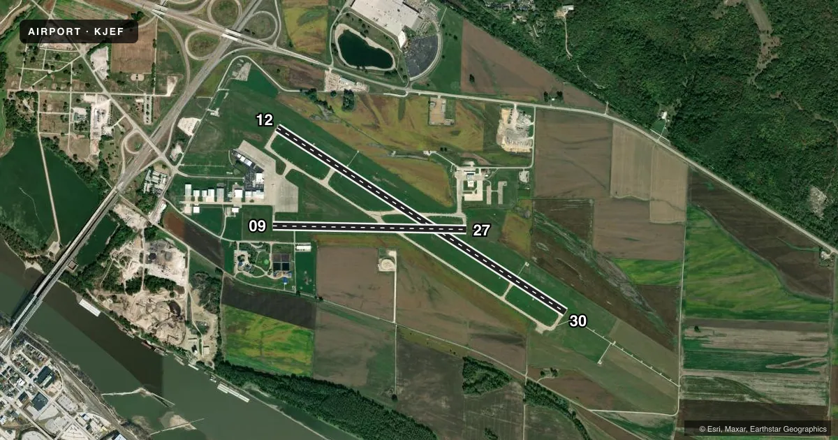
Runways & pattern
Full pagePattern entry · RWY 27
LEFT TRAFFIC| Runway | Heading (°M) | Length | Surface | Traffic |
|---|---|---|---|---|
| 12/30 | 122° / 302° | 6,000 ft | CONC | Standard L |
| 09/27Favored | 90° / 270° | 3,401 ft | CONC | Standard L |
Runway end performance
| End | TORA | TODA | ASDA | LDA | VGSI | Approach lights | Obstruction |
|---|---|---|---|---|---|---|---|
| 12 | — | — | — | — | VASI 4-box left(3.5°) | — | — |
| 30 | — | — | — | — | VASI 4-box left(3°) | MALSR | — |
| 09 | — | — | — | — | PAPI 4-box left(3°) | — | 23', hangar, 600' from thr, 230' R of cntrln, slope 17 |
| 27 | — | — | — | — | PAPI 4-box left(3°) | — | 53', trees, 1127' from thr, 75' R of cntrln, slope 17 |
Declared distances in feet. TORA = takeoff run available, TODA = takeoff distance, ASDA = accelerate-stop, LDA = landing distance.
Airport sketch
Runways drawn to scale from FAA survey coordinates, rendered over satellite imagery. Not for navigation.
Approaches & charts
ILS · 1
Services on the field
Fuel grades, oxygen, maintenance, ramp storage and lighting — as declared to the FAA by the airport operator.
Fuel & services
- Fuel
- 100LLA
- Oxygen (bottled)
- HIGH/LOW
- Oxygen (bulk)
- Not available
- Airframe repair
- Major
- Power plant repair
- Major
- Other services
- AFRT,CHTR,INSTR,RNTL,SALES
Ramp & ground
- Transient storage
- Tie-down
- Hangar
- Landing fee
- No fee published
- Customs
- Not available
- Lighting schedule
- SEE RMK
- Beacon schedule
- SS-SR
- Beacon
- White / Green (civil land)(WG)
- Wind indicator
- Lighted
- Segmented circle
- No
Fuel & FBOs
Cheapest 100LL and Jet A on the field and nearby. Always confirm with the FBO before taxi.
Airport notes
Surface conditions, obstructions, local procedures, lighting outages and other notes published with each FAA cycle.
General notes
- LIGHT TO MODERATE BIRD ACTVTY INVOF ARPT.
- ENTRANCES TO E & S HANGARS, NOT VISIBLE BY TWR.
- ARFF AVBL WITH PPR 24 HOURS 573-634-6469.
- FOR CD CTC MIZZOU APCH AT 417-868-5620/5619.
Lighting notes
- WHEN ATCT CLSD ACTVT MALSR RWY 30; REIL RWYS 9, 12, 27; HIRL RWY 12/30; & TWY A LGTS - CTAF. VASI RWYS 12 & 30 OPR CONSLY.
Fuel notes
- 100LLAVBL FROM 0630 - 2030 Z++.
Other notes
- E111 PRVDD APCH TO EACH RWY IS MAINTD FOR A MIN 20:1 GLIDE SLOPE & THE TRANSITIONAL SFC MAINTD FOR A 7:1 SLOPE.
VFR map & nearby airports
VFR sectional. Tap any ICAO chip to open that airport.
Key facts · KJEF
Answer card- ICAO
- KJEF
- Name
- JEFFERSON CITY MEML
- Location
- JEFFERSON CITY, MISSOURI
- Elevation
- 549.4 ft MSL
- Traffic pattern altitude
- 1,549.4 ft MSL (1,000 AGL)
- Control tower
- Towered · 0600-2130
- Total runways
- 2
- Longest runway
- 12/30 · 6,000 ft
- Published ILS approaches
- 1
- Published frequencies
- 7
- Magnetic variation
- 1°
- Current flight rules
- VFR
- Current wind
- 220° at 9 kt
- Favored runway now
- RWY 27
Jefferson City Memorial Airport (KJEF) sits in Jefferson City, Missouri. Field elevation is 549.4 ft MSL. The airport has two concrete runways. The longest is 6,000 ft on runway 12/30. Runway 09/27 is 3,401 ft. The field is towered from 0600 to 2130. Check the current FAA Chart Supplement for any changes to tower hours before you go.
One ILS approach is published for runway 30. Pattern altitude is not published in the facts, so use the standard 1,000 ft AGL for light piston traffic unless ATC or the Chart Supplement says otherwise. Jefferson City Flying Service is on the field. It carries 100LL and Jet A Prist. 100LL is available from 0630 to 2030 Zulu. Light to moderate bird activity is reported in the area. The published remarks also note that runway 30 lighting can be activated by CTAF when the tower is closed. The VASI on runways 12 and 30 operate continuously.
For a first-time arrival, the main things to plan for are the towered environment, the single ILS on 30 and the runway lighting procedures after tower hours. The airport also notes that clearance delivery is handled through Mizzou Approach. If you need current operational details, call the airport operator or the FBO directly by phone.