METAR & TAF KIRK
Current METAR
Observed 15:55Z
KIRK 271555Z AUTO 20008KT 10SM SCT100 29/24 A2984 RMK AO2 SLP097 T02890239 TSNO $
- Wind
- 200° @ 8 kt
- Visibility
- 10 SM
- Temp / Dew
- 29°C / 24°C
- Altimeter
- 29.84 inHg
- Clouds
- SCT
- Density alt
- 2,977 ft
- Ceiling
- Unlimited
- Rules
- VFR
Airport info & contacts
Manager on record, flight service, ARTCC, attendance schedule and pattern altitude — published by the FAA and refreshed every 28 days.
Location
- From city
- 6 NM SE
- VFR sectional
- CHICAGO
- ARTCC
- ZKC · KANSAS CITY
- NOTAM facility
- IRK (NOTAM-D)
Airport manager
- Name
- JEFFERY LAFOUNTAIN
- Phone
- 660-665-5020
- Address
- 27161 DAVID HALL TRAIL, KIRKSVILLE MO 63501
Flight service · Hours
- FSS COU
- COLUMBIA1-800-WX-BRIEF
- Attendance
- 0530-2000
Frequencies
Tap any row to copy the frequency to your clipboard.
Runways & pattern
Full pagePattern entry · RWY 18
LEFT TRAFFIC| Runway | Heading (°M) | Length | Surface | Traffic |
|---|---|---|---|---|
| 18/36Favored | 177° / 357° | 6,005 ft | CONC | Standard L |
| 09/27 | 88° / 268° | 1,370 ft | TURF | Standard L |
Runway end performance
| End | TORA | TODA | ASDA | LDA | VGSI | Approach lights | Obstruction |
|---|---|---|---|---|---|---|---|
| 18 | 6,005' | 6,005' | 6,005' | 6,005' | VASI 4-box left(3°) | — | — |
| 36 | 6,005' | 6,005' | 6,005' | 6,005' | VASI 4-box left(3°) | MALSR | — |
| 09 | — | — | — | — | — | — | 72', trees, 1440' from thr, 0' R of cntrln, slope 20 |
| 27 | — | — | — | — | — | — | 47', trees, 1240' from thr, 0' R of cntrln, slope 26 |
Declared distances in feet. TORA = takeoff run available, TODA = takeoff distance, ASDA = accelerate-stop, LDA = landing distance.
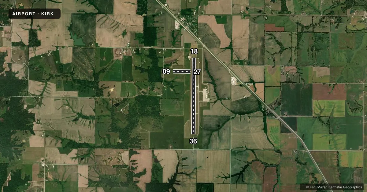
Airport sketch
Runways drawn to scale from FAA survey coordinates, rendered over satellite imagery. Not for navigation.
Approaches & charts
ILS · 1
Services on the field
Fuel grades, oxygen, maintenance, ramp storage and lighting — as declared to the FAA by the airport operator.
Fuel & services
- Fuel
- 100LLA
- Oxygen (bottled)
- Not available
- Oxygen (bulk)
- Not available
- Airframe repair
- Major
- Power plant repair
- Major
- Other services
- AFRT,AVNCS,CARGO,CHTR,INSTR,RNTL,SALES
Ramp & ground
- Transient storage
- Tie-down
- Hangar
- Landing fee
- No fee published
- Customs
- Not available
- Lighting schedule
- SEE RMK
- Beacon schedule
- SS-SR
- Beacon
- White / Green (civil land)(WG)
- Wind indicator
- Lighted
- Segmented circle
- Yes
Fuel & FBOs
Cheapest 100LL and Jet A on the field and nearby. Always confirm with the FBO before taxi.
Airport notes
Surface conditions, obstructions, local procedures, lighting outages and other notes published with each FAA cycle.
General notes
- FOR CD IF UNA TO CTC ON FSS FREQ, CTC KANSAS CITY ARTCC AT 913-254-8508.
Lighting notes
- ACTVT HIRL RY 18/36; VASI RYS 18 & 36; REIL RY 18 & MALSR RY 36 - CTAF.
Runway surface & condition
- 18/36PCR VALUE: 140/R/D/W/T
- 09/27RWY 09/27 NOT AVBL FOR PART 121/PART 380 OPS WITH SKED PAX CARRYING OPS MORE THAN 9 PAX SEATS AND NON-SKED PAX CARRYING OPS MORE THAN 30 PAX SEATS.
Approach & departure obstructions
- 0909/27 MARKED WITH YELLOW CONES.
Other notes
- MANAGERAIRPORT DIRECTOR
VFR map & nearby airports
VFR sectional. Tap any ICAO chip to open that airport.
Key facts · KIRK
Answer card- ICAO
- KIRK
- Name
- KIRKSVILLE RGNL
- Location
- KIRKSVILLE, MISSOURI
- Elevation
- 966.3 ft MSL
- Traffic pattern altitude
- 1,966.3 ft MSL (1,000 AGL)
- Control tower
- Non-towered (use CTAF)
- Total runways
- 2
- Longest runway
- 18/36 · 6,005 ft
- Published ILS approaches
- 1
- Published frequencies
- 2
- Magnetic variation
- 3°
- Current flight rules
- VFR
- Current wind
- 200° at 8 kt
- Favored runway now
- RWY 18
Kirksville Regional Airport sits in Kirksville, Missouri. Field elevation is 966.3 ft MSL. The airport has two runways. The longest is 18/36 at 6,005 ft of concrete. Runway 09/27 is 1,370 ft of turf. There is no control tower, so use CTAF 122.8 for local traffic and listen closely before joining. One ILS is published for runway 36. The pattern altitude is not published, so use the standard 1,000 ft AGL for light piston operations unless the current Chart Supplement says otherwise.
The on-field FBO is Kirksville Regional Airport. It carries AVGAS 100LL and Jet A Prist. If you need current service details, call them at (660) 665-5020 before arrival. Published remarks note high intensity lighting on runway 18/36. Runway 36 also has a medium intensity approach lighting system with runway alignment indicator lights. Runway 18 has runway end identifier lights. Runway 09/27 is marked with yellow cones. The pavement rating for 18/36 is 140 rigid dual wheel tandem. For a first-time arrival, the main thing to plan for is the non-towered flow on the concrete runway. The published ILS and lighting on 36 matter if you are coming in at night or in lower weather.