METAR & TAF KIPT
Current METAR
Observed 12:54Z
KIPT 271254Z 28006KT 10SM CLR 22/17 A2986 RMK AO2 SLP109 T02220172 $
- Wind
- 280° @ 6 kt
- Visibility
- 10 SM
- Temp / Dew
- 22°C / 17°C
- Altimeter
- 29.86 inHg
- Clouds
- CLR
- Density alt
- 1,569 ft
- Ceiling
- Unlimited
- Rules
- VFR
Airport info & contacts
Manager on record, flight service, ARTCC, attendance schedule and pattern altitude — published by the FAA and refreshed every 28 days.
Location
- From city
- 4 NM E
- VFR sectional
- NEW YORK
- ARTCC
- ZNY · NEW YORK
- NOTAM facility
- IPT (NOTAM-D)
Airport manager
- Name
- ERIC MCKITISH
- Phone
- 570-368-2444
- Address
- 724 AIRPORT RD, MONTOURSVILLE PA 17754
Flight service · Hours
- FSS IPT
- WILLIAMSPORT1-800-WX-BRIEF
- Attendance
- MON-FRI · 0430-2000
- SAT-SUN · 0700-2000
Frequencies
Tap any row to copy the frequency to your clipboard.
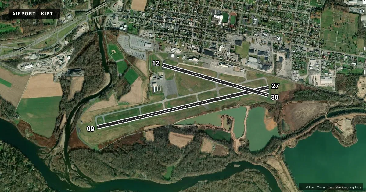
Runways & pattern
Full pagePattern entry · RWY 30
RIGHT TRAFFIC| Runway | Heading (°M) | Length | Surface | Traffic |
|---|---|---|---|---|
| 09/27 | 67° / 247° | 6,825 ft | ASPH | 27 R |
| 12/30Favored | 96° / 276° | 4,273 ft | ASPH | 30 R |
Runway end performance
| End | TORA | TODA | ASDA | LDA | VGSI | Approach lights | Obstruction |
|---|---|---|---|---|---|---|---|
| 09 | 6,825' | 6,825' | 6,073' | 6,073' | PAPI 4-box left(3°) | — | 62', trees, 657' from thr, 441' R of cntrln, slope 7 |
| 27 | 6,825' | 6,825' | 6,318' | 6,063' | — | MALSR | 77', trees, 955' from thr, 552' R of cntrln, slope 9 |
| 12 | 4,273' | 4,273' | 4,273' | 4,273' | PAPI 2-box left(3.75°) | — | 97', trees, 2002' from thr, 511' R of cntrln, slope 18 |
| 30 | 4,273' | 4,273' | 4,273' | 4,273' | PAPI 2-box left(4°) | — | 32', trees, 334' from thr, 263' R of cntrln, slope 4 |
Declared distances in feet. TORA = takeoff run available, TODA = takeoff distance, ASDA = accelerate-stop, LDA = landing distance.
Airport sketch
Runways drawn to scale from FAA survey coordinates, rendered over satellite imagery. Not for navigation.
Approaches & charts
ILS · 1
Services on the field
Fuel grades, oxygen, maintenance, ramp storage and lighting — as declared to the FAA by the airport operator.
Fuel & services
- Fuel
- 100LLA
- Oxygen (bottled)
- Not available
- Oxygen (bulk)
- High pressure
- Airframe repair
- Major
- Power plant repair
- Major
- Other services
- AVNCS,CARGO,INSTR,RNTL,SALES
Ramp & ground
- Transient storage
- Tie-down
- Hangar
- Landing fee
- Yes
- Customs
- Not available
- Lighting schedule
- SEE RMK
- Beacon schedule
- SS-SR
- Beacon
- White / Green (civil land)(WG)
- Wind indicator
- Lighted
- Segmented circle
- Yes
Fuel & FBOs
Cheapest 100LL and Jet A on the field and nearby. Always confirm with the FBO before taxi.
Airport notes
Surface conditions, obstructions, local procedures, lighting outages and other notes published with each FAA cycle.
General notes
- DEER & BIRDS ON & INVOF ARPT SPCLY AER 27 & AER 30
- TWY 'J' CLSD TO ACFT WITH WING SPAN OVER 78 FT.
- FOR LANDSIDE ACCESS FM ARPT AFTER HRS USE COMPUTERIZED GATE SYSTEM AT EAST END OR FBO APRON.
- UNLGTD CRANE 90 FT AGL .5 MI SE AER 30 PERMLY.
- COLD TEMPERATURE AIRPORT. ALTITUDE CORRECTION REQUIRED AT OR BELOW -13C.
- FOR CD IF UNA TO CTC ON FSS FREQ, CTC NEW YORK ARTCC AT 631-468-1425.
- RWY & TWY CONDS NOT MNT DLY 1700-0700.
Lighting notes
- DUSK-DAWN. WHEN ATCT CLSD ACTVT MALSR RWY 27; REIL RWY 09; HIRL RWY 09/27; MIRL RWY 12/30; AND TWY LGTS - CTAF. PAPI RWYS 09, 12 & 30 OPER CONSLY. MIRL RWY 12/30, CLICK THREE TIMES FOR MEDIUM INTST.
Fuel notes
- 100LLFUEL & SVCS AVBL 0700-2200 DLY; AFTER HRS BY PRIOR CDN CALL 570-368-2651.
Runway surface & condition
- 09/27PCR VALUE: 690/F/A/X/T
- 12/30PCR VALUE: 2230/F/C/X/T
Approach & departure obstructions
- 09RWY 09 PAPI BAFFLED UNUSBL BYD 2 DEGS R OF CRS.
- 30RWY 30 PAPI BAFFLED UNUSBL BYD 7 DEGS L OF CRS.
- 0916:1 TO DSPLCD THLD.
Other notes
- ESTAB PRIOR TO RQMT
- PPR 12 HRS FOR UNSKED ACR OPNS WITH MORE THAN 30 PSGR SEATS CALL AMGR. INDEX A COVERAGE AVBL 0700-1700 AND BTN 1700-0700 UPON REQ CALL AMGR. INDEX B COVERAGE AVBL UPON REQ CALL AMGR.
VFR map & nearby airports
VFR sectional. Tap any ICAO chip to open that airport.
Key facts · KIPT
Answer card- ICAO
- KIPT
- Name
- WILLIAMSPORT RGNL
- Location
- WILLIAMSPORT, PENNSYLVANIA
- Elevation
- 528.1 ft MSL
- Traffic pattern altitude
- 1,528.1 ft MSL (1,000 AGL)
- Control tower
- Towered · 0630-2230
- Total runways
- 2
- Longest runway
- 09/27 · 6,825 ft
- Published ILS approaches
- 1
- Published frequencies
- 7
- Magnetic variation
- 10°
- Current flight rules
- VFR
- Current wind
- 280° at 6 kt
- Favored runway now
- RWY 30
Williamsport Rgnl sits in Williamsport, Pennsylvania. The field elevation is 528.1 ft MSL. It has two asphalt runways. The longest is runway 09/27 at 6,825 ft. Runway 12/30 is 4,273 ft.
The airport has a control tower. Tower hours are 0630-2230. There is one ILS approach. It serves runway 27. Pattern altitude is not published in the facts block. Use 1,000 ft AGL for light piston traffic unless ATC or the current Chart Supplement says otherwise.
Energy Aviation is on the field. It carries 100LL and Jet A Prist. For after-hours lighting, the published remarks say the runway and taxiway lights can be activated by CTAF when the tower is closed. The PAPI on runways 09, 12 and 30 operate continuously. One operational item to watch is the unlighted crane 0.5 miles southeast of runway 30. The airport is also listed as a cold temperature airport. Altitude correction is required at or below minus 13 degrees Celsius. Taxiway J is closed to aircraft with wingspans over 78 feet. Runway and taxiway conditions are not maintained daily from 1700 to 0700, so plan your arrival and departure with that in mind.