METAR & TAF KILM
Current METAR
Observed 14:53Z
KILM 271453Z 14006KT 10SM FEW027 SCT036 BKN046 28/22 A2987 RMK AO2 SLP115 T02830222 51005
- Wind
- 140° @ 6 kt
- Visibility
- 10 SM
- Temp / Dew
- 28°C / 22°C
- Altimeter
- 29.87 inHg
- Clouds
- BKN
- Density alt
- 1,661 ft
- Ceiling
- 4,600 ft AGL
- Rules
- VFR
Airport info & contacts
Manager on record, flight service, ARTCC, attendance schedule and pattern altitude — published by the FAA and refreshed every 28 days.
Location
- From city
- 3 NM NE
- VFR sectional
- CHARLOTTE
- ARTCC
- ZDC · WASHINGTON
- NOTAM facility
- ILM (NOTAM-D)
Airport manager
- Name
- JEFFREY BOURK, A.A.E.
- Phone
- 910-341-4333
- Address
- 1740 AIRPORT BLVD, WILMINGTON NC 28405
Flight service · Hours
- FSS RDU
- RALEIGH1-800-WX-BRIEF
- Attendance
- ALL
Frequencies
Tap any row to copy the frequency to your clipboard.
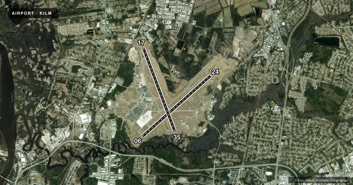
Runways & pattern
Full pagePattern entry · RWY 17
LEFT TRAFFIC| Runway | Heading (°M) | Length | Surface | Traffic |
|---|---|---|---|---|
| 06/24 | 38° / 218° | 8,016 ft | ASPH | Standard L |
| 17/35Favored | 149° / 329° | 7,754 ft | ASPH | Standard L |
Runway end performance
| End | TORA | TODA | ASDA | LDA | VGSI | Approach lights | Obstruction |
|---|---|---|---|---|---|---|---|
| 06 | 8,016' | 8,016' | 8,016' | 8,016' | PAPI 4-box right(3°) | — | — |
| 24 | 8,016' | 8,016' | 8,016' | 8,016' | PAPI 4-box left(3°) | MALSR | — |
| 17 | 7,754' | 7,754' | 6,954' | 6,604' | PAPI 4-box left(3°) | — | — |
| 35 | 7,754' | 7,754' | 7,604' | 7,204' | PAPI 4-box left(3°) | MALSR | — |
Declared distances in feet. TORA = takeoff run available, TODA = takeoff distance, ASDA = accelerate-stop, LDA = landing distance.
Airport sketch
Runways drawn to scale from FAA survey coordinates, rendered over satellite imagery. Not for navigation.
Approaches & charts
ILS · 3
Services on the field
Fuel grades, oxygen, maintenance, ramp storage and lighting — as declared to the FAA by the airport operator.
Fuel & services
- Fuel
- 100LLAA+
- Oxygen (bottled)
- HIGH/LOW
- Oxygen (bulk)
- HIGH/LOW
- Airframe repair
- Major
- Power plant repair
- Major
- Other services
- AFRT,CARGO,CHTR,INSTR,RNTL,SALES
Ramp & ground
- Transient storage
- Tie-down
- Hangar
- Landing fee
- No fee published
- Customs
- Not available
- Lighting schedule
- SEE RMK
- Beacon schedule
- SS-SR
- Beacon
- White / Green (civil land)(WG)
- Wind indicator
- Lighted
Fuel & FBOs
Cheapest 100LL and Jet A on the field and nearby. Always confirm with the FBO before taxi.
Airport notes
Surface conditions, obstructions, local procedures, lighting outages and other notes published with each FAA cycle.
General notes
- FUEL: AIR WILMINGTON, INC, 910-763-4691.
- FOR CD IF UNA TO CTC ON FSS FREQ, CTC WASHINGTON ARTCC AT 703-771-3587.
- PILOTS CONDUCTING EFVS OPS; BE AWARE LED ALS IN USE RWY 35.
Lighting notes
- ACTVT MALSR RWY 24 & 35; REIL RWY 06 & 17; PAPI RWY 06, 17, 24; HIRL RWY 06/24 & 17/35; AND ALL TWY LGTS - CTAF.
Runway surface & condition
- 06/24PCR VALUE: 470/F/B/X/T
- 17/35PCR VALUE: 480/F/B/X/T
- 06/24WT LMT FOR RWY 06-24: USE ACFT PCR FOR ALL GEAR TYPES OTHER THAN "S" OR D".
- 17/35WT LMT FOR RWY 17-35: USE ACFT PCR FOR ALL GEAR TYPES OTHER THAN "S" OR "D".
Other notes
- TPA: ARPT IN EXISTENCE IN 1956.
- TPA: 1000 FT AGL RECIPROCATING ENGINE, 1500 FT AGL TBJT/JET. OHD: 5 MILE INITIAL 2500 FT AGL, BREAK 2000 FT AGL. TOWER CALLS DRCTN OF BREAK. CARRIER BREAK NA.
- MANAGEREXT 1001.
VFR map & nearby airports
VFR sectional. Tap any ICAO chip to open that airport.
Key facts · KILM
Answer card- ICAO
- KILM
- Name
- WILMINGTON INTL
- Location
- WILMINGTON, NORTH CAROLINA
- Elevation
- 31.7 ft MSL
- Traffic pattern altitude
- 1,031.7 ft MSL (1,000 AGL)
- Control tower
- Towered · 0600-2300
- Total runways
- 2
- Longest runway
- 06/24 · 8,016 ft
- Published ILS approaches
- 3
- Published frequencies
- 18
- Magnetic variation
- 10°
- Current flight rules
- VFR
- Current wind
- 140° at 6 kt
- Favored runway now
- RWY 17
Wilmington Intl sits in Wilmington, North Carolina. Field elevation is 31.7 ft MSL. The airport has two asphalt runways. The longest is 8,016 ft on 06/24. Runway 17/35 is 7,754 ft. The tower is open 0600-2300. Three ILS approaches are published. They serve runway ends 06, 24 and 35.
Pattern altitude is not published in the facts block. Use the standard 1,000 ft AGL for light piston traffic unless ATC or the current Chart Supplement says otherwise. The published remarks also call out different pattern altitudes for reciprocating aircraft versus turboprops and jets. Overhead traffic is also published with a five-mile initial at 2,500 ft AGL and a break at 2,000 ft AGL. The tower calls the break direction. Carrier break is not authorized.
Two on-field FBOs are listed. Modern Aviation carries AVGAS 100LL, JET A and JET A PRIST. Aero Center carries AVGAS 100LL, JET A and JET A PRIST. For runway use, note the published weight limits and pavement classification ratings on both runways. Runway lighting is well equipped. MALSR is on 24 and 35. REIL is on 06 and 17. PAPI is on 06, 17 and 24. Taxiway lights are on CTAF. If you need clearance delivery and cannot raise Flight Service, the remarks say to contact Washington ARTCC.