METAR & TAF KELM
Current METAR
Observed 12:53Z
KELM 271253Z 00000KT 7SM FEW003 18/17 A2987 RMK AO2 SLP111 T01780172
- Wind
- 000° @ 0 kt
- Visibility
- 7 SM
- Temp / Dew
- 18°C / 17°C
- Altimeter
- 29.87 inHg
- Clouds
- FEW
- Density alt
- 1,606 ft
- Ceiling
- Unlimited
- Rules
- VFR
Airport info & contacts
Manager on record, flight service, ARTCC, attendance schedule and pattern altitude — published by the FAA and refreshed every 28 days.
Location
- From city
- 6 NM NW
- VFR sectional
- NEW YORK
- Pattern altitude
- 1,545 ft AGL · 2,500 ft MSL
- ARTCC
- ZNY · NEW YORK
- NOTAM facility
- ELM (NOTAM-D)
Airport manager
- Name
- THOMAS FREEMAN
- Phone
- 607-739-5621
- Address
- 276 SING SING RD.,SUITE 1, HORSEHEADS NY 14845
Flight service · Hours
- FSS BUF
- BUFFALO1-800-WX-BRIEF
- Attendance
- ALL
Frequencies
Tap any row to copy the frequency to your clipboard.
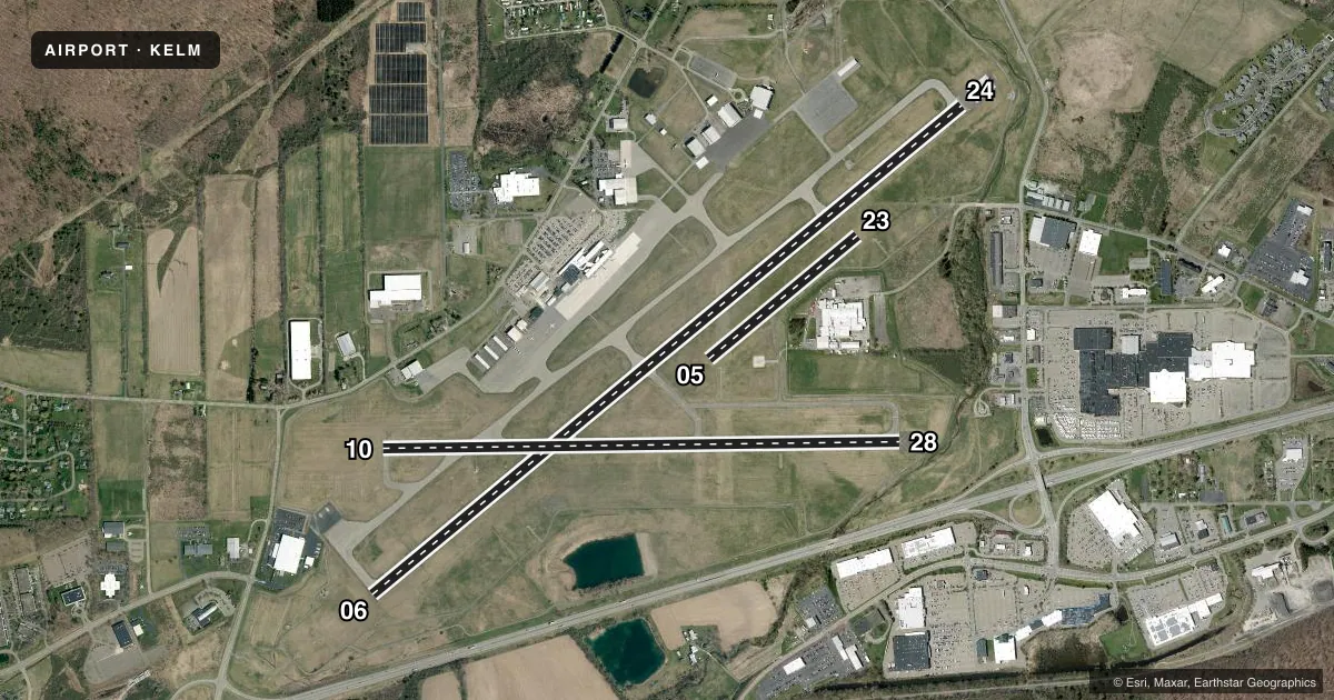
Runways & pattern
Full pagePattern entry · RWY 06
LEFT TRAFFIC| Runway | Heading (°M) | Length | Surface | Traffic |
|---|---|---|---|---|
| 06/24 | 38° / 218° | 8,001 ft | ASPH | Standard L |
| 10/28 | 77° / 257° | 5,404 ft | ASPH | Standard L |
| 05/23 | 38° / 218° | 2,016 ft | TURF | Standard L |
Runway end performance
| End | TORA | TODA | ASDA | LDA | VGSI | Approach lights | Obstruction |
|---|---|---|---|---|---|---|---|
| 06 | 8,001' | 8,001' | 8,001' | 7,401' | VASI 4-box left(3°) | MALSR | 790', tree, 27250' from thr, 1800' R of cntrln, slope 34 |
| 24 | 8,001' | 8,001' | 8,001' | 7,799' | PAPI 4-box left(3°) | MALSR | 382', tree, 12329' from thr, 2123' R of cntrln, slope 31 |
| 10 | 5,404' | 5,404' | 5,004' | 5,004' | — | — | 632', trees, 8761' from thr, 1488' R of cntrln, slope 13 |
| 28 | 5,404' | 5,404' | 5,404' | 5,002' | PAPI 4-box left(3°) | — | 54', pole, 1351' from thr, 264' R of cntrln, slope 21 |
| 05 | 2,017' | 2,017' | 2,017' | 2,017' | — | — | — |
| 23 | 2,017' | 2,017' | 2,017' | 2,017' | — | — | — |
Declared distances in feet. TORA = takeoff run available, TODA = takeoff distance, ASDA = accelerate-stop, LDA = landing distance.
Airport sketch
Runways drawn to scale from FAA survey coordinates, rendered over satellite imagery. Not for navigation.
Approaches & charts
ILS · 2
Services on the field
Fuel grades, oxygen, maintenance, ramp storage and lighting — as declared to the FAA by the airport operator.
Fuel & services
- Fuel
- 100LLA
- Oxygen (bottled)
- Low pressure
- Oxygen (bulk)
- Not available
- Airframe repair
- Major
- Power plant repair
- Major
- Other services
- CARGO,CHTR,INSTR,RNTL,SALES
Ramp & ground
- Transient storage
- Tie-down
- Hangar
- Landing fee
- Yes
- Customs
- Not available
- Lighting schedule
- SEE RMK
- Beacon schedule
- SS-SR
- Beacon
- White / Green (civil land)(WG)
- Wind indicator
- Lighted
- Segmented circle
- No
Fuel & FBOs
Cheapest 100LL and Jet A on the field and nearby. Always confirm with the FBO before taxi.
Airport notes
Surface conditions, obstructions, local procedures, lighting outages and other notes published with each FAA cycle.
General notes
- ACFT WITH WINGSPANS GTR THAN 93 FEET SHOULD USE EXTREME CARE WHEN TAXIING ON TWY T ADJ TO APRONS.
- EXTSV GLIDER ACT ON & INVOF ARPT.
- BIRDS & DEER ON & INVOF ARPT.
- RWY 05/23 (SOUTHEAST OF RWY 06/24) UNMARKED SEASONAL USE TURF RWY CLSD 1 DEC THROUGH 30 APR.
- FOR LAND SIDE ACCESS FM APRON WHEN FBO CLSD CTC ELM ARPT ATTENDANT AT 607-426-5621.
- WINTER DE-ICING ON GLYCOL APRON ONLY.
- BLIMP ACT RQRS PPR, CTC ARPT MGMT AT 607-426-5621.
- RWY 10 OPNS PROHIBITED FOR ACFT WITH APCH SPEEDS GTR THAN OR EQUAL TO 121 KNOTS AND/OR WINGSPANS GTR THAN OR EQUAL TO 118 FT .
- COLD TEMPERATURE AIRPORT. ALTITUDE CORRECTION REQUIRED AT OR BELOW -21C.
- TWY H, J, & L LTD TO DESIGN GROUP II ACFT.
- TRML RAMP IS UNCONTROLLED. DO NOT CALL FOR PUSH/POWER BACK. ADVISE GC WHEN READY TO TAXI FOR DEP.
- TWY T BTN TXY L AND TWY D NONMOVEMENT AREA.
- FOR CD IF UNA TO CTC ON FSS FREQ, CTC NEW YORK ARTCC AT 631-468-1425.
Lighting notes
- WHEN ATCT CLSD ACTVT MALSR RWY 06 & 24; HIRL RWY 06/24; MIRL RWY 10/28; TWY LGTS - CTAF.
Runway surface & condition
- 06/24PCR VALUE: 560/F/B/X/T
- 10/28PCR VALUE: 640/F/B/X/T
Approach & departure obstructions
- 05RWY 05/23 MKD WITH ASPH L CORNER MARKERS.
- 24PAPI UNUSBL BYD 9 DEGS RIGHT OF CNTRLN.
Arresting gear
- 06_EMASENGINEERED MATERIALS ARRESTING SYSTEM (EMAS) 259 FT IN LENGTH BY 170 FT IN WIDTH LCTD AT DER 06.
Other notes
- EXISTED PRIOR TO 1959.
- ARFF INDEX C EQUIPMENT COVERAGE IS AVBL UPON REQUEST CTC ARPT MANAGEMENT AT 607-426-5621.
- LNDG FEE FOR ALL NON BASED ACFT.
- TPA: 1545 FT AGL RECIPROCATING ENG, 2045 FT AGL TURBOPROP/JET.
- OWNEROR 607-739-5622.
VFR map & nearby airports
VFR sectional. Tap any ICAO chip to open that airport.
Key facts · KELM
Answer card- ICAO
- KELM
- Name
- ELMIRA/CORNING RGNL
- Location
- ELMIRA/CORNING, NEW YORK
- Elevation
- 955.1 ft MSL
- Traffic pattern altitude
- 2,500.1 ft MSL (1,545 AGL)
- Control tower
- Towered · 0600-0000
- Total runways
- 3
- Longest runway
- 06/24 · 8,001 ft
- Published ILS approaches
- 2
- Published frequencies
- 14
- Magnetic variation
- 12°
- Current flight rules
- VFR
- Current wind
- 000° at 0 kt
- Favored runway now
- –
Elmira/Corning Regional Airport sits in Elmira/Corning, New York. The field elevation is 955.1 ft MSL. It has three runways. The longest is runway 06/24 at 8,001 ft. The airport is towered. Tower hours are 0600-0000.
Two ILS approaches are published here. They serve runways 06 and 24. Pattern altitude is 1,545 ft AGL, which is 2,500.1 ft MSL. For reciprocating aircraft, that is the published pattern altitude. Turboprops and jets use 2,045 ft AGL.
Premier Aviation is on the field. It carries 100LL, Jet A and Jet A Prist. Atlantic Aviation is also on the field. It carries 100LL and Jet A. The terminal ramp is uncontrolled, so do not call for push or power back. Advise ground control when you are ready to taxi.
This is a cold temperature airport. Altitude correction is required at or below minus 21 degrees Celsius. There is also extensive glider activity on and near the airport, so expect extra traffic scanning work. Runway 10 has published limits for aircraft at or above 121 knots approach speed or 118 ft wingspan. Taxiway T needs extra care for aircraft over 93 ft wingspan. Check the current Chart Supplement for any noise or curfew restrictions before flying into the field.