METAR & TAF KEFD
Current METAR
Observed 09:54Z
KEFD 270954Z 00000KT 10SM CLR 26/24 A2996
- Wind
- 000° @ 0 kt
- Visibility
- 10 SM
- Temp / Dew
- 26°C / 24°C
- Altimeter
- 29.96 inHg
- Clouds
- CLR
- Density alt
- 1,311 ft
- Ceiling
- Unlimited
- Rules
- VFR
Airport info & contacts
Manager on record, flight service, ARTCC, attendance schedule and pattern altitude — published by the FAA and refreshed every 28 days.
Location
- From city
- 15 NM SE
- VFR sectional
- HOUSTON
- Pattern altitude
- 600 ft AGL · 633 ft MSL
- ARTCC
- ZHU · HOUSTON
- NOTAM facility
- EFD (NOTAM-D)
Airport manager
- Name
- ARTURO MACHUCA
- Phone
- 713-847-4200
- Address
- BLDG 510 ELLINGTON FIELD, HOUSTON TX 77034
Flight service · Hours
- FSS FTW
- FORT WORTH1-800-WX-BRIEF
- Attendance
- ALL
Frequencies
Tap any row to copy the frequency to your clipboard.
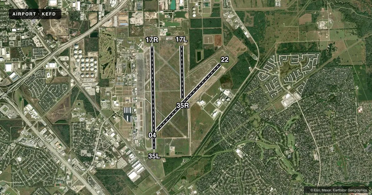
Runways & pattern
Full pagePattern entry · RWY 17R
LEFT TRAFFIC| Runway | Heading (°M) | Length | Surface | Traffic |
|---|---|---|---|---|
| 17R/35L | 174° / 354° | 9,001 ft | CONC | 35L R |
| 04/22 | 39° / 219° | 8,001 ft | CONC | 04 R |
| 17L/35R | 174° / 354° | 4,609 ft | CONC | 35R R |
Runway end performance
| End | TORA | TODA | ASDA | LDA | VGSI | Approach lights | Obstruction |
|---|---|---|---|---|---|---|---|
| 17R | 9,001' | 9,001' | 9,001' | 9,001' | PAPI 4-box left(3°) | MALSF | — |
| 35L | 9,001' | 9,001' | 9,001' | 9,001' | PAPI 4-box left(3°) | MALSF | — |
| 04 | 8,001' | 8,001' | 8,001' | 8,001' | PAPI 4-box left(3°) | — | — |
| 22 | 8,001' | 8,001' | 8,001' | 8,001' | PAPI 4-box left(3°) | MALSR | — |
| 17L | 4,609' | 4,609' | 4,609' | 4,609' | — | — | — |
| 35R | 4,609' | 4,609' | 4,609' | 4,609' | — | — | — |
Declared distances in feet. TORA = takeoff run available, TODA = takeoff distance, ASDA = accelerate-stop, LDA = landing distance.
Airport sketch
Runways drawn to scale from FAA survey coordinates, rendered over satellite imagery. Not for navigation.
Approaches & charts
ILS · 3
Services on the field
Fuel grades, oxygen, maintenance, ramp storage and lighting — as declared to the FAA by the airport operator.
Fuel & services
- Fuel
- 100LLA
- Oxygen (bottled)
- Low pressure
- Oxygen (bulk)
- Low pressure
- Airframe repair
- Major
- Power plant repair
- Major
- Other services
- CARGO,INSTR,RNTL
Ramp & ground
- Transient storage
- Tie-down
- Lighting schedule
- SS-SR
- Beacon schedule
- SS-SR
- Beacon
- White / Green (civil land)(WG)
- Wind indicator
- Lighted
- Segmented circle
- No
Fuel & FBOs
Cheapest 100LL and Jet A on the field and nearby. Always confirm with the FBO before taxi.
Airport notes
Surface conditions, obstructions, local procedures, lighting outages and other notes published with each FAA cycle.
General notes
- TWY B UNLGTD EAST OF RY 17R/35L; DALGT USE ONLY.
- BE ALERT FOR MIL ACFT AT 1600 MSL MAKING OVHD APCHS.
- 70 FT AGL TANKS LCTD 1400 FT NE OF RY 17R APCH.
- RWY 17L/35R BTWN TWYS C & G - DUAL PURPOSE RWY/TWY WITH TWY LGTS.
- NMRS BIRDS ON AND INVOF ARPT ALL QUADRANTS.
- RWY 17R ARRESTING BARRIERS 1500 FT LCTD IN SAFETY AREA 14 INCH LIP EACH SIDE OF RWY.
- RWY 35L ARRESTING BARRIERS 1849 FT LCTD IN SAFETY AREA 14 INCH LIP EACH SIDE OF RWY.
- FLUID: LHOX HPOX
- SEE FLIP AP/1 SUPPLEMENTARY ARPT RMK.
- CAUTION: NMRS SMALL ACFT WITH EXTV TRNG IN AREA OF ARPT.
- NS ABTMT: NOISE SENSITIVE AREAS S AND E OF FLD. JET ACFT RSTD TO STR-IN FULL STOP LDG ONLY BTN 2200-0700 DLY, 2200-1300 SUN. ON DEP JET ACFT MIN USE OF AFTER BURNERS AND CLIMB RWY HDG TO 1000 PRIOR TO TURNS OR REJOIN.
- CG: MIN 24 HR PPR EXC CG MSN. C713-578-3000.
- STREET LGTS LCTD 700 FT EAST OF RWY 17R APCH MAY BE MISTAKEN FOR APCH LGTS.
- MISC: PRK RAMP CAP TDT710.
- ANG: ANG RAMP CLSD TO ALL ACFT EXEC OFFL BUS ONLY. 24 HRS PPR, CTC BASE OPS, 1200-2130Z++ TUE-FRI, CLSD WKEND & HOL. DSN 454-2142, C281-929-2142. COMD POST AVBL 24 HR, DSN 454-2716, C281-929-2716. ALL OTHER TRAN ACFT CTC FBO 281-484-6551.
- RWY 04 ARRESTING BARRIERS 1563 FT LCTD IN SAFETY AREA 14 INCH LIP EACH SIDE OF RWY.
- RWY 22 ARRESTING BARRIERS 1496 FT LCTD IN SAFETY AREA 14 INCH LIP EACH SIDE OF RWY.
- SERVICE - AGEAR: POTENTIAL FOR TAIL HOOK SKIP ON RWY 17R/35L AND RWY 04/22 DUE TO CNTLN LGT WITHIN 200' OF RWY A-G. AGEAR: A-GEAR LGTD MRK PLACEMENT EXCEEDS 75' FR RWY EDGE.
- ARPT CLSD TO ACFT WITH WINGSPAN 171 FT OR GREATER EXCEPT 24 HRS PPR 281-433-1612.
- SERVICE-FUEL: A++ (MIL).
- ANG OPS COMD POST 288.5.
- ANG: BASH PHASE II COND MAR-JUN AND AUG-NOV.
- JASU: 1(-95) 1(-86) 1(JETEX5).
- UAS OPS WI ELLINGTON CLASS D ASP, OPR HRS VARY.
- PPR FOR UNSCHEDULED AIR CARRIER OPS, CTC 281-433-1612.
- TWY B EAST OF RWY 17R-35L NOT AVBL FOR AIR CARRIER ACFT.
- NSTD AFLD MRK ON ANG ACFT PRK APN.
Runway surface & condition
- 04/22PCR VALUE: 902/R/D/W/T
- 17L/35RPCR VALUE: 166/R/D/W/T
- 17R/35LPCR VALUE: 1914/R/C/W/T
- 17L/35RRWY 17L/35R NOT AVBL FOR PART 121/PART 380 OPS WITH SKED PAX CARRYING OPS MORE THAN 9 PAX SEATS AND NON-SKED PAX CARRYING OPS MORE THAN 30 PAX SEATS.
Arresting gear
- 04_BAK-12BAK-14 BAK-12B(B) (1563').
- 17R_BAK-12BAK-14 BAK-12B(B) (1500').
- 22_BAK-12BAK-14 BAK-12B(B) (1496').
- 35L_BAK-12BAK-14 BAK-12B(B) (1850').
Other notes
- PROVIDED ARPT CONTINUES TO BE CONTROLLED BY ATCT, RWY 04/22 IS DEVELOPED AS PRIMARY RWY UPGRADED TO PIR CAPABLE OF USE BY ANG & NASA ACFT.
- TPA: 1067 FT AGL VFR RECTANGULAR, 1567 FT AGL OVERHEAD, 567 FT AGL LGT ACFT.
VFR map & nearby airports
VFR sectional. Tap any ICAO chip to open that airport.
Key facts · KEFD
Answer card- ICAO
- KEFD
- Name
- ELLINGTON
- Location
- HOUSTON, TEXAS
- Elevation
- 32.5 ft MSL
- Traffic pattern altitude
- 632.5 ft MSL (600 AGL)
- Control tower
- Towered · 24
- Total runways
- 3
- Longest runway
- 17R/35L · 9,001 ft
- Published ILS approaches
- 3
- Published frequencies
- 12
- Magnetic variation
- 5°
- Current flight rules
- VFR
- Current wind
- 000° at 0 kt
- Favored runway now
- –
Ellington is in Houston, Texas. Field elevation is 32.5 ft MSL. The airport has 3 concrete runways. The longest is 9,001 ft on 17R/35L. The control tower is open 24 hours. There are 3 ILS approaches available. Pattern altitude is 600 ft AGL, which is 632.5 ft MSL.
For fuel, Signature Aviation is on the field. It carries 100LL and Jet A. On the Fly is also on the field. It carries 100LL. This is a busy controlled field with military and NASA activity noted in the published remarks. Runway 04/22 is described as the primary runway when the airport remains tower controlled. Runway 17L/35R is not available for certain scheduled passenger operations. Noise sensitive areas are south and east of the field. Jet traffic has published night restrictions, so check the current Chart Supplement before planning late arrivals or departures.
The field sits in Ellington Class D airspace. UAS operations also occur within that airspace. First-time arrivals should review the current airport remarks before flight, especially if you are planning a jet arrival, a night operation, or anything involving arresting gear on the runway system.