METAR & TAF KCXY
Current METAR
Observed 16:56Z
KCXY 271656Z 35006KT 10SM FEW044 28/17 A2983 RMK AO2 SLP101 T02830172
- Wind
- 350° @ 6 kt
- Visibility
- 10 SM
- Temp / Dew
- 28°C / 17°C
- Altimeter
- 29.83 inHg
- Clouds
- FEW
- Density alt
- 2,102 ft
- Ceiling
- Unlimited
- Rules
- VFR
Airport info & contacts
Manager on record, flight service, ARTCC, attendance schedule and pattern altitude — published by the FAA and refreshed every 28 days.
Location
- From city
- 3 NM SE
- VFR sectional
- NEW YORK
- Pattern altitude
- 1,500 ft AGL · 1,847 ft MSL
- ARTCC
- ZNY · NEW YORK
- NOTAM facility
- CXY (NOTAM-D)
Airport manager
- Name
- TIM EDWARDS
- Phone
- 717-774-8335
- Address
- ONE TERMINAL DRIVE, SUITE 30, MIDDLETOWN PA 17057
Flight service · Hours
- FSS IPT
- WILLIAMSPORT1-800-WX-BRIEF
- Attendance
- 0600-2300
Frequencies
Tap any row to copy the frequency to your clipboard.
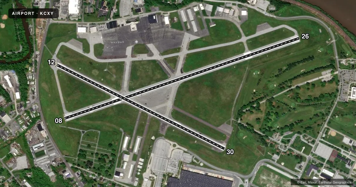
Runways & pattern
Full pagePattern entry · RWY 30
LEFT TRAFFIC| Runway | Heading (°M) | Length | Surface | Traffic |
|---|---|---|---|---|
| 08/26 | 60° / 240° | 5,000 ft | ASPH | 26 R |
| 12/30Favored | 106° / 286° | 3,778 ft | ASPH | 12 R |
Runway end performance
| End | TORA | TODA | ASDA | LDA | VGSI | Approach lights | Obstruction |
|---|---|---|---|---|---|---|---|
| 08 | — | — | — | — | PAPI 4-box right(3°) | MALSR | 76', trees, 1883' from thr, 611' R of cntrln, slope 22 |
| 26 | — | — | — | — | VASI 4-box left(3.1°) | — | 15', pole, 445' from thr, 289' R of cntrln, slope 16 |
| 12 | — | — | — | — | VASI 4-box left(3.9°) | — | 37', trees, 515' from thr, 229' R of cntrln, slope 8 |
| 30 | — | — | — | — | VASI 4-box left(4°) | — | — |
Declared distances in feet. TORA = takeoff run available, TODA = takeoff distance, ASDA = accelerate-stop, LDA = landing distance.
Airport sketch
Runways drawn to scale from FAA survey coordinates, rendered over satellite imagery. Not for navigation.
Approaches & charts
ILS · 1
Services on the field
Fuel grades, oxygen, maintenance, ramp storage and lighting — as declared to the FAA by the airport operator.
Fuel & services
- Fuel
- 100LLA
- Airframe repair
- Major
- Power plant repair
- Major
- Other services
- AVNCS,CHTR,INSTR
Ramp & ground
- Transient storage
- Tie-down
- Hangar
- Landing fee
- No fee published
- Customs
- Not available
- Lighting schedule
- SEE RMK
- Beacon schedule
- SS-SR
- Beacon
- White / Green (civil land)(WG)
- Wind indicator
- Lighted
- Segmented circle
- Yes
Fuel & FBOs
Cheapest 100LL and Jet A on the field and nearby. Always confirm with the FBO before taxi.
Airport notes
Surface conditions, obstructions, local procedures, lighting outages and other notes published with each FAA cycle.
General notes
- PPR FOR HAZARDOUS CARGO.
- ARPT CLSD TO FAR PART 121 ACFT.
- BIRD FLOCKS ON & INVOF ARPT.
- ALERT: ACTIVE TXY PRIOR TO RY 12 RELOCATED THLD, NO T/O OR LNDG ON THIS SURFACE.
- FOR CD WHEN ATCT CLSD CTC HARRISBURG APCH 124.1 OR 800-932-0712.
- USE CTN: DUE TO PROXIMITY & RWY ALMNT, AIRCREWS HAVE MISTAKEN MDT RWY13/31 FOR CXY RWY 12/30 WHICH IS 4 NM W.
Lighting notes
- WHEN ATCT CLSD ACTVT MALSR RWY 08; HIRL RWY 08/26; MIRL RWY 12/30 & TWY LGTS - CTAF.
Runway surface & condition
- 08/26& RWY 12/30, PPR FOR LOADS OVER 100,000 LBS.
Approach & departure obstructions
- 26RWY 26 +7 FT ROAD;GOLF COURSE, +6 FT FENCE EAST AND SOUTH OF RWY END.
- 08RWY 08 PAPI UNUSBL BYD 7 DEGS RIGHT OF CRS.
Other notes
- HIGH TERRAIN SOUTH RWY 12/30. TPA 1500(1153) CONVENTIONAL.
VFR map & nearby airports
VFR sectional. Tap any ICAO chip to open that airport.
Key facts · KCXY
Answer card- ICAO
- KCXY
- Name
- CAPITAL CITY
- Location
- HARRISBURG, PENNSYLVANIA
- Elevation
- 346.7 ft MSL
- Traffic pattern altitude
- 1,846.7 ft MSL (1,500 AGL)
- Control tower
- Towered · 0700-2100
- Total runways
- 2
- Longest runway
- 08/26 · 5,000 ft
- Published ILS approaches
- 1
- Published frequencies
- 12
- Magnetic variation
- 11°
- Current flight rules
- VFR
- Current wind
- 350° at 6 kt
- Favored runway now
- RWY 30
Capital City Airport is in Harrisburg, Pennsylvania. Field elevation is 346.7 ft MSL. The airport has two asphalt runways. The longest is runway 08/26 at 5,000 ft. The tower is open daily from 0700 to 2100. Runway 08 has an ILS approach. Pattern altitude is 1,500 ft AGL, which is 1,846.7 ft MSL for conventional traffic patterns.
Skyport Aviation is on the field. It carries 100LL, Jet A and Jet A Prist. The airport sits in a busy part of central Pennsylvania. Published remarks call out high terrain south of runway 12/30. They also warn that crews have mistaken Middletown’s runway 13/31 for Capital City’s runway 12/30. Middletown is 4 NM west, which makes a careful cross-check on arrival and departure important. Runway 08 PAPI is unusable beyond 7 degrees right of course. When the tower is closed, use the published lighting procedures and contact Harrisburg Approach for clearance delivery if needed. Bird activity is also noted on and near the airport.