METAR & TAF KCWF
Current METAR
Observed 12:45Z
KCWF 271245Z 34003KT 10SM SCT035 28/26 A3000
- Wind
- 340° @ 3 kt
- Visibility
- 10 SM
- Temp / Dew
- 28°C / 26°C
- Altimeter
- 30.00 inHg
- Clouds
- SCT
- Density alt
- 1,481 ft
- Ceiling
- Unlimited
- Rules
- VFR
Airport info & contacts
Manager on record, flight service, ARTCC, attendance schedule and pattern altitude — published by the FAA and refreshed every 28 days.
Location
- From city
- 4 NM E
- VFR sectional
- HOUSTON
- Pattern altitude
- 1,483 ft AGL · 1,500 ft MSL
- ARTCC
- ZHU · HOUSTON
- NOTAM facility
- CWF (NOTAM-D)
Airport manager
- Name
- W. KEVIN MELTON
- Phone
- 337-491-9961
- Address
- 3650 SEN. J. BENNETT JOHNSTON AVE, LAKE CHARLES LA 70615-6849
Flight service · Hours
- FSS DRI
- DE RIDDER1-800-WX-BRIEF
- Attendance
- 0600-2200
Frequencies
Tap any row to copy the frequency to your clipboard.
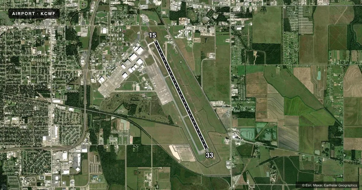
Runways & pattern
Full pagePattern entry · RWY 33
RIGHT TRAFFICRunway end performance
| End | TORA | TODA | ASDA | LDA | VGSI | Approach lights | Obstruction |
|---|---|---|---|---|---|---|---|
| 15 | 10,702' | 10,702' | 10,702' | 10,702' | PAPI 4-box left(3°) | MALSR | — |
| 33 | 10,702' | 10,702' | 10,702' | 10,702' | PAPI 4-box left(3°) | — | — |
Declared distances in feet. TORA = takeoff run available, TODA = takeoff distance, ASDA = accelerate-stop, LDA = landing distance.
Airport sketch
Runways drawn to scale from FAA survey coordinates, rendered over satellite imagery. Not for navigation.
Approaches & charts
ILS · 1
Services on the field
Fuel grades, oxygen, maintenance, ramp storage and lighting — as declared to the FAA by the airport operator.
Fuel & services
- Fuel
- 100LLA1+
- Oxygen (bottled)
- Low pressure
- Oxygen (bulk)
- Not available
- Other services
- CARGO,INSTR,RNTL
Ramp & ground
- Transient storage
- Tie-down
- Hangar
- Landing fee
- No fee published
- Customs
- Not available
- Lighting schedule
- SEE RMK
- Beacon schedule
- SS-SR
- Beacon
- White / Green (civil land)(WG)
- Wind indicator
- Lighted
- Segmented circle
- Yes
Fuel & FBOs
Cheapest 100LL and Jet A on the field and nearby. Always confirm with the FBO before taxi.
Airport notes
Surface conditions, obstructions, local procedures, lighting outages and other notes published with each FAA cycle.
General notes
- INDEX E AVBL WITH 24 HRS NOTICE CALL AMGR 337-491-9961.
- BIRDS ON & INVOF OF ARPT
- WHEN ATCT CLSD, FOR CD CTC HOUSTON ARTCC AT 281-230-5622.
- PPR REQD FOR ACFT / HELO OPS IN THE INDUSTRIAL AREA
- FOR PORT OF ENTRY REQ, CONTACT THE DIR OF OPS VIA CIAA@CHENNAULT.ORG AT LEAST 3 BUS DAYS (M-F) PRIOR TO PLANNED ARR.
- CTC APRT MGR FOR DSGND RAMP SPACE FOR PUB USE.
Lighting notes
- WHEN ATCT CLSD ACTVT MALSR RWY 15; REIL RWY 33; PAPI RWY 15 & 33; HIRL RWY 15/33 - CTAF.
Fuel notes
- 100LLFOR FUEL CALL 337-436-4877. SELF SVC AVBL 24 HRS WITH CREDIT CARD.
Runway surface & condition
- 15/33PCR VALUE: 1449/R/D/W/T
Other notes
- PRVDD ATCT OPNL TO PRVD ATC SVCS PRIOR TO ACFT OPNS.
- 6 HRS PPR FOR ACR OPNS WITH MORE THAN 30 PSGR SEATS CALL AMGR 337-491-9961. ARFF INDEX E AVAILABLE 24/7
- 1AFT HRS CALL 337-433-7766.
VFR map & nearby airports
VFR sectional. Tap any ICAO chip to open that airport.
Key facts · KCWF
Answer card- ICAO
- KCWF
- Name
- CHENNAULT INTL
- Location
- LAKE CHARLES, LOUISIANA
- Elevation
- 16.5 ft MSL
- Traffic pattern altitude
- 1,499.5 ft MSL (1,483 AGL)
- Control tower
- Towered · 0600-2200
- Total runways
- 1
- Longest runway
- 15/33 · 10,702 ft
- Published ILS approaches
- 1
- Published frequencies
- 9
- Magnetic variation
- 0°
- Current flight rules
- VFR
- Current wind
- 340° at 3 kt
- Favored runway now
- RWY 33
Chennault Intl sits in Lake Charles, Louisiana. Field elevation is 16.5 ft MSL. The airport has one runway. Runway 15/33 is 10,702 ft long with concrete pavement. The tower is open from 0600 to 2200. There is one ILS approach on runway 15. Pattern altitude is 1,483 ft AGL. That works out to 1,499.5 ft MSL.
Million Air Lake Charles is on the field. It carries 100LL and Jet A Prist. Self-serve 100LL is available 24 hours with credit card. Birds are reported on and near the airport, so keep a sharp scan on departure and arrival. When the tower is closed, clearance delivery goes through Houston ARTCC. The published remarks also call for prior permission for aircraft and helicopter operations in the industrial area. If you need port of entry handling, contact the director of operations at least 3 business days before planned arrival. For ramp space, contact the airport manager. The field has a long runway and published approach lighting notes for after-hours use, so check the current Chart Supplement and plan your arrival carefully if you are coming in outside tower hours.