METAR & TAF KCLT
Current METAR
Observed 06:52Z
KCLT 280652Z 00000KT 10SM FEW045 BKN250 24/21 A2984 RMK SLP108 T02440211
- Wind
- 000° @ 0 kt
- Visibility
- 10 SM
- Temp / Dew
- 24°C / 21°C
- Altimeter
- 29.84 inHg
- Clouds
- BKN
- Density alt
- 2,107 ft
- Ceiling
- 25,000 ft AGL
- Rules
- VFR
Airport info & contacts
Manager on record, flight service, ARTCC, attendance schedule and pattern altitude — published by the FAA and refreshed every 28 days.
Location
- From city
- 5 NM W
- VFR sectional
- CHARLOTTE
- ARTCC
- ZTL · ATLANTA
- NOTAM facility
- CLT (NOTAM-D)
Airport manager
- Name
- HALEY GENTRY
- Phone
- 704-359-4000
- Address
- 5601 WILKINSON BLVD., CHARLOTTE NC 28208
Flight service · Hours
- FSS RDU
- RALEIGH1-800-WX-BRIEF
- Attendance
- ALL
Frequencies
Tap any row to copy the frequency to your clipboard.
Runways & pattern
Full pagePattern entry · RWY 01R
LEFT TRAFFIC| Runway | Heading (°M) | Length | Surface | Traffic |
|---|---|---|---|---|
| 01R/19L | 349° / 169° | 10,000 ft | CONC | Standard L |
| 01L/19R | 349° / 169° | 9,000 ft | CONC | Standard L |
| 18L/36R | 169° / 349° | 8,676 ft | ASPH-CONC | Standard L |
Runway end performance
| End | TORA | TODA | ASDA | LDA | VGSI | Approach lights | Obstruction |
|---|---|---|---|---|---|---|---|
| 01R | 10,000' | 10,000' | 10,000' | 10,000' | PAPI 4-box left(3°) | ALSF2 | — |
| 19L | 10,000' | 10,000' | 10,000' | 10,000' | PAPI 4-box right(3°) | MALSR | 25', road, 1350' from thr, 425' R of cntrln, slope 46 |
| 01L | 9,000' | 9,000' | 9,000' | 9,000' | PAPI 4-box left(3°) | ALSF2 | — |
| 19R | 9,000' | 9,000' | 9,000' | 9,000' | PAPI 4-box right(2.8°) | ALSF2 | — |
| 18L | 8,676' | 8,676' | 8,676' | 8,676' | PAPI 4-box left(3°) | — | 19', rr, 523' from thr, 0' R of cntrln, slope 17 |
| 36R | 8,676' | 8,676' | 8,390' | 8,390' | PAPI 4-box right(3°) | ALSF2 | — |
Declared distances in feet. TORA = takeoff run available, TODA = takeoff distance, ASDA = accelerate-stop, LDA = landing distance.
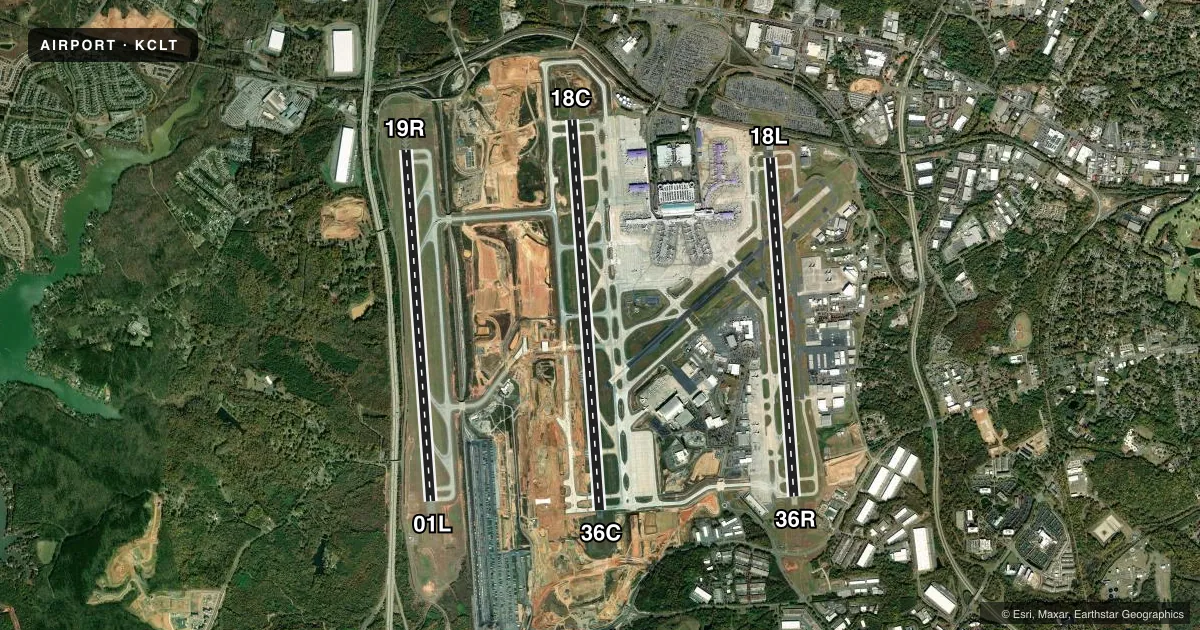
Airport sketch
Runways drawn to scale from FAA survey coordinates, rendered over satellite imagery. Not for navigation.
Approaches & charts
ILS · 6
Services on the field
Fuel grades, oxygen, maintenance, ramp storage and lighting — as declared to the FAA by the airport operator.
Fuel & services
- Fuel
- 100LLAA++
- Oxygen (bottled)
- Not available
- Oxygen (bulk)
- HIGH/LOW
- Airframe repair
- Major
- Power plant repair
- Major
- Other services
- AFRT,AMB,AVNCS,CARGO,CHTR,RNTL,SALES,SURV
Ramp & ground
- Transient storage
- Tie-down
- Landing fee
- No fee published
- Customs
- Not available
- Lighting schedule
- SS-SR
- Beacon schedule
- SS-SR
- Beacon
- White / Green (civil land)(WG)
- Wind indicator
- Lighted
- Segmented circle
- No
Fuel & FBOs
Cheapest 100LL and Jet A on the field and nearby. Always confirm with the FBO before taxi.
Airport notes
Surface conditions, obstructions, local procedures, lighting outages and other notes published with each FAA cycle.
General notes
- RY SFC COND INFO DURG DUTY HRS PHONE ANG OPS 704-391-9177 OR AIRBORNE 292.25.
- BE ALERT FOR FLOCKS OF MIGRATORY BIRDS ON & INVOF ARPT.
- MILITARY: ANG: CTC COMD POST 30 MIN PRIOR LDG. AMOPS/COMD POST - 292.25 (CALL NEWSREEL).
- SUCCESSIVE OR SIMULTANEOUS DEPARTURES FROM RWY 18L AND RWY 19L ARE APPROVED WITH COURSE DIVERGENCE BEGINNING NO FURTHER THAN 4 MILES FROM END OF RWY.
- RWY STATUS LGTS IN OPR.
- TWY C4 AND C6: WHEN TAXIING AIRCRAFT WITH COCKPIT TO MAIN GEAR DISTANCE GREATER THAN 90 FT, PILOT MUST PERFORM JUDGEMENTAL OVERSTEERING INSTEAD OF COCKPIT OVER CENTERLINE STEERING.
- GROUP IV ACFT WITH A WINGSPAN GTR THAN 118 FT ARE PROHIBITED FM EXITING RWY 18L/36R AT TWY C10.
- TWY C10 UNUSBL FOR TXG ONTO RWY 18L/36R.
- CLT RAMP, NON-MOVMT AREA, IS CTLD RAMP; CTC RAMP CTL PRIOR TO ENTERING.
- GROUP III ACFT WITH A WINGSPAN GTR THAN 79 FT ARE PROHIBITED FM MAKING A NBND TURN ONTO TWY C WHEN TAXIING WB ON TWY A.
- TWY D, RESTRICTED TO 15 MPH OR LESS WITH WINGSPAN 171 FT AND GREATER.
- GROUP III ACFT WITH A WINGSPAN GTR THAN 79 FT ARE PROHIBITED FM MAKING A SBND TURN ONTO TWY C WHEN TAXIING NWBND ON TWY R.
- TWY C FROM THE APCH OF RWY 18L TO TWY J AND TWY M FROM THE APRON TO RWY 18L/36R RSTRD TO 15 MPH OR LESS WITH WINGSPAN 171 FT AND GTR.
- GROUP VI ACFT WITH A WINGSPAN GTR THAN 214 FT (65M) ARE PROHIBITED ON TWY M BETWEEN THE TRML RAMP AND TWY C, AS WELL AS TWY C NORTH OF TWY M.
- ALL ACFT ARE PROHIBITED FM EXITING RWY 36R SEBD AT TWY R.
- TRML RAMP ORANGE TXL FROM SPOT 1W TO SPOT 27E MAX WINGSPAN 118 FT.
- TRML RAMP BLUE TXL FROM SPOT 1E TO SPOT 27W MAX WINGSPAN 118 FT.
- TRML RAMP ORANGE TXL FROM SPOT 29E TO SPOT 34N MAX WINGSPAN 82 FT.
- TRML RAMP BLUE TXL AT SPOT 28S BTN CONCOURSE D & E ALLEY MAX WINGSPAN 118 FT.
- TRML RAMP BLUE TXL FROM SPOT 26N TO SPOT 27W MAX WINGSPAN 118 FT.
- TRML RAMP ORANGE TXL AT SPOT 28N BETWEEN CONCOURSE D & E ALLEY MAX WINGSPAN 94 FT.
- ACFT WITH WINGSPAN GTR THAN 118 FT USE JUDGMENTAL OVERSTEER INSTEAD OF COCKPIT OVER CNTRLN STEERING ENTERING AND EXITING RWY 18L/36R.
Fuel notes
- 100LLA++(MIL), 100 & O-156 AVBL.
Runway surface & condition
- 01L/19RPCR VALUE: 627/R/C/W/T
- 01R/19LPCR VALUE: 1009/R/C/W/T
- 18L/36RPCR VALUE: 1076/R/D/W/T
- 18L/36RENGINEERED MATERIALS ARRESTING GEAR SYSTEM (EMAS) 255 FT IN LENGTH BY 170 FT IN WIDTH AT THE DEPARTURE END OF RWY 36R.
Other notes
- ARPT EXISTED PRIOR TO 1958.
- LIQUID OXYGEN ALSO AVBL.
- 1J8 FUEL ALSO AVBL.
VFR map & nearby airports
VFR sectional. Tap any ICAO chip to open that airport.
Key facts · KCLT
Answer card- ICAO
- KCLT
- Name
- CHARLOTTE/DOUGLAS INTL
- Location
- CHARLOTTE, NORTH CAROLINA
- Elevation
- 747.9 ft MSL
- Traffic pattern altitude
- 1,747.9 ft MSL (1,000 AGL)
- Control tower
- Towered · 24
- Total runways
- 3
- Longest runway
- 01R/19L · 10,000 ft
- Published ILS approaches
- 6
- Published frequencies
- 29
- Magnetic variation
- 7°
- Current flight rules
- VFR
- Current wind
- 000° at 0 kt
- Favored runway now
- –
Charlotte/Douglas Intl is in Charlotte, North Carolina. Field elevation is 747.9 ft MSL. The airport has 3 runways. The longest is 18C/36C at 10,000 ft. The tower is open 24 hours. There are 6 ILS approaches serving all runway ends. Pattern altitude is not published, so use the standard 1,000 ft AGL for light piston traffic unless ATC gives you something different.
Modern Aviation is on the field. It carries 100LL, Jet A and Jet A Prist. J8 fuel is also noted in the published remarks. This is a busy Class B airport with heavy airline and cargo traffic. Expect close attention to taxi instructions and runway assignment. The published remarks also call out taxiway and ramp wingspan limits in some areas. Large aircraft should pay close attention to those restrictions. Runway surface condition information is available by phone through Air National Guard operations during duty hours or airborne on 292.2. If you are new to the field, brief the taxi plan before startup. Be ready for a fast pace on the ground.