METAR & TAF KCFO
Current METAR
Observed 07:55Z
KCFO 280755Z AUTO 00000KT 10SM CLR 24/16 A3016 RMK AO2 LTG DSNT SE T02360161
- Wind
- 000° @ 0 kt
- Visibility
- 10 SM
- Temp / Dew
- 24°C / 16°C
- Altimeter
- 30.16 inHg
- Clouds
- CLR
- Density alt
- 7,621 ft
- Ceiling
- Unlimited
- Rules
- VFR
Airport info & contacts
Manager on record, flight service, ARTCC, attendance schedule and pattern altitude — published by the FAA and refreshed every 28 days.
Location
- From city
- 19 NM E
- VFR sectional
- DENVER
- Pattern altitude
- 988 ft AGL · 6,503 ft MSL
- ARTCC
- ZDV · DENVER
- NOTAM facility
- CFO (NOTAM-D)
Airport manager
- Name
- JEFF KLOSKA
- Phone
- 303-261-9100
- Address
- 5200 FRONT RANGE PKWY, WATKINS CO 80137
Flight service · Hours
- FSS DEN
- DENVER1-800-WX-BRIEF
- Attendance
- 0700-2100
Frequencies
Tap any row to copy the frequency to your clipboard.
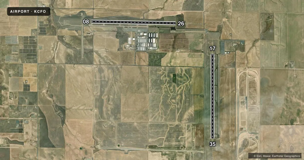
Runways & pattern
Full pagePattern entry · RWY 08
RIGHT TRAFFIC| Runway | Heading (°M) | Length | Surface | Traffic |
|---|---|---|---|---|
| 08/26 | 83° / 263° | 8,002 ft | ASPH | 08 R |
| 17/35 | 172° / 352° | 8,000 ft | ASPH | 35 R |
Runway end performance
| End | TORA | TODA | ASDA | LDA | VGSI | Approach lights | Obstruction |
|---|---|---|---|---|---|---|---|
| 08 | — | — | — | — | PAPI 2-box left(3°) | — | — |
| 26 | — | — | — | — | PAPI 2-box left(3°) | MALSR | — |
| 17 | — | — | — | — | PAPI 4-box left(3°) | — | — |
| 35 | — | — | — | — | PAPI 4-box left(3°) | MALSR | 74', pline, 3833' from thr, 593' R of cntrln, slope 49 |
Declared distances in feet. TORA = takeoff run available, TODA = takeoff distance, ASDA = accelerate-stop, LDA = landing distance.
Airport sketch
Runways drawn to scale from FAA survey coordinates, rendered over satellite imagery. Not for navigation.
Approaches & charts
ILS · 3
Services on the field
Fuel grades, oxygen, maintenance, ramp storage and lighting — as declared to the FAA by the airport operator.
Fuel & services
- Fuel
- 100LLA
- Oxygen (bottled)
- Not available
- Oxygen (bulk)
- HIGH/LOW
- Airframe repair
- Major
- Power plant repair
- Major
- Other services
- AGRI,AVNCS,CHTR,INSTR,RNTL,SALES
Ramp & ground
- Transient storage
- Tie-down
- Hangar
- Landing fee
- No fee published
- Lighting schedule
- SEE RMK
- Beacon schedule
- SS-SR
- Beacon
- White / Green (civil land)(WG)
- Wind indicator
- Lighted
- Segmented circle
- Yes
Fuel & FBOs
Cheapest 100LL and Jet A on the field and nearby. Always confirm with the FBO before taxi.
Airport notes
Surface conditions, obstructions, local procedures, lighting outages and other notes published with each FAA cycle.
General notes
- TWY EDGE LIGHTS ALONG A, B, C, D, & E.
- NOISE SENSITIVE AREAS SE, S & SW OF ARPT. AVOID FLT BLW 1000 FT OVR POPULATED AREAS.
- CTN: USAF TRNG ACT INVOF COLORADO SPRINGS & PUEBLO ARPT.
Lighting notes
- ACTVT MALSR RWY 26 & 35; REIL RWY 08 & 17; PAPI RWY 08 & 26, 17 & 35; HIRL RWY 08/26; MIRL RWY 17/35 - CTAF.
Fuel notes
- 100LL100LL SELF SVC AVBL H24 WITH CREDIT CARD.
Other notes
- 1AFT HR SVC - AMGR.
VFR map & nearby airports
VFR sectional. Tap any ICAO chip to open that airport.
Key facts · KCFO
Answer card- ICAO
- KCFO
- Name
- COLORADO AIR AND SPACE PORT
- Location
- DENVER, COLORADO
- Elevation
- 5,515.2 ft MSL
- Traffic pattern altitude
- 6,503.2 ft MSL (988 AGL)
- Control tower
- Towered · 0700-2100
- Total runways
- 2
- Longest runway
- 08/26 · 8,002 ft
- Published ILS approaches
- 3
- Published frequencies
- 9
- Magnetic variation
- 8°
- Current flight rules
- VFR
- Current wind
- 000° at 0 kt
- Favored runway now
- –
Colorado Air and Space Port is in Denver, Colorado. Field elevation is 5,515.2 ft MSL. The airport has 2 asphalt runways. The longest is runway 08/26 at 8,002 ft. The tower is open from 0700 to 2100. Pattern altitude is 988 ft AGL, which is 6,503.2 ft MSL.
KCFO has 3 ILS approaches. They serve runway ends 17, 26 and 35. The field sits at high elevation, so performance planning matters on warm days. Expect density altitude to be a real factor. The airport also notes noise sensitive areas southeast, south and southwest of the field. Avoid flight below 1,000 ft over populated areas. The airport publishes 24-hour self-serve 100LL with credit card. After-hours service is handled by the airport manager.
The on-field FBO is Colorado Air & Space Port. It carries 100LL and Jet A. Taxiway edge lights are installed on taxiways A through E. Runway 26 and 35 have MALSR. Runway end identifier lights are on runways 08 and 17. PAPI is installed on 08, 26, 17 and 35. Use the common traffic advisory frequency when operating outside tower hours. There is also military training activity in the vicinity of Colorado Springs and Pueblo airports. Keep an eye on the bigger picture when routing nearby.