METAR & TAF KBWI
Current METAR
Observed 06:54Z
KBWI 280654Z 21003KT 10SM FEW100 BKN210 BKN250 23/21 A2977 RMK AO2 SLP078 T02330211 $
- Wind
- 210° @ 3 kt
- Visibility
- 10 SM
- Temp / Dew
- 23°C / 21°C
- Altimeter
- 29.77 inHg
- Clouds
- BKN
- Density alt
- 1,324 ft
- Ceiling
- 21,000 ft AGL
- Rules
- VFR
Airport info & contacts
Manager on record, flight service, ARTCC, attendance schedule and pattern altitude — published by the FAA and refreshed every 28 days.
Location
- From city
- 9 NM S
- VFR sectional
- WASHINGTON
- ARTCC
- ZDC · WASHINGTON
- NOTAM facility
- BWI (NOTAM-D)
Airport manager
- Name
- GREGORY SOLEK
- Phone
- 410-859-7018
- Address
- AIRPORT OPERATIONS, PO BOX 8766, BWI AIRPORT MD 21240-0766
Flight service · Hours
- FSS DCA
- LEESBURG1-800-WX-BRIEF
- Attendance
- ALL
Frequencies
Tap any row to copy the frequency to your clipboard.
Runways & pattern
Full pagePattern entry · RWY 28
LEFT TRAFFIC| Runway | Heading (°M) | Length | Surface | Traffic |
|---|---|---|---|---|
| 10/28Favored | 83° / 263° | 10,503 ft | ASPH | Standard L |
| 15R/33L | 133° / 313° | 9,501 ft | ASPH | Standard L |
| 15L/33R | 133° / 313° | 5,000 ft | ASPH | Standard L |
Runway end performance
| End | TORA | TODA | ASDA | LDA | VGSI | Approach lights | Obstruction |
|---|---|---|---|---|---|---|---|
| 10 | 10,503' | 10,503' | 10,503' | 9,953' | PAPI 4-box right(3°) | ALSF2 | 35', tree, 1606' from thr, 305' R of cntrln, slope 40 |
| 28 | 10,503' | 10,503' | 10,503' | 9,803' | PAPI 4-box left(3°) | MALSR | 31', tree, 1230' from thr, 425' R of cntrln, slope 33 |
| 15R | 9,501' | 9,501' | 8,601' | 8,301' | PAPI 4-box right(3°) | MALSR | 126', ant, 4724' from thr, 908' R of cntrln, slope 35 |
| 33L | 9,501' | 9,501' | 8,801' | 8,301' | PAPI 4-box left(3°) | MALSR | 154', tower, 7460' from thr, 906' R of cntrln, slope 47 |
| 15L | 5,000' | 5,000' | 5,000' | 5,000' | PAPI 4-box left(3°) | — | 31', pole, 1120' from thr, 615' R of cntrln, slope 30 |
| 33R | 5,000' | 5,000' | 5,000' | 5,000' | PAPI 4-box left(3°) | MALSR | 39', tree, 1470' from thr, 585' R of cntrln, slope 32 |
Declared distances in feet. TORA = takeoff run available, TODA = takeoff distance, ASDA = accelerate-stop, LDA = landing distance.
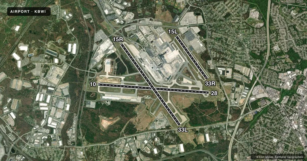
Airport sketch
Runways drawn to scale from FAA survey coordinates, rendered over satellite imagery. Not for navigation.
Approaches & charts
ILS · 6
Services on the field
Fuel grades, oxygen, maintenance, ramp storage and lighting — as declared to the FAA by the airport operator.
Fuel & services
- Fuel
- 100LLA
- Oxygen (bottled)
- HIGH/LOW
- Oxygen (bulk)
- HIGH/LOW
- Airframe repair
- Major
- Power plant repair
- Major
- Other services
- AFRT,CARGO,CHTR,INSTR,RNTL,SALES
Ramp & ground
- Transient storage
- Tie-down
- Hangar
- Landing fee
- Yes
- Customs
- Not available
- Beacon schedule
- SS-SR
- Beacon
- White / Green (civil land)(WG)
- Wind indicator
- Lighted
- Segmented circle
- Yes
Fuel & FBOs
Cheapest 100LL and Jet A on the field and nearby. Always confirm with the FBO before taxi.
Airport notes
Surface conditions, obstructions, local procedures, lighting outages and other notes published with each FAA cycle.
General notes
- PRACTICE LNDG & APCH BY TURBO-PWRD ACFT PROHIBITED 2200-0600; PRACTICE LNDG & TKOF BY B-747 ACFT PROHIBITED RWY 15R/33L.
- CONT MOWING OPERATIONS ADJ ALL RWYS & TWYS - APR THRU NOV.
- NO APRON PARKING FOR UNSKED ACR.
- DEER & BIRDS OCNLLY ON & INVOF ARPT.
- DISTRACTING LGTS (GOLF DRIVING RANGE) RIGHT SIDE EXTDD CNTRLN RWY 33L FM AER TO 1/4 MI FINAL.
- NOISE ABATEMENT PROCEDURES IN EFFECT - RSTRN FOR RWY 15L/33R EXCEPT FOR EMERG OR MERCY FLIGHTS CTC AMGR FOR INFO.
- MAJOR CONSTR ON ARPT DLY; ACFT MOV & PRKG AREAS SUBJECT TO SHORT NOTICE CHANGE/CLOSURE. FOR CURRENT INFO PHONE BWI OPNS CNTR 410-859-7018.
- ACFT ON VISUAL APCHS EXPECT TO MAINTAIN 3000 FT UNTIL 10 DME FM BAL VORTAC; DEP ACFT SHOULD EXPECT TURNS BASED ON BALTIMORE DME.
- TAXIING PROHIBITED BTN CONCOURSE C & ADJ BLDG STRUCTURE SW OF CONCOURSE C. ACCESS TO GATE C12 MUST BE VIA TWY A.
- TWY "S", SOUTH OF TWY "P", RSTRD TO ACFT 60000 LBS & LESS.
- GA ACFT CTC 129.0 PRIOR TO ARR AT GA RAMP FOR SCTY PURPOSES.
- TAXILANES 'T-1' & "H" RSTRD TO GROUP III ACFT WITH MAX WINGSPAN OF 118 FEET.
- CONCOURSE A ALT DEICING AREA IS RSTRD TO B737-800 SIZE ACFT WITH WINGLETS OR SMLR ON SPOTS 6, 7 AND 8.
- RWY 28 DE-ICE PAD LANE 1 RSTRD TO ACFT WITH WINGSPAN 171 FT OR LESS, LANE 2 RSTRD TO ACFT WITH WINGSPAN 135 FT OR LESS, LANE 3 IS USED BY LARGE ACFT MAX WINGSPAN 215 FT AND WHEN IN USE- LANES 2 AND 4 ARE UNAVBL. LANES 4, 5 & 6 ARE RSTRD TO ACFT WINGSPAN 135 FT OR LESS.
- TWY T BTN TWY H AND TWY E RSTD TO GROUP IV ACFT WITH WINGSPAN LESS THAN 171 FT. TWY T BTN TWY E AND TWY B RSTRD TO GROUP V ACFT WITH WINGSPAN LESS THAN 214 FT; WHEN GROUP V ACFT ARE ON TWY T, TWY A IS RSTRD TO MAX WINGSPANS OF 110 FT.
- DUAL PARALLEL TAXILANES HAVE BEEN ADDED TO THE 'D'/'E' ALLEYWAY; TAXILANE 'N' AND TAXILANE 'N1'. TAXILANE 'N' IS DESIGNATED A "GROUP V" TAXILANE WITH MAX WINGSPAN OF 213 FT. TAXILANE 'N1' IS DESIGNATED A "GROUP IV" TAXILANE WITH MAX WINGSPAN OF 170 FT.
- TWY 'A' IS RSTRD TO GROUP IV ACFT WINGSPAN 171 FT OR LESS.
- RWY LEN AVBL FOR RWY 28 DEPS FM TWY U1 IS 9802 FT.
- RWY STATUS LGTS IN OPN.
- ACFT DEPARTING RWY 28 EXP DEP FM TWY U1.
- DURING ATC ZERO EVENTS, UNICOM 119.4.
- UNICOM 119.4.
- RWY 15R DEICE PAD PSNS 1 THRU 5 RSTRD TO ACFT WITH WINGSPAN 117 FT 6 INS OR LESS.
Runway surface & condition
- 10/28PCR VALUE: 759/F/A/X/T
- 15L/33RPCR VALUE: 269/F/A/X/T
- 15R/33LPCR VALUE: 759/F/A/X/T
Approach & departure obstructions
- 33LRWY 33L +2 FT ROAD 170 FT FROM RWY END 500 FT LEFT.
- 10MIDFIELD RVR SENSOR SHARED BY RWY 10/28 & RWY 15R/33L.
- 10APCH RATIO 50:1 TO DSPLCD THR.
- 28APCH RATIO 50:1 TO DSPLCD THR.
Other notes
- SURVEYED.
VFR map & nearby airports
VFR sectional. Tap any ICAO chip to open that airport.
Key facts · KBWI
Answer card- ICAO
- KBWI
- Name
- BALTIMORE/WASHINGTON INTL THURGOOD MARSHALL
- Location
- BALTIMORE, MARYLAND
- Elevation
- 143.4 ft MSL
- Traffic pattern altitude
- 1,143.4 ft MSL (1,000 AGL)
- Control tower
- Towered · 24
- Total runways
- 3
- Longest runway
- 10/28 · 10,503 ft
- Published ILS approaches
- 6
- Published frequencies
- 33
- Magnetic variation
- 11°
- Current flight rules
- VFR
- Current wind
- 210° at 3 kt
- Favored runway now
- RWY 28
KBWI sits in Baltimore, Maryland. Field elevation is 143.4 ft MSL. The airport has 3 asphalt runways. The longest is runway 10/28 at 10,503 ft. The tower is open 24 hours. There are 6 ILS approaches available. Pattern altitude is not published, so plan on the standard 1,000 ft AGL for light piston traffic unless the current Chart Supplement says otherwise.
Signature Aviation is on the field. It carries 100LL and Jet A. Call ahead if you need current ramp details or fuel availability. This is busy Class B airspace, so expect a structured arrival and departure flow. The published remarks also matter here. Continuous mowing happens near the runways and taxiways from April through November. Taxiway restrictions apply for larger wingspans. Visual arrivals are expected to stay at 3,000 ft until 10 DME from Baltimore VORTAC. Noise abatement procedures are in effect. Restrictions apply on runway 15L/33R except for emergency or mercy flights. If you are planning a first trip in, review the current Chart Supplement and brief the taxi plan carefully before you start down.