METAR & TAF KBVY
Current METAR
Observed 16:53Z
KBVY 271653Z 11005KT 10SM CLR 26/13 A2983 RMK AO2 SLP094 T02560133
- Wind
- 110° @ 5 kt
- Visibility
- 10 SM
- Temp / Dew
- 26°C / 13°C
- Altimeter
- 29.83 inHg
- Clouds
- CLR
- Density alt
- 1,565 ft
- Ceiling
- Unlimited
- Rules
- VFR
Airport info & contacts
Manager on record, flight service, ARTCC, attendance schedule and pattern altitude — published by the FAA and refreshed every 28 days.
Location
- From city
- 3 NM NW
- VFR sectional
- NEW YORK
- ARTCC
- ZBW · BOSTON
- NOTAM facility
- BVY (NOTAM-D)
Airport manager
- Name
- GABRIEL HANAFIN
- Phone
- 978-921-6072
- Address
- 50 LP HENDERSON RD, BEVERLY MA 01915
Flight service · Hours
- FSS BDR
- BRIDGEPORT1-800-WX-BRIEF
- Attendance
- 0830-1630
Frequencies
Tap any row to copy the frequency to your clipboard.
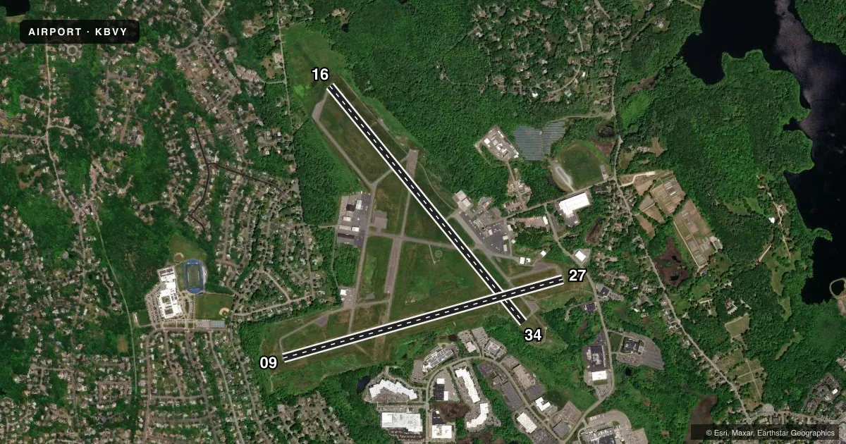
Runways & pattern
Full pagePattern entry · RWY 16
LEFT TRAFFIC| Runway | Heading (°M) | Length | Surface | Traffic |
|---|---|---|---|---|
| 16/34Favored | 125° / 305° | 5,001 ft | ASPH | Standard L |
| 09/27 | 58° / 238° | 4,755 ft | ASPH | Standard L |
Runway end performance
| End | TORA | TODA | ASDA | LDA | VGSI | Approach lights | Obstruction |
|---|---|---|---|---|---|---|---|
| 16 | — | — | — | — | PAPI 4-box left(3.5°) | MALS | 32', trees, 1000' from thr, 125' R of cntrln, slope 25 |
| 09 | — | — | — | — | PAPI 4-box left(3°) | — | 15', tree, 300' from thr, 150' R of cntrln, slope 6 |
| 27 | — | — | — | — | PAPI 4-box left(3.22°) | — | 22', trees, 396' from thr, 125' R of cntrln, slope 8 |
Declared distances in feet. TORA = takeoff run available, TODA = takeoff distance, ASDA = accelerate-stop, LDA = landing distance.
Airport sketch
Runways drawn to scale from FAA survey coordinates, rendered over satellite imagery. Not for navigation.
Approaches & charts
Services on the field
Fuel grades, oxygen, maintenance, ramp storage and lighting — as declared to the FAA by the airport operator.
Fuel & services
- Fuel
- 100LLAA+
- Oxygen (bottled)
- HIGH/LOW
- Airframe repair
- Major
- Power plant repair
- Major
- Other services
- AVNCS,INSTR,RNTL
Ramp & ground
- Transient storage
- Tie-down
- Hangar
- Customs
- Not available
- Lighting schedule
- SEE RMK
- Beacon schedule
- SS-SR
- Beacon
- White / Green (civil land)(WG)
- Wind indicator
- Yes
- Segmented circle
- Yes
Fuel & FBOs
Cheapest 100LL and Jet A on the field and nearby. Always confirm with the FBO before taxi.
Airport notes
Surface conditions, obstructions, local procedures, lighting outages and other notes published with each FAA cycle.
General notes
- BIRDS FQTLY ON OR INVOF ARPT; OCNL DEER OR COYOTE ON RWY.
- WHEN TWR NOT OPN, CLOSE FP WITH BOS APCH - 121.6.
- OVNGT PRKG FEE.
- NOISE ABATEMENT PROCS IN EFCT CTC AMGR 978-921-6072.
- ALL ARR/DEP ACFT FLW MANUFACTURER'S RCMDD PROCS FOR QUIET OPNS & MNM NOISE.
- NOISE SENSITIVE ARPT - VOLUNTARY COMPLIANCE REQD OF ALL ACFT EXCEEDING 75DB TO NOT LND/DEPART ARPT 2300-0700.
- NO TIEDOWN ROPES ON PUBLIC TSNT PRKG.
- NOISE SENSITIVE AREA OFF THE DER 27 TO THE W, SW, & S AND OFF THE DER 34 TO THE NW.
- E RAMP TSNT SPACES: SPACE NRS 15, 16 & 17 ONLY.
- FUEL, PRKG CTC FBO 129.725 OR 978-774-2070.
- RWY 16 IS THE PREF CALM WIND RWY.
- RWY 16/34: DUE TO HUMP AT MIDPT, OPPOSITE ENDS OF THE RWY NOT VSB AT GND LEVEL.
- LDG FEES FOR TSNT ACFT.
- FLD COND NOT MNT 0200-1200Z++ 15 MAY-31 OCT; 0100-1200Z++ 01 NOV-14 MAY.
- NO ULTRALIGHT OR BANNER TOWING ALLOWED.
- FUEL SVC 1030-2330Z++, AFTER HRS REQ ONLY ON 978-774-2070.
Lighting notes
- WHEN TWR CLSD ACTVT MALS RWY 16; REIL RWY 34; PAPI RWY 16, 09, & 27; MIRL RWY 09/27 & 16/34 - CTAF.
Fuel notes
- 100LLFUEL SVC 1030-2330Z++; AFT HRS REQ ONLY CALL 978-774-2070.
Runway surface & condition
- 09/27PCR VALUE: 200/F/B/X/T
- 16/34PCR VALUE: 200/F/B/X/T
Approach & departure obstructions
- 16NON-STD MALS - 800 FT.
- 1630:1 TO DTHR.
- 2750:1 TO DTHR.
Other notes
- FILED FOR RECORD PURPOSES ONLY.
VFR map & nearby airports
VFR sectional. Tap any ICAO chip to open that airport.
Key facts · KBVY
Answer card- ICAO
- KBVY
- Name
- BEVERLY RGNL
- Location
- BEVERLY, MASSACHUSETTS
- Elevation
- 107.2 ft MSL
- Traffic pattern altitude
- 1,107.2 ft MSL (1,000 AGL)
- Control tower
- Towered · 0700-2100 15 MAY-31 OCT; 0700-2000 01 NOV-14 MAY
- Total runways
- 2
- Longest runway
- 16/34 · 5,001 ft
- Published ILS approaches
- 0
- Published frequencies
- 7
- Magnetic variation
- 16°
- Current flight rules
- VFR
- Current wind
- 110° at 5 kt
- Favored runway now
- RWY 16
KBVY is Beverly Rgnl in Beverly, Massachusetts. The field sits at 107.2 ft MSL on the North Shore near Boston. It has two asphalt runways. The longest is 5,001 ft on 16/34. Runway 09/27 is 4,755 ft.
The airport is towered. Tower hours are 0700-2100 Z from 15 May through 31 Oct. Hours are 0700-2000 Z from 01 Nov through 14 May. No ILS approaches are published here. Pattern altitude is not published. Use the standard 1,000 ft AGL for light piston traffic unless the current FAA Chart Supplement says otherwise.
FlightLevel Aviation is on the field. It carries 100LL, Jet A and Jet A Prist. Fuel service is available from 1030 to 2330 Z and later. After-hours service is by request only at 978-774-2070. Expect active local traffic. Birds are frequently on or near the airport. Deer or coyote can also be on the runway. Runway 16 is the preferred calm wind runway. Runway 16/34 has a hump at midpoint. The opposite ends are not visible from the ground. When the tower is closed, use the published lighting activation procedures. Close your flight plan with Boston Approach on 121.6.