METAR & TAF KBRO
Current METAR
Observed 18:53Z
KBRO 271853Z 14016G27KT 10SM CLR 36/21 A2994 RMK AO2 PK WND 11028/1835 SLP136 T03610211
- Wind
- 140° @ 16G27 kt
- Visibility
- 10 SM
- Temp / Dew
- 36°C / 21°C
- Altimeter
- 29.94 inHg
- Clouds
- CLR
- Density alt
- 2,523 ft
- Ceiling
- Unlimited
- Rules
- VFR
Airport info & contacts
Manager on record, flight service, ARTCC, attendance schedule and pattern altitude — published by the FAA and refreshed every 28 days.
Location
- From city
- 4 NM E
- VFR sectional
- BROWNSVILLE
- ARTCC
- ZHU · HOUSTON
- NOTAM facility
- BRO (NOTAM-D)
Airport manager
- Name
- FAISAL KHALIFA- INTERIM AIRPORT DIR
- Phone
- 956-459-1811
- Address
- 700 AMELIA EARHART, BROWNSVILLE TX 78521-5721
Flight service · Hours
- FSS SJT
- SAN ANGELO1-800-WX-BRIEF
- Attendance
- ALL
Frequencies
Tap any row to copy the frequency to your clipboard.
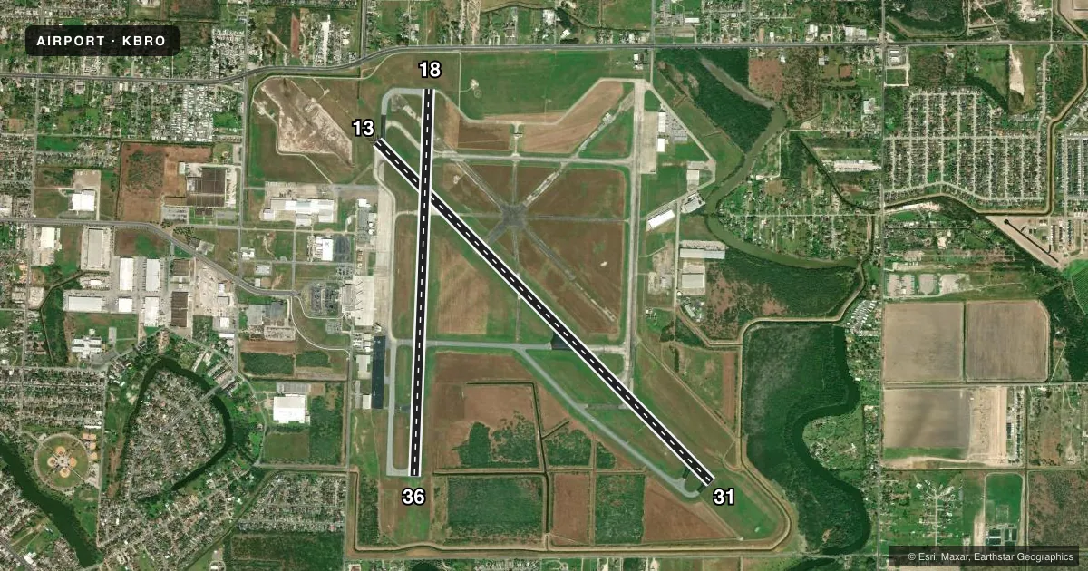
Runways & pattern
Full pagePattern entry · RWY 13
LEFT TRAFFIC| Runway | Heading (°M) | Length | Surface | Traffic |
|---|---|---|---|---|
| 13/31Favored | 132° / 312° | 7,399 ft | ASPH | Standard L |
| 18/36 | 179° / 359° | 6,000 ft | ASPH | Standard L |
Runway end performance
| End | TORA | TODA | ASDA | LDA | VGSI | Approach lights | Obstruction |
|---|---|---|---|---|---|---|---|
| 13 | 7,399' | 7,399' | 7,399' | 7,399' | — | MALSR | 31', tree, 1224' from thr, 369' R of cntrln, slope 33 |
| 31 | 7,399' | 7,399' | 7,399' | 7,399' | PAPI 4-box left(3°) | — | 24', tree, 751' from thr, 611' R of cntrln, slope 22 |
| 18 | 6,000' | 6,000' | 6,000' | 5,810' | PAPI 4-box left(3°) | — | 37', tree, 722' from thr, 140' R of cntrln, slope 14 |
| 36 | 5,532' | 5,532' | 5,532' | 5,532' | VASI 4-box left(3°) | — | 30', tree, 660' from thr, 312' R of cntrln, slope 15 |
Declared distances in feet. TORA = takeoff run available, TODA = takeoff distance, ASDA = accelerate-stop, LDA = landing distance.
Airport sketch
Runways drawn to scale from FAA survey coordinates, rendered over satellite imagery. Not for navigation.
Approaches & charts
ILS · 1
Services on the field
Fuel grades, oxygen, maintenance, ramp storage and lighting — as declared to the FAA by the airport operator.
Fuel & services
- Fuel
- 100LLA
- Oxygen (bottled)
- High pressure
- Oxygen (bulk)
- High pressure
- Airframe repair
- Major
- Power plant repair
- Major
- Other services
- AFRT,AVNCS,CARGO,CHTR,INSTR,RNTL,SALES
Ramp & ground
- Transient storage
- Tie-down
- Hangar
- Landing fee
- Yes
- Customs
- Available
- Lighting schedule
- SEE RMK
- Beacon schedule
- SS-SR
- Beacon
- White / Green (civil land)(WG)
- Wind indicator
- Lighted
- Segmented circle
- Yes
Fuel & FBOs
Cheapest 100LL and Jet A on the field and nearby. Always confirm with the FBO before taxi.
Airport notes
Surface conditions, obstructions, local procedures, lighting outages and other notes published with each FAA cycle.
General notes
- FLIGHT NOTIFICATION SERVICE (ADCUS) AVAILABLE.
- LGTD OIL DERRICKS LCTN APRXLY 5 NM NE MAX 500 FT AGL.
- BIRDS ON & INVOF ARPT.
- FOR CD WHEN ATCT IS CLSD CTC CRP APCH AT 361-299-4230.
- TXY J NORTH OF TXY H OPEN TO TFC UNDER 12500 LBS.
- FOR CUST AND BDR PROTECTION SVCS CTC: 956-547-5760 DLY 0800-2400; KBRO.GAP@CBP.DHS.GOV. AFT HRS: 956-983-5704, 956-982-3653; BROWNSVILLEOPSCENTER@CBP.DHS.GOV.
Lighting notes
- DUSK-DAWN. WHEN ATCT CLSD ACTVT MALSR RWY 13 - CTAF.
Runway surface & condition
- 13/31PCR VALUE: 660/F/B/X/T
- 18/36PCR VALUE: 540/F/D/X/T
Other notes
- WHEN ATCT CLSD REQ ARFF ASSISTANCE THRU HOUSTON ARTCC OR FLT SVC. PPR 24 HRS FOR UNSKED ACR OPNS WITH MORE THAN 30 PSGR SEATS CALL AMGR 956-542-4373.
- 1FOR ACFT SVC CALL 956-542-5852 OR 956-542-9111.
- MANAGERINTERIM DIRECTOR OF AVIATION.
VFR map & nearby airports
VFR sectional. Tap any ICAO chip to open that airport.
Key facts · KBRO
Answer card- ICAO
- KBRO
- Name
- BROWNSVILLE/SOUTH PADRE ISLAND INTL
- Location
- BROWNSVILLE, TEXAS
- Elevation
- 22.4 ft MSL
- Traffic pattern altitude
- 1,022.4 ft MSL (1,000 AGL)
- Control tower
- Towered · 0600-0000
- Total runways
- 2
- Longest runway
- 13/31 · 7,399 ft
- Published ILS approaches
- 1
- Published frequencies
- 10
- Magnetic variation
- 3°
- Current flight rules
- VFR
- Current wind
- 140° at 16 kt
- Favored runway now
- RWY 13
KBRO is in Brownsville, Texas near the U.S.-Mexico border. Field elevation is 22.4 ft MSL. The airport has two asphalt runways. The longest is runway 13/31 at 7,399 ft. Brownsville tower is open from 0600 to 0000. Runway 13 has the published ILS approach. Pattern altitude is not published, so use the standard 1,000 ft AGL for light piston traffic unless ATC or the current Chart Supplement says otherwise.
Hunt Pan Am Aviation is on the field. It carries 100LL, Jet A and Jet A Prist. Southmost Aviation is also on the field. It carries 100LL and Jet A Prist. Lighting is available from dusk to dawn. When the tower is closed, the medium intensity approach lighting system with runway alignment indicator lights for runway 13 is activated on CTAF. That matters if you are arriving after hours.
This is a busy border airport with customs services and bird activity noted in the published remarks. Lighted oil derricks sit about 5 NM northeast at up to 500 ft AGL. Taxiway J north of taxiway H is open to traffic under 12,500 lb. If you need clearance delivery after tower hours, contact Corpus Christi Approach. Check the current Chart Supplement for any noise or curfew restrictions before flying in.