METAR & TAF KBRD
Current METAR
Observed 23:53Z
KBRD 272353Z AUTO 07004KT 10SM CLR 29/21 A2978 RMK AO2 SLP078 T02940206 10317 20289 58002
- Wind
- 070° @ 4 kt
- Visibility
- 10 SM
- Temp / Dew
- 29°C / 21°C
- Altimeter
- 29.78 inHg
- Clouds
- CLR
- Density alt
- 3,382 ft
- Ceiling
- Unlimited
- Rules
- VFR
Airport info & contacts
Manager on record, flight service, ARTCC, attendance schedule and pattern altitude — published by the FAA and refreshed every 28 days.
Location
- From city
- 3 NM NE
- VFR sectional
- TWIN CITIES
- ARTCC
- ZMP · MINNEAPOLIS
- NOTAM facility
- BRD (NOTAM-D)
Airport manager
- Name
- JENNIFER ROACH
- Phone
- 218-825-2166
- Address
- BRAINERD LAKES REGIONAL ARPT, 16384 AIRPORT RD SUITE 5, BRAINERD MN 56401
Flight service · Hours
- FSS PNM
- PRINCETON1-800-WX-BRIEF
- Attendance
- JUL-OCT · 0500-2300
- NOV-JUN · 0500-2300
Frequencies
Tap any row to copy the frequency to your clipboard.
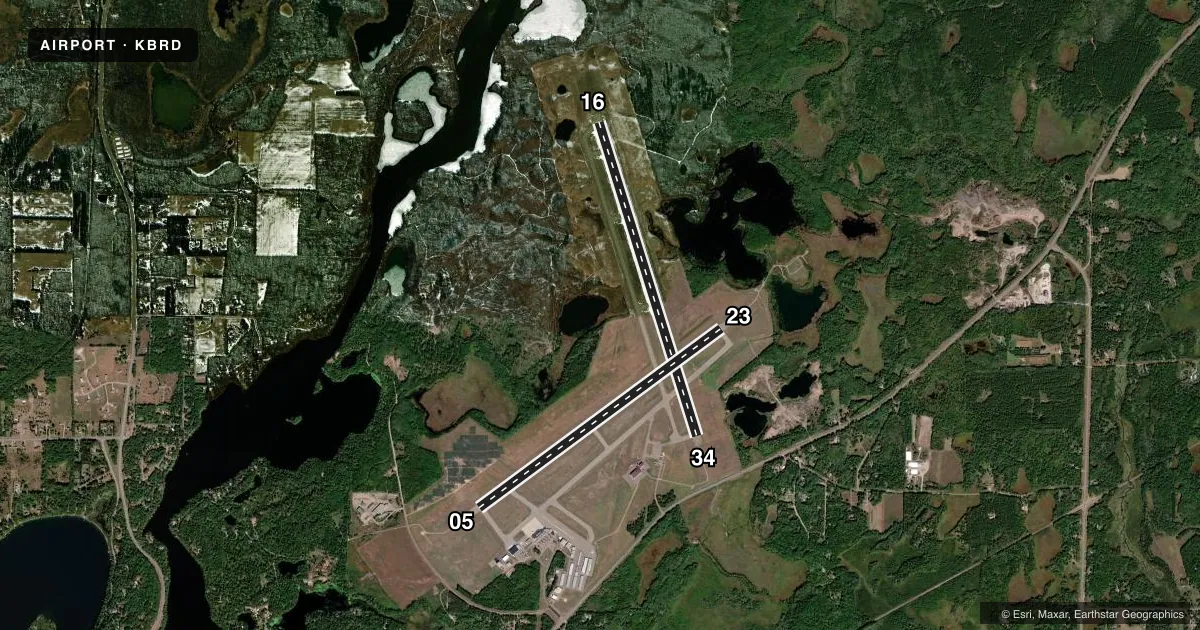
Runways & pattern
Full pagePattern entry · RWY 05
LEFT TRAFFIC| Runway | Heading (°M) | Length | Surface | Traffic |
|---|---|---|---|---|
| 16/34 | 160° / 340° | 7,100 ft | CONC | Standard L |
| 05/23Favored | 51° / 231° | 6,512 ft | CONC | Standard L |
Runway end performance
| End | TORA | TODA | ASDA | LDA | VGSI | Approach lights | Obstruction |
|---|---|---|---|---|---|---|---|
| 16 | — | — | — | — | PAPI 4-box left(3°) | — | — |
| 34 | — | — | — | — | PAPI 4-box right(3°) | MALSR | — |
| 05 | — | — | — | — | VASI 4-box left(3°) | — | — |
| 23 | — | — | — | — | PAPI 4-box left(3°) | MALSR | 68', trees, 2803' from thr, 800' R of cntrln, slope 38 |
Declared distances in feet. TORA = takeoff run available, TODA = takeoff distance, ASDA = accelerate-stop, LDA = landing distance.
Airport sketch
Runways drawn to scale from FAA survey coordinates, rendered over satellite imagery. Not for navigation.
Approaches & charts
ILS · 2
Services on the field
Fuel grades, oxygen, maintenance, ramp storage and lighting — as declared to the FAA by the airport operator.
Fuel & services
- Fuel
- 100LLA
- Oxygen (bottled)
- High pressure
- Oxygen (bulk)
- High pressure
- Airframe repair
- Major
- Power plant repair
- Major
- Other services
- AVNCS,CHTR,INSTR,RNTL,SALES,SURV
Ramp & ground
- Transient storage
- Tie-down
- Hangar
- Landing fee
- No fee published
- Customs
- Not available
- Lighting schedule
- SEE RMK
- Beacon schedule
- SS-SR
- Beacon
- White / Green (civil land)(WG)
- Wind indicator
- Lighted
- Segmented circle
- Yes
Fuel & FBOs
Cheapest 100LL and Jet A on the field and nearby. Always confirm with the FBO before taxi.
Airport notes
Surface conditions, obstructions, local procedures, lighting outages and other notes published with each FAA cycle.
General notes
- DEER AND GULLS ON & INVOF ARPT.
- FOR ATNDC OTHER HRS, SEE FONE LISTING IN PILOT LOUNGE, 218-829-3398.
- PPR FOR UNSKED ACR OPNS WITH MORE THAN 30 PSGR SEATS CALL AMGR 218-825-2166 BTN 0800-1700. ACR OPNS INVOLVING ACFT WITH MORE THAN 30 PSGRS ARE NOT AUZD IN EXCESS OF 15 MINS BEFORE OR AFTER SKEDD ARR/DEP TIMES WITHOUT PRIOR COORDINATION WITH AMGR AND CFMN THAT ARFF IS AVBL PRIOR TO LNDG OR TKOF.
- FOR CD IF UNA TO CTC ON FSS FREQ, CTC MINNEAPOLIS ARTCC AT 651-463-5588.
Lighting notes
- HIRL RWY 05/23 & HIRL RWY 16/34 PRESET ON LOW INTST; TO INCR INTST & ACTVT REIL RWY 05 & 16 AND MALSR RWY 23 & 34 - CTAF.
Runway surface & condition
- 05/23PCR VALUE: 170/R/A/W/T
- 16/34PCR VALUE: 320/R/A/W/T
Approach & departure obstructions
- 34CALM WIND RWY.
- 23PAPI UNUSBL BYD 9 DEG RIGHT OF CRS.
Other notes
- MANAGERSWRIGHT@BRAINERDAIRPORT.COM.
VFR map & nearby airports
VFR sectional. Tap any ICAO chip to open that airport.
Key facts · KBRD
Answer card- ICAO
- KBRD
- Name
- BRAINERD LAKES RGNL
- Location
- BRAINERD, MINNESOTA
- Elevation
- 1,232.2 ft MSL
- Traffic pattern altitude
- 2,232.2 ft MSL (1,000 AGL)
- Control tower
- Non-towered (use CTAF)
- Total runways
- 2
- Longest runway
- 16/34 · 7,100 ft
- Published ILS approaches
- 2
- Published frequencies
- 2
- Magnetic variation
- 3°
- Current flight rules
- VFR
- Current wind
- 070° at 4 kt
- Favored runway now
- RWY 05
Brainerd Lakes Regional Airport is in Brainerd, Minnesota. Field elevation is 1,232.2 ft MSL. The airport has two concrete runways. The longest is 16/34 at 7,100 ft. Runway 05/23 is 6,512 ft. There is no control tower, so plan on CTAF and UNICOM 122.7 for local traffic and lighting control. Two ILS approaches are published. They serve runway ends 23 and 34.
Pattern altitude is not published. Use 1,000 ft AGL for light piston operations unless the current Chart Supplement says otherwise. NorthPoint Aviation is on the field. It carries 100LL and Jet A Prist. Deer and gulls are reported on and near the airport, so keep a sharp scan on departure and in the pattern. Runway 34 is listed as the calm wind runway. That is useful when winds are light or variable.
The lighting setup is worth knowing before you arrive at night. Runway lights on 05/23 and 16/34 are preset to low intensity. Use CTAF to raise intensity. That also activates runway end identifier lights on 05 and 16. It also brings up the medium intensity approach lighting system with runway alignment indicator lights on 23 and 34. For large unscheduled aircraft operations, prior permission is required. Check the current Chart Supplement for any other local procedures before flying in.