METAR & TAF KBGR
Current METAR
Observed 16:53Z
KBGR 271653Z VRB04KT 10SM CLR 27/08 A2980 RMK AO2 SLP089 T02720083
- Wind
- VAR @ 4 kt
- Visibility
- 10 SM
- Temp / Dew
- 27°C / 8°C
- Altimeter
- 29.80 inHg
- Clouds
- CLR
- Density alt
- 1,827 ft
- Ceiling
- Unlimited
- Rules
- VFR
Airport info & contacts
Manager on record, flight service, ARTCC, attendance schedule and pattern altitude — published by the FAA and refreshed every 28 days.
Location
- From city
- 3 NM W
- VFR sectional
- HALIFAX
- ARTCC
- ZBW · BOSTON
- NOTAM facility
- BGR (NOTAM-D)
Airport manager
- Name
- JOSE F SAAVEDRA
- Phone
- 207-992-4600
- Address
- BANGOR INTERNATIONAL ARPT, 287 GODFREY BLVD, BANGOR ME 04401
Flight service · Hours
- FSS BGR
- BANGOR1-800-WX-BRIEF
- Attendance
- ALL
Frequencies
Tap any row to copy the frequency to your clipboard.
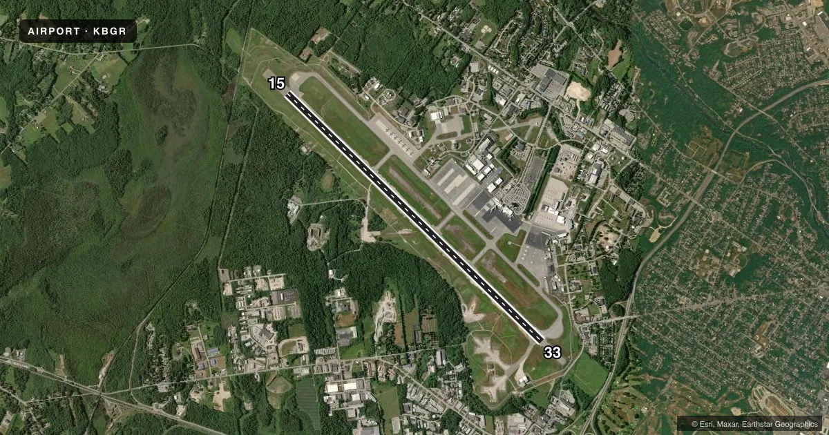
Runways & pattern
Full pagePattern entry · RWY 33
LEFT TRAFFICRunway end performance
| End | TORA | TODA | ASDA | LDA | VGSI | Approach lights | Obstruction |
|---|---|---|---|---|---|---|---|
| 15 | 11,440' | 11,440' | 11,440' | 11,440' | PAPI 4-box left(3°) | ALSF2 | — |
| 33 | 11,440' | 11,440' | 11,440' | 11,440' | PAPI 4-box left(3°) | MALSR | 76', trees, 2800' from thr, 0' R of cntrln, slope 34 |
Declared distances in feet. TORA = takeoff run available, TODA = takeoff distance, ASDA = accelerate-stop, LDA = landing distance.
Airport sketch
Runways drawn to scale from FAA survey coordinates, rendered over satellite imagery. Not for navigation.
Approaches & charts
ILS · 2
Services on the field
Fuel grades, oxygen, maintenance, ramp storage and lighting — as declared to the FAA by the airport operator.
Fuel & services
- Fuel
- 100LLA
- Oxygen (bottled)
- Low pressure
- Oxygen (bulk)
- Low pressure
- Airframe repair
- Major
- Power plant repair
- Major
- Other services
- AFRT,CARGO,CHTR,INSTR,SALES
Ramp & ground
- Transient storage
- Tie-down
- Hangar
- Landing fee
- Yes
- Customs
- Not available
- Beacon schedule
- SS-SR
- Beacon
- White / Green (civil land)(WG)
- Wind indicator
- Lighted
- Segmented circle
- No
Fuel & FBOs
Cheapest 100LL and Jet A on the field and nearby. Always confirm with the FBO before taxi.
Airport notes
Surface conditions, obstructions, local procedures, lighting outages and other notes published with each FAA cycle.
General notes
- ANG: TRANSIENT ACFT MAY BE DIVERTED TO CIVILIAN SIDE DURING NON-DUTY HRS & WEEKENDS. FEE REQUIRED; NO ANG TRANSIENT ALERT.
- TFC PAT: RWY 33 LEFT TFC, TURBO JET TFC 2000' MSL UNLESS OTHERWISE INSTR.
- MISC: RWY 15-33 GROOVED.
- ARNG: OPR 1230-2100Z++ MON-FRI EXC HOL. LTD MAINT. J8. PPR MAY-OCT SVC DSN 626-1100.
- ANG: CAUTION: BASH PHASE II PERIOD SEP-NOV, APR-MAY. EXPECT INCREASED BIRD ACTIVITY. CONTACT BASE OPS/COMMAND POST/SOF FOR CURRENT BIRDWATCH COND.
- FUEL: A++ (MIL).
- SVC MIL-FLUID: OFF-BASE CONTRACTED LOX AVBL H24-RQR 24 HR NOTICE.
- ANG: OPR 1100-1930Z++ MON-FRI, CLSD WKEND AND HOL. PPR RQRD FOR ANG RAMP. CTC AFLD MGMT DSN 698-7232, C207-404-7232 FOR PPR DURG OPR HRS. PRE-COORD ALL TRNSPN RQMNTS AND HAZ CARGO WITH PPR REQ.
- ANG: PPR VALID +/- 1 HR UNLESS PRIOR CDN. 3 HR OUT CALL, 30 MIN OUT CALL 311.0 TO CFM CSTMS/AG AND TRAN SVC. COMMAND POST C207-404-7788 H24.
Runway surface & condition
- 15/33PCR VALUE: 735/R/B/W/U
Other notes
- THIS AIRPORT HAS BEEN SURVEYED BY THE NATIONAL GEODETIC SURVEY.
- ARFF INDEX B WITH INDEX E CAPABILITIES AVBL 24/7.
VFR map & nearby airports
VFR sectional. Tap any ICAO chip to open that airport.
Key facts · KBGR
Answer card- ICAO
- KBGR
- Name
- BANGOR INTL
- Location
- BANGOR, MAINE
- Elevation
- 192.1 ft MSL
- Traffic pattern altitude
- 1,192.1 ft MSL (1,000 AGL)
- Control tower
- Towered · 24
- Total runways
- 1
- Longest runway
- 15/33 · 11,440 ft
- Published ILS approaches
- 2
- Published frequencies
- 15
- Magnetic variation
- 16°
- Current flight rules
- VFR
- Current wind
- 000° at 4 kt
- Favored runway now
- RWY 33
Bangor Intl is in Bangor, Maine. The field elevation is 192.1 ft MSL. It has one runway, 15/33, which is 11,440 ft long and grooved. The tower is open 24 hours. Two ILS approaches are published, one for each runway end. The pattern altitude is not published for the field. Use standard 1,000 ft AGL for light piston traffic unless ATC says otherwise.
Bangor Aviation Services is the on-field FBO. It carries AVGAS 100LL, Jet A and Jet A Prist. Call ahead if you need ramp or service details. The airport also supports military activity. Air National Guard operations run weekdays from 1100 to 1930 Zulu. Range operations run weekdays from 1230 to 2100 Zulu except holidays. Expect extra traffic and bird activity during the published BASH periods in spring and fall. Runway 33 uses left traffic. Turbojet traffic is at 2,000 ft MSL unless instructed otherwise.
For a first-time arrival, the big items are the long runway, the mixed civilian and military use and the need to stay sharp on coordination. Prior permission is required for some Air National Guard ramp access and transient use. Check the current FAA Chart Supplement for any current restrictions before you go. The field sits in a coastal Maine environment. Expect weather and wind changes to matter on arrival.