METAR & TAF KAVL
Current METAR
Observed 14:54Z
KAVL 271454Z 34009G15KT 10SM FEW022 FEW044 26/19 A3000 RMK AO2 SLP127 T02610194 51002
- Wind
- 340° @ 9G15 kt
- Visibility
- 10 SM
- Temp / Dew
- 26°C / 19°C
- Altimeter
- 30.00 inHg
- Clouds
- FEW
- Density alt
- 3,904 ft
- Ceiling
- Unlimited
- Rules
- VFR
Airport info & contacts
Manager on record, flight service, ARTCC, attendance schedule and pattern altitude — published by the FAA and refreshed every 28 days.
Location
- From city
- 9 NM S
- VFR sectional
- ATLANTA
- ARTCC
- ZTL · ATLANTA
- NOTAM facility
- AVL (NOTAM-D)
Airport manager
- Name
- LEW S. BLEIWEIS, A.A.E.
- Phone
- 828-684-4577
- Address
- 61 TERMINAL DRIVE; SUITE 1, FLETCHER NC 28731-9442
Flight service · Hours
- FSS RDU
- RALEIGH1-800-WX-BRIEF
- Attendance
- ALL
Frequencies
Tap any row to copy the frequency to your clipboard.
Runways & pattern
Full pagePattern entry · RWY 35
RIGHT TRAFFICRunway end performance
| End | TORA | TODA | ASDA | LDA | VGSI | Approach lights | Obstruction |
|---|---|---|---|---|---|---|---|
| 17 | 8,002' | 8,002' | 8,002' | 8,002' | PAPI 4-box right(3°) | MALSR | — |
| 35 | 8,002' | 8,002' | 8,002' | 8,002' | PAPI 4-box left(3°) | MALSR | — |
Declared distances in feet. TORA = takeoff run available, TODA = takeoff distance, ASDA = accelerate-stop, LDA = landing distance.
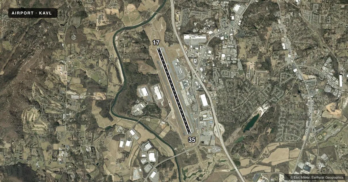
Airport sketch
Runways drawn to scale from FAA survey coordinates, rendered over satellite imagery. Not for navigation.
Approaches & charts
ILS · 2
Services on the field
Fuel grades, oxygen, maintenance, ramp storage and lighting — as declared to the FAA by the airport operator.
Fuel & services
- Fuel
- 100LLA
- Oxygen (bottled)
- High pressure
- Oxygen (bulk)
- Not available
- Airframe repair
- Minor
- Power plant repair
- Minor
- Other services
- AFRT,CARGO,CHTR,INSTR,RNTL
Ramp & ground
- Transient storage
- Tie-down
- Hangar
- Landing fee
- No fee published
- Customs
- Not available
- Lighting schedule
- SEE RMK
- Beacon schedule
- SS-SR
- Beacon
- White / Green (civil land)(WG)
- Wind indicator
- Lighted
- Segmented circle
- Yes
Fuel & FBOs
Cheapest 100LL and Jet A on the field and nearby. Always confirm with the FBO before taxi.
Airport notes
Surface conditions, obstructions, local procedures, lighting outages and other notes published with each FAA cycle.
General notes
- FOR THE ASHEVILLE REGIONAL AIRPORT AIRCRAFT DIVERSIONS EMERGENCY CONTINGENCY PLAN AND FACILITY CONSTRAINTS CTC ARPT ADMIN AT 828-684-2226.
- FLOCKS OF MIGRATORY BIRDS ON AND INVOF ARPT.
- WHEN ATCT CLSD, FOR CD CTC ATLANTA ARTCC AT 770-210-7692.
Lighting notes
- WHEN TWR CLSD, ACTVT MALSR RWY 17 & 35; PAPI RWYS 17 & 35; HIRLS RWY 17/35 - CTAF.
Runway surface & condition
- 17/35PCR VALUE: 440/F/A/X/T
Approach & departure obstructions
- 35RWY 35 RIGHT TRAFFIC WHEN ATCT CLSD.
Other notes
- PPR FOR UNSKED ACR OPNS WITH MORE THAN 30 PSGR SEATS 0400-1200Z; CALL APRT COMM 828-684-4577.
- MANAGER(828) 684-4577 OR EMERG CTC - (828) 209-5100.
VFR map & nearby airports
VFR sectional. Tap any ICAO chip to open that airport.
Key facts · KAVL
Answer card- ICAO
- KAVL
- Name
- ASHEVILLE RGNL
- Location
- ASHEVILLE, NORTH CAROLINA
- Elevation
- 2,163.9 ft MSL
- Traffic pattern altitude
- 3,163.9 ft MSL (1,000 AGL)
- Control tower
- Towered · 0630-2300
- Total runways
- 1
- Longest runway
- 17/35 · 8,002 ft
- Published ILS approaches
- 2
- Published frequencies
- 16
- Magnetic variation
- 7°
- Current flight rules
- VFR
- Current wind
- 340° at 9 kt
- Favored runway now
- RWY 35
Asheville Regional Airport sits in Asheville, North Carolina. The field elevation is 2,163.9 ft MSL. It has one runway, 17/35, which is 8,002 ft long. The airport is towered from 0630 to 2300. Two ILS approaches are published, one for each runway end. Pattern altitude is not published in the facts. Use the standard 1,000 ft AGL for light piston traffic unless ATC or the current Chart Supplement says otherwise.
Signature Aviation is on the field. It carries 100LL and Jet A. The airport sits in a mountain region so expect terrain to matter on arrival and departure. Flocks of migratory birds are also noted in the published remarks. That is worth keeping in mind on the approach and in the pattern. When the tower is closed, runway 35 uses right traffic. The published remarks also say the approach lights, PAPI and high intensity runway lights for 17/35 can be activated on CTAF when the tower is closed. Check the current FAA Chart Supplement for any noise or curfew restrictions before flying into the field. If you need current operational details, call the airport operator or the FBO directly by phone.