METAR & TAF S75
S75 does not publish a METAR.
Showing the nearest reporting station: KONO (ONTARIO MUNI) · 6.5 NM away. Conditions at S75 may differ.
METAR · KONO
Observed 01:53Z
KONO 120153Z AUTO 00000KT 10SM CLR 24/M04 A3001 RMK AO2 SLP159 T02441044
- Wind
- 000° @ 0 kt
- Visibility
- 10 SM
- Temp / Dew
- 24°C / -4°C
- Altimeter
- 30.01 inHg
- Clouds
- CLR
- Density alt
- 3,734 ft
- Ceiling
- Unlimited
- Rules
- VFR
Airport info & contacts
Manager on record, flight service, ARTCC, attendance schedule and pattern altitude — published by the FAA and refreshed every 28 days.
Location
- From city
- 2 NM NE
- VFR sectional
- SALT LAKE CITY
- ARTCC
- ZLC · SALT LAKE CITY
- NOTAM facility
- BOI (NOTAM-D)
Airport manager
- Name
- FRAZIER PETERSON
- Phone
- 208-440-7948
- Address
- 700 CENTER AVE, PAYETTE ID 83661
Flight service · Hours
- FSS BOI
- BOISE1-800-WX-BRIEF
- Attendance
- Unattended
Frequencies
Tap any row to copy the frequency to your clipboard.
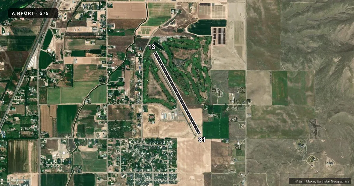
Runways & pattern
Full pagePattern entry · RWY 13
LEFT TRAFFICRunway end performance
| End | TORA | TODA | ASDA | LDA | VGSI | Approach lights | Obstruction |
|---|---|---|---|---|---|---|---|
| 13 | — | — | — | — | — | — | 24', tree, 380' from thr, 130' R of cntrln, slope 7 |
| 31 | — | — | — | — | — | — | 4', fence, 200' from thr, 50' R of cntrln, slope 0 |
Declared distances in feet. TORA = takeoff run available, TODA = takeoff distance, ASDA = accelerate-stop, LDA = landing distance.
Airport sketch
Runways drawn to scale from FAA survey coordinates, rendered over satellite imagery. Not for navigation.
Approaches & charts
Services on the field
Fuel grades, oxygen, maintenance, ramp storage and lighting — as declared to the FAA by the airport operator.
Fuel & services
- Fuel
- 100LLMOGAS
- Oxygen (bottled)
- Not available
- Oxygen (bulk)
- Not available
- Airframe repair
- Minor
- Power plant repair
- Minor
Ramp & ground
- Transient storage
- Tie-down
- Hangar
- Landing fee
- No fee published
- Customs
- Not available
- Lighting schedule
- SEE RMK
- Beacon schedule
- SS-SR
- Beacon
- White / Green (civil land)(WG)
- Wind indicator
- Lighted
- Segmented circle
- Yes
Fuel & FBOs
Cheapest 100LL and Jet A on the field and nearby. Always confirm with the FBO before taxi.
Airport notes
Surface conditions, obstructions, local procedures, lighting outages and other notes published with each FAA cycle.
General notes
- ARPT CLSD TO ACFT OVER 10000 LBS GWT.
- 2885' MSL (405' AGL) MKD & LGTD STEEL TWR LCTD 2.2 MILES S OF ARPT.
- GOLFERS ADJACENT TO TWY EDGES & RY 13 THR.
- RY 13 DSPLD THLD NOT LIGHTED.
- FOR CD CTC SALT LAKE ARTCC AT 801-320-2568.
Lighting notes
- ACTVT LIRL RWY 13/31-CTAF (3 CLICKS).
Fuel notes
- 100LLFUEL 24 HR CREDIT CARD SVC AVBL. MO GAS AVBL
Approach & departure obstructions
- 13+35' TREES 190' FM EOR, 65' L; +6' BLDG, 75' EOR, 50'L.
- 13RWY 13 APCH SLP 42:1 TO DTHR.
Other notes
- ESTABD PRIOR TO 15 MAY 1959.
VFR map & nearby airports
VFR sectional. Tap any ICAO chip to open that airport.
Key facts · S75
Answer card- ICAO
- S75
- Name
- PAYETTE MUNI
- Location
- PAYETTE, IDAHO
- Elevation
- 2,230 ft MSL
- Traffic pattern altitude
- 3,230 ft MSL (1,000 AGL)
- Control tower
- Non-towered (use CTAF)
- Total runways
- 1
- Longest runway
- 13/31 · 3,534 ft
- Published ILS approaches
- 0
- Published frequencies
- 1
- Magnetic variation
- 17°
- Current flight rules
- VFR
- Current wind
- 000° at 0 kt
- Favored runway now
- –
Payette Muni is in Payette, Idaho. The field elevation is 2,230 ft MSL. It has one runway. Runway 13/31 is 3,534 ft long and asphalt. There is no control tower, so use CTAF 122.9 for local traffic calls. No ILS approaches are published here, so plan with current VFR or non-ILS IFR options and check the current FAA Chart Supplement before you go.
The published pattern altitude is not listed. Use the standard 1,000 ft AGL pattern for light piston aircraft unless the current Chart Supplement says otherwise. On the field, Payette Municipal Airport carries 100LL and MOGAS. Fuel is available 24 hours with credit card service. Runway 13 has a displaced threshold that is not lighted. Low intensity runway lights on 13/31 are activated by three clicks on the CTAF.
There are a few items a first-time pilot should know. The airport is closed to aircraft over 10,000 pounds gross weight. A marked and lighted steel tower sits 2.2 miles south of the airport. Trees and a small building are close to the runway 13 end, so pay attention to the departure and approach path there. Golfers are adjacent to the taxiway edges and the runway 13 threshold. If you need clearance delivery, contact Salt Lake ARTCC at 801-320-2568. This is a non-towered field, so keep your radio work tight and expect local traffic on CTAF.