METAR & TAF KTYL
Current METAR
Observed 09:15Z
KTYL 120915Z AUTO 13004KT 10SM CLR 16/M05 A3013 RMK AO2
- Wind
- 130° @ 4 kt
- Visibility
- 10 SM
- Temp / Dew
- 16°C / -5°C
- Altimeter
- 30.13 inHg
- Clouds
- CLR
- Density alt
- 7,080 ft
- Ceiling
- Unlimited
- Rules
- VFR
Airport info & contacts
Manager on record, flight service, ARTCC, attendance schedule and pattern altitude — published by the FAA and refreshed every 28 days.
Location
- From city
- 2 NM SW
- VFR sectional
- PHOENIX
- ARTCC
- ZAB · ALBUQUERQUE
- NOTAM facility
- PRC (NOTAM-D)
Airport manager
- Name
- RAY WEBBER
- Phone
- 928-606-9779
- Address
- BOX 158, TAYLOR AZ 85939
Flight service · Hours
- FSS PRC
- PRESCOTT1-800-WX-BRIEF
- Attendance
- MON-FRI · 0730-1700
Frequencies
Tap any row to copy the frequency to your clipboard.
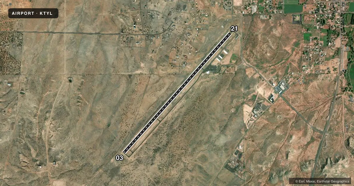
Runways & pattern
Full pagePattern entry · RWY 03
LEFT TRAFFICRunway end performance
| End | TORA | TODA | ASDA | LDA | VGSI | Approach lights | Obstruction |
|---|---|---|---|---|---|---|---|
| 03 | — | — | — | — | PAPI 2-box left(4°) | — | — |
| 21 | — | — | — | — | PAPI 2-box left(3°) | — | — |
Declared distances in feet. TORA = takeoff run available, TODA = takeoff distance, ASDA = accelerate-stop, LDA = landing distance.
Airport sketch
Runways drawn to scale from FAA survey coordinates, rendered over satellite imagery. Not for navigation.
Approaches & charts
Services on the field
Fuel grades, oxygen, maintenance, ramp storage and lighting — as declared to the FAA by the airport operator.
Fuel & services
- Fuel
- 100LL
- Airframe repair
- Major
- Power plant repair
- Major
- Other services
- INSTR,RNTL
Ramp & ground
- Transient storage
- Tie-down
- Landing fee
- No fee published
- Customs
- Not available
- Lighting schedule
- SEE RMK
- Beacon schedule
- SS-SR
- Beacon
- White / Green (civil land)(WG)
- Wind indicator
- Lighted
- Segmented circle
- Yes
Fuel & FBOs
Cheapest 100LL and Jet A on the field and nearby. Always confirm with the FBO before taxi.
Airport notes
Surface conditions, obstructions, local procedures, lighting outages and other notes published with each FAA cycle.
General notes
- WILDLIFE ON OR INVOF ARPT.
- NMRS RWY HOLD & EXIT SIGNS OTS INDEF.
- FOR CD CTC ALBUQUERQUE ARTCC AT 505-856-4861.
Lighting notes
- ACTVT REIL RWY 03 & 21; PAPI RWY 03 & 21; MIRL RWY 03/21 - CTAF.
Fuel notes
- 100LLSELF SVC H24 WITH CREDIT CARD.
Runway surface & condition
- 03/214-9 FT TREES & BRUSH IN PRIM SFC NW SIDE OF RWY 100-250 FT FM CNTRLN.
Other notes
- MANAGERGUS LUNDBERG 928-536-7366.
VFR map & nearby airports
VFR sectional. Tap any ICAO chip to open that airport.
Key facts · KTYL
Answer card- ICAO
- KTYL
- Name
- TAYLOR
- Location
- TAYLOR, ARIZONA
- Elevation
- 5,823.1 ft MSL
- Traffic pattern altitude
- 6,823.1 ft MSL (1,000 AGL)
- Control tower
- Non-towered (use CTAF)
- Total runways
- 1
- Longest runway
- 03/21 · 7,001 ft
- Published ILS approaches
- 0
- Published frequencies
- 2
- Magnetic variation
- 9°
- Current flight rules
- VFR
- Current wind
- 130° at 4 kt
- Favored runway now
- RWY 03
Taylor Airport sits in Taylor, Arizona. The field elevation is 5,823.1 ft MSL. It has one runway, 03/21, which is 7,001 ft long. There is no control tower. CTAF and UNICOM are both 122.7. No ILS approaches are published.
Pattern altitude is not published. Use 1,000 ft AGL for light piston traffic unless the current Chart Supplement says otherwise. That puts the standard pattern at about 6,823 ft MSL. The airport is in a high-elevation part of Arizona, so performance planning matters. Expect density altitude to be a real factor on warm days.
Ray's Aircraft Services is on the field. It carries 100LL. Self-serve 100LL is available 24 hours with a credit card. The airport manager is Gus Lundberg at 928-536-7366. Wildlife is present on or near the airport, so watch for movement on the runway and taxi areas. Runway end identifier lights are available on 03 and 21. PAPI is available on both ends. Medium intensity runway lights on 03/21 are controlled by CTAF. Runway hold and exit signs are out of service indefinitely. For clearance delivery, contact Albuquerque ARTCC at 505-856-4861 before departure if you need help getting started.