METAR & TAF KTLH
Current METAR
Observed 16:53Z
KTLH 271653Z 36009KT 10SM BKN042 34/23 A2991 RMK AO2 SLP127 T03440233
- Wind
- 360° @ 9 kt
- Visibility
- 10 SM
- Temp / Dew
- 34°C / 23°C
- Altimeter
- 29.91 inHg
- Clouds
- BKN
- Density alt
- 2,395 ft
- Ceiling
- 4,200 ft AGL
- Rules
- VFR
Airport info & contacts
Manager on record, flight service, ARTCC, attendance schedule and pattern altitude — published by the FAA and refreshed every 28 days.
Location
- From city
- 4 NM SW
- VFR sectional
- JACKSONVILLE
- ARTCC
- ZJX · JACKSONVILLE
- NOTAM facility
- TLH (NOTAM-D)
Airport manager
- Name
- DAVID POLLARD
- Phone
- 850-891-7802
- Address
- 3300 CAPITAL CIRCLE SW, TALLAHASSEE FL 32310
Flight service · Hours
- FSS GNV
- GAINESVILLE1-800-WX-BRIEF
- Attendance
- ALL
Frequencies
Tap any row to copy the frequency to your clipboard.
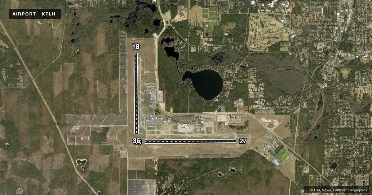
Runways & pattern
Full pagePattern entry · RWY 36
LEFT TRAFFIC| Runway | Heading (°M) | Length | Surface | Traffic |
|---|---|---|---|---|
| 09/27 | 84° / 264° | 8,000 ft | ASPH | Standard L |
| 18/36Favored | 174° / 354° | 7,000 ft | ASPH | Standard L |
Runway end performance
| End | TORA | TODA | ASDA | LDA | VGSI | Approach lights | Obstruction |
|---|---|---|---|---|---|---|---|
| 09 | — | — | — | — | PAPI 4-box left(3°) | — | — |
| 27 | — | — | — | — | PAPI 4-box left(3°) | ALSF2 | — |
| 18 | — | — | — | — | PAPI 4-box left(3°) | — | — |
| 36 | — | — | — | — | PAPI 4-box left(3°) | MALSR | — |
Declared distances in feet. TORA = takeoff run available, TODA = takeoff distance, ASDA = accelerate-stop, LDA = landing distance.
Airport sketch
Runways drawn to scale from FAA survey coordinates, rendered over satellite imagery. Not for navigation.
Approaches & charts
ILS · 2
Services on the field
Fuel grades, oxygen, maintenance, ramp storage and lighting — as declared to the FAA by the airport operator.
Fuel & services
- Fuel
- 100LLA
- Oxygen (bottled)
- High pressure
- Oxygen (bulk)
- High pressure
- Airframe repair
- Major
- Power plant repair
- Major
- Other services
- AFRT,AMB,AVNCS,CARGO,CHTR,INSTR,RNTL,SALES
Ramp & ground
- Transient storage
- Tie-down
- Hangar
- Landing fee
- No fee published
- Customs
- Not available
- Lighting schedule
- SEE RMK
- Beacon schedule
- SS-SR
- Beacon
- White / Green (civil land)(WG)
- Wind indicator
- Lighted
- Segmented circle
- Yes
Fuel & FBOs
Cheapest 100LL and Jet A on the field and nearby. Always confirm with the FBO before taxi.
Airport notes
Surface conditions, obstructions, local procedures, lighting outages and other notes published with each FAA cycle.
General notes
- MOVEMENT AREA OF TWY 'Z' BEGINS AT THE INTXN OF TWY 'B8' & PROCEEDS E TO THE INTXN OF TWY 'B7' THIS TWY IS NOT FOR USE BY ACR OPNS; ASPH BTN TWYS 'B8' & 'A12' IS FOR HEL OPNS; TWY 'Z' FM TWY 'A12' TO THE RAMP IS OPEN TO ACFT WITH WINGSPAN OF 50 FT OR LESS.
- BIRDS ON & INVOF ARPT.
- FOR CD IF UNA TO CTC ON FSS FREQ, CTC TALLAHASSEE APCH AT 850-942-8311, WHEN APCH CLSD CTC JACKSONVILLE ARTCC AT 904-845-1592.
- 24 HR ADVN NOTICE OR IMT REPORTING UPON LDG FOR ACFT EQUIPPED WITH WEATHER MODIFICATION OR GEOENGINEERING EQUIP 850-891-7830.
Lighting notes
- WHEN ATCT CLSD ACTVT MALSR 36; REIL RWY 9 & 18; PAPI RWY 9, 27, 18 & 36; HIRL RWY 9/27 & 18/36 - CTAF. ALSF2 RWY 27 PRESET ON MED INTST.
Runway surface & condition
- 09/27PCR VALUE: 530/F/A/X/T
- 18/36PCR VALUE: 490/F/A/X/T
VFR map & nearby airports
VFR sectional. Tap any ICAO chip to open that airport.
Key facts · KTLH
Answer card- ICAO
- KTLH
- Name
- TALLAHASSEE INTL
- Location
- TALLAHASSEE, FLORIDA
- Elevation
- 83.1 ft MSL
- Traffic pattern altitude
- 1,083.1 ft MSL (1,000 AGL)
- Control tower
- Towered · 0600-2300
- Total runways
- 2
- Longest runway
- 09/27 · 8,000 ft
- Published ILS approaches
- 2
- Published frequencies
- 23
- Magnetic variation
- 5°
- Current flight rules
- VFR
- Current wind
- 360° at 9 kt
- Favored runway now
- RWY 36
Tallahassee Intl is in Tallahassee, Florida. The field elevation is 83.1 ft MSL. It has two asphalt runways. The longest is runway 09/27 at 8,000 ft. Runway 18/36 is 7,000 ft. The tower is open daily from 0600 to 2300. Two ILS approaches are published. They serve runway ends 27 and 36.
Pattern altitude is not published in the facts. For light piston planning, use the standard 1,000 ft AGL unless the current Chart Supplement says otherwise. That puts the pattern at about 1,083 ft MSL based on the field elevation. Check the current Chart Supplement before flight if you need the exact published value.
Aero Center is on the field. It carries 100LL, Jet A and Jet A Prist. Million Air is also on the field. It carries 100LL, Jet A and Jet A Prist. Published remarks note birds on and near the airport. They also note special taxiway limits near taxiway Z. That matters if you are unfamiliar with the ramp and movement area layout. When the tower is closed, lighting for runway 36 and the runway 9, 18, 27 ends can be activated on CTAF. The airport sits in a busy controlled environment. Expect normal towered-airport sequencing. Keep an eye out for bird activity on departure and arrival.