METAR & TAF 2J0
2J0 does not publish a METAR.
Showing the nearest reporting station: KTLH (TALLAHASSEE INTL) · 24.6 NM away. Conditions at 2J0 may differ.
METAR · KTLH
Observed 11:53Z
KTLH 271153Z 29005KT 10SM SCT038 27/26 A2991 RMK AO2 SLP128 60003 70003 T02670256 10272 20256 53004
- Wind
- 290° @ 5 kt
- Visibility
- 10 SM
- Temp / Dew
- 27°C / 26°C
- Altimeter
- 29.91 inHg
- Clouds
- SCT
- Density alt
- 1,466 ft
- Ceiling
- Unlimited
- Rules
- VFR
Airport info & contacts
Manager on record, flight service, ARTCC, attendance schedule and pattern altitude — published by the FAA and refreshed every 28 days.
Location
- From city
- 3 NM S
- VFR sectional
- JACKSONVILLE
- ARTCC
- ZJX · JACKSONVILLE
- NOTAM facility
- GNV (NOTAM-D)
Airport manager
- Name
- STEVEN FULTS
- Phone
- 850-321-0373
- Address
- 35 MONOCOUPE CIRCLE, PANACEA FL 32346
Flight service · Hours
- FSS GNV
- GAINESVILLE1-800-WX-BRIEF
- Attendance
- Unattended
Frequencies
Tap any row to copy the frequency to your clipboard.
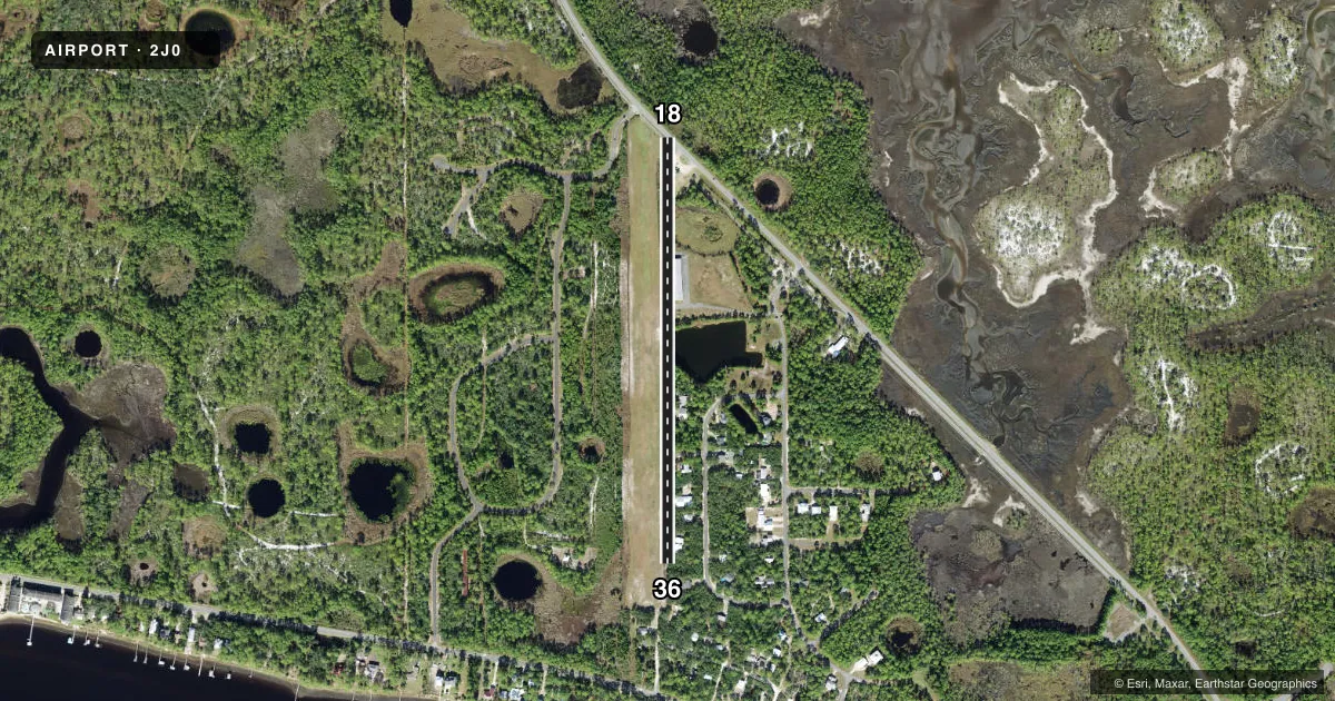
Runways & pattern
Full pagePattern entry · RWY 36
LEFT TRAFFICRunway end performance
| End | TORA | TODA | ASDA | LDA | VGSI | Approach lights | Obstruction |
|---|---|---|---|---|---|---|---|
| 18 | — | — | — | — | — | — | 15', road, 102' from thr, 125' R of cntrln, slope 6 |
| 36 | — | — | — | — | — | — | 35', trees, 250' from thr, 20' R of cntrln, slope 7 |
Declared distances in feet. TORA = takeoff run available, TODA = takeoff distance, ASDA = accelerate-stop, LDA = landing distance.
Airport sketch
Runways drawn to scale from FAA survey coordinates, rendered over satellite imagery. Not for navigation.
Approaches & charts
Services on the field
Fuel grades, oxygen, maintenance, ramp storage and lighting — as declared to the FAA by the airport operator.
Fuel & services
- Fuel
- Not available
- Oxygen (bottled)
- Not available
- Oxygen (bulk)
- Not available
- Airframe repair
- Not available
- Power plant repair
- Not available
- Other services
- AMB
Ramp & ground
- Transient storage
- Tie-down
- Landing fee
- No fee published
- Lighting schedule
- SEE RMK
- Wind indicator
- Yes
- Segmented circle
- No
Fuel & FBOs
Cheapest 100LL and Jet A on the field and nearby. Always confirm with the FBO before taxi.
Airport notes
Surface conditions, obstructions, local procedures, lighting outages and other notes published with each FAA cycle.
General notes
- AER 36 HAS 10-25 FT TREES AND 5 FT FENCE 90 FT EAST OF CNTRLN.
- TREES, BLDGS, WINDSOCK POLES, LIGHTNING DETECTION SYSTEM, BERMS AND UTILITY POLES 75-125 FT EAST OF RY 18/36.
- 50 FT TREES 100-125 FT WEST OF RWY 18/36 FULL LEN.
- FOR CD CTC TALLAHASSEE APCH AT 850-942-8311, WHEN APCH CLSD CTC JACKSONVILLE ARTCC AT 904-845-1592.
- 24 HR ADVN NOTICE OR IMT REPORTING UPON LDG FOR ACFT EQUIPPED WITH WEATHER MODIFICATION OR GEOENGINEERING EQUIP CTC ARPT OPS 850-321-0373.
Lighting notes
- LGTS OTS
Approach & departure obstructions
- 18RWY 18/36 LEN AND WID AND DSPLCD THLDS MKD WITH W PVC PIPES.
- 18RWY 36 APCH SLP 20:1 TO MKD DTHR.
Other notes
- VFR ONLY.
- 1GROUND ACCESS BY PRIOR REQUEST, 850-321-0373.
- MANAGERAIRPORT PHYSICAL ADDRESS: 30 BAY DR, PANACEA, FL 32346
- OWNERCONTACT PERSON: DAVID EDWARDS
- MANAGERALT PHONE 850-321-0373
- 18/36RY 18/36 SOFT TURF.
VFR map & nearby airports
VFR sectional. Tap any ICAO chip to open that airport.
Key facts · 2J0
Answer card- ICAO
- 2J0
- Name
- WAKULLA COUNTY
- Location
- PANACEA, FLORIDA
- Elevation
- 11 ft MSL
- Traffic pattern altitude
- 1,011 ft MSL (1,000 AGL)
- Control tower
- Non-towered (use CTAF)
- Total runways
- 1
- Longest runway
- 18/36 · 2,590 ft
- Published ILS approaches
- 0
- Published frequencies
- 1
- Magnetic variation
- 1°
- Current flight rules
- VFR
- Current wind
- 290° at 5 kt
- Favored runway now
- RWY 36
Wakulla County Airport sits in Panacea, Florida. The field elevation is 11 ft MSL. It has one runway. The longest is 18/36 at 2,590 ft. This is a non-towered field. CTAF is 122.9. No ILS approaches are published here. The pattern altitude is not published, so use the current FAA Chart Supplement for the published traffic pattern before you go.
The runway is soft turf. The published remarks matter here. Trees sit near both sides of the runway environment. Runway 36 also has trees and a fence near the approach end. The runway markings are done with white PVC pipes. Lights are out of service. That makes this a day VFR field only in practical terms. The airport also notes VFR only in the remarks.
No on-field FBOs are listed. Contact the airport operator directly before arrival if you need current services or ground access. Ground access is by prior request. For clearance delivery, the published contact is Tallahassee Approach when it is open. When approach is closed, use Jacksonville ARTCC. Pilots with weather modification or geoengineering equipment need to give advance notice or report immediately after landing. For a first-time arrival, plan a careful look at the turf condition, the tree environment and the lack of lighting before you go.