METAR & TAF F47
F47 does not publish a METAR.
Showing the nearest reporting station: KAAF (APALACHICOLA RGNL-CLEVE RANDOLPH FLD) · 7.7 NM away. Conditions at F47 may differ.
METAR · KAAF
Observed 14:53Z
KAAF 271453Z AUTO 36009KT 10SM CLR 32/25 A2992 RMK AO1 SLP132 60001 T03220250 53001 $
- Wind
- 360° @ 9 kt
- Visibility
- 10 SM
- Temp / Dew
- 32°C / 25°C
- Altimeter
- 29.92 inHg
- Clouds
- CLR
- Density alt
- 2,044 ft
- Ceiling
- Unlimited
- Rules
- VFR
Airport info & contacts
Manager on record, flight service, ARTCC, attendance schedule and pattern altitude — published by the FAA and refreshed every 28 days.
Location
- From city
- 8 NM SE
- VFR sectional
- NEW ORLEANS
- ARTCC
- ZJX · JACKSONVILLE
- NOTAM facility
- GNV (NOTAM-D)
Airport manager
- Name
- BOB SHIVER
- Phone
- 850-927-2312
- Address
- 1712 MAGNOLIA ROAD, ST GEORGE ISLAND FL 32328
Flight service · Hours
- FSS GNV
- GAINESVILLE1-800-WX-BRIEF
- Attendance
- Unattended
Frequencies
Tap any row to copy the frequency to your clipboard.
Runways & pattern
Full pagePattern entry · RWY 32
LEFT TRAFFICRunway end performance
| End | TORA | TODA | ASDA | LDA | VGSI | Approach lights | Obstruction |
|---|---|---|---|---|---|---|---|
| 32 | — | — | — | — | — | — | 12', brush, 240' from thr, 90' R of cntrln, slope 3 |
Declared distances in feet. TORA = takeoff run available, TODA = takeoff distance, ASDA = accelerate-stop, LDA = landing distance.
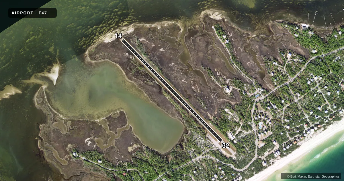
Airport sketch
Runways drawn to scale from FAA survey coordinates, rendered over satellite imagery. Not for navigation.
Approaches & charts
Services on the field
Fuel grades, oxygen, maintenance, ramp storage and lighting — as declared to the FAA by the airport operator.
Fuel & services
- Fuel
- Not available
Ramp & ground
- Transient storage
- Not published
- Landing fee
- Yes
- Wind indicator
- Yes
- Segmented circle
- No
Fuel & FBOs
Cheapest 100LL and Jet A on the field and nearby. Always confirm with the FBO before taxi.
Airport notes
Surface conditions, obstructions, local procedures, lighting outages and other notes published with each FAA cycle.
General notes
- GROUND ACCESS BY PERMISSION ONLY.
- LARGE BIRDS ON AND INVOF RY.
- TREES, BRUSH AND BERM, 95-124 FT EAST OF RY CNTRLN RY 32.
- 5 FT BERM, FIRST 1250 FT, 100 FT WEST OF CNTRLN RY 14.
- RY AND RAMP ARE OPEN FOR PUB USE. ALL OTHER SURROUNDING GROUNDS ARE PVT. ACCESS TO ALL AREAS EXCEPT THE RY AND RAMP RQR AN OWNER WI THE PROPERTY ASSOCIATION.
- FOR CD CTC TYNDALL APCH AT 850-283-2900 OR 850-283-3353, WHEN APCH CLSD CTC JACKSONVILLE ARTCC AT 904-845-1592.
Approach & departure obstructions
- 14BRUSH 90 FT RIGHT OF CNTRLN, 290 FT AFT THE APCH END OF RWY 14.
- 32TREES 120 FT RIGHT OF CNTRLN, 200 FT BFR THE APCH END OF RWY 32.
Other notes
- VFR USE ONLY.
- MANAGERALT CTC: PHILIP SQUARE - PSQUARE@SGPOA.COM
VFR map & nearby airports
VFR sectional. Tap any ICAO chip to open that airport.
Key facts · F47
Answer card- ICAO
- F47
- Name
- ST GEORGE ISLAND
- Location
- APALACHICOLA, FLORIDA
- Elevation
- 3 ft MSL
- Traffic pattern altitude
- 1,003 ft MSL (1,000 AGL)
- Control tower
- Non-towered (use CTAF)
- Total runways
- 1
- Longest runway
- 14/32 · 3,339 ft
- Published ILS approaches
- 0
- Published frequencies
- 1
- Magnetic variation
- 1°
- Current flight rules
- VFR
- Current wind
- 360° at 9 kt
- Favored runway now
- RWY 32
St George Island Airport (F47) sits in Apalachicola, Florida. Field elevation is 3 ft MSL. The airport has one runway. Runway 14/32 is 3,339 ft long with an asphalt surface. There is no control tower. CTAF is 122.9. No ILS approaches are published here.
Pattern altitude is not published. Use 1,000 ft AGL for light piston operations unless the current Chart Supplement says otherwise. That puts the pattern at 1,003 ft MSL based on the field elevation. This is a VFR-only field. Check the current Chart Supplement for any local restrictions before you go.
The runway environment deserves a close look. Brush sits near the approach end of runway 14. Trees, brush and a berm are reported near runway 32. A 5-foot berm also runs along the west side of runway 14 for the first 1,250 ft. Large birds are reported on and near the runway. Ground access is by permission only. The runway and ramp are open for public use. The surrounding property is private, so plan your arrival and ground movement carefully. There are no on-field FBOs listed. Contact the airport operator directly or call on CTAF for current service details before you launch.