METAR & TAF KAAF
Current METAR
Observed 16:53Z
KAAF 271653Z AUTO 01008KT 10SM FEW041 34/25 A2991 RMK AO1 SLP129 T03440250 $
- Wind
- 010° @ 8 kt
- Visibility
- 10 SM
- Temp / Dew
- 34°C / 25°C
- Altimeter
- 29.91 inHg
- Clouds
- FEW
- Density alt
- 2,317 ft
- Ceiling
- Unlimited
- Rules
- VFR
Airport info & contacts
Manager on record, flight service, ARTCC, attendance schedule and pattern altitude — published by the FAA and refreshed every 28 days.
Location
- From city
- 2 NM W
- VFR sectional
- NEW ORLEANS
- ARTCC
- ZJX · JACKSONVILLE
- NOTAM facility
- AAF (NOTAM-D)
Airport manager
- Name
- STEVE KIRSCHENBAUM
- Phone
- 850-290-8282
- Address
- 8 AIRPORT ROAD, APALACHICOLA FL 32320-2317
Flight service · Hours
- FSS GNV
- GAINESVILLE1-800-WX-BRIEF
- Attendance
- 0800-1900
Frequencies
Tap any row to copy the frequency to your clipboard.
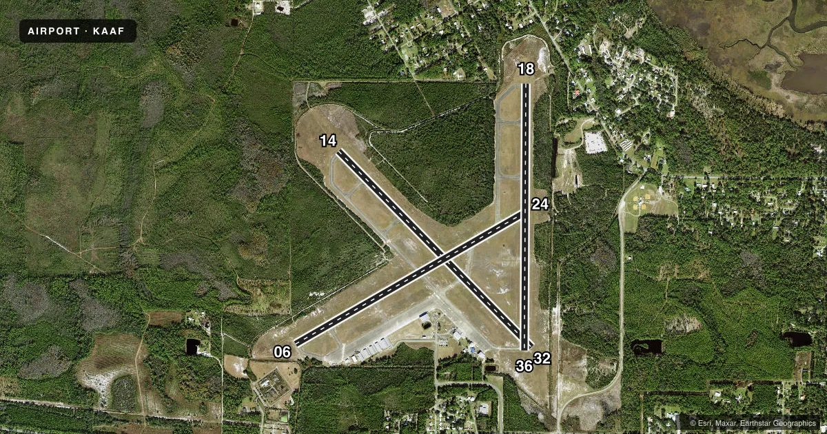
Runways & pattern
Full pagePattern entry · RWY 36
LEFT TRAFFIC| Runway | Heading (°M) | Length | Surface | Traffic |
|---|---|---|---|---|
| 14/32 | 132° / 312° | 5,425 ft | CONC | Standard L |
| 06/24 | 57° / 237° | 5,271 ft | CONC | Standard L |
| 18/36Favored | 177° / 357° | 5,251 ft | CONC | Standard L |
Runway end performance
| End | TORA | TODA | ASDA | LDA | VGSI | Approach lights | Obstruction |
|---|---|---|---|---|---|---|---|
| 14 | — | — | — | — | PAPI 2-box left(3°) | — | 23', trees, 975' from thr, 20' R of cntrln, slope 34 |
| 32 | — | — | — | — | PAPI 2-box left(3°) | — | 11', brush, 395' from thr, 115' R of cntrln, slope 17 |
| 06 | — | — | — | — | PAPI 2-box left(3°) | — | 59', trees, 1390' from thr, 185' R of cntrln, slope 20 |
| 24 | — | — | — | — | PAPI 2-box left(3°) | — | 45', trees, 880' from thr, 215' R of cntrln, slope 15 |
| 18 | — | — | — | — | — | — | 57', trees, 1000' from thr, 131' R of cntrln, slope 14 |
| 36 | — | — | — | — | — | — | 32', trees, 582' from thr, 230' R of cntrln, slope 11 |
Declared distances in feet. TORA = takeoff run available, TODA = takeoff distance, ASDA = accelerate-stop, LDA = landing distance.
Airport sketch
Runways drawn to scale from FAA survey coordinates, rendered over satellite imagery. Not for navigation.
Approaches & charts
Services on the field
Fuel grades, oxygen, maintenance, ramp storage and lighting — as declared to the FAA by the airport operator.
Fuel & services
- Fuel
- 100LLA
- Oxygen (bottled)
- Not available
- Oxygen (bulk)
- Not available
- Airframe repair
- Major
- Power plant repair
- Major
- Other services
- AVNCS,CHTR,INSTR,RNTL,SALES
Ramp & ground
- Transient storage
- Tie-down
- Hangar
- Landing fee
- Yes
- Customs
- Not available
- Lighting schedule
- SEE RMK
- Beacon schedule
- SS-SR
- Beacon
- White / Green (civil land)(WG)
- Wind indicator
- Lighted
- Segmented circle
- No
Fuel & FBOs
Cheapest 100LL and Jet A on the field and nearby. Always confirm with the FBO before taxi.
Airport notes
Surface conditions, obstructions, local procedures, lighting outages and other notes published with each FAA cycle.
General notes
- FOR CD CTC TYNDALL APCH AT 850-283-2900 OR 850-283-3353, WHEN APCH CLSD CTC JACKSONVILLE ARTCC AT 904-845-1592.
Lighting notes
- ACTVT PAPI RWY 6, 24, 14, & 32; MIRL RWY 06/24 & 14/32 - CTAF.
Approach & departure obstructions
- 06UNLGTD OBSTNS IN APCH; 60 FT TREES 1390 FT BFR AER.
- 18UNLGTD OBSTNS IN APCH; 67 FT TREES 1200 FT BFR AER.
- 24UNLGTD OBSTNS IN APCH; 47 FT TREES 985 FT BFR AER.
- 18RWY 18 APCH RATIO 20:1 TO AER.
- 36RWY 36 APCH RATIO 34:1 TO THE DTHR.
Other notes
- MANAGERAIRPORT PHYSICAL ADDRESS: 8 AIRPORT ROAD, APALACHICOLA, FL 32320 850-653-7270 FAX: 850-653-1335.
VFR map & nearby airports
VFR sectional. Tap any ICAO chip to open that airport.
Key facts · KAAF
Answer card- ICAO
- KAAF
- Name
- APALACHICOLA RGNL-CLEVE RANDOLPH FLD
- Location
- APALACHICOLA, FLORIDA
- Elevation
- 19.6 ft MSL
- Traffic pattern altitude
- 1,019.6 ft MSL (1,000 AGL)
- Control tower
- Non-towered (use CTAF)
- Total runways
- 3
- Longest runway
- 14/32 · 5,425 ft
- Published ILS approaches
- 0
- Published frequencies
- 5
- Magnetic variation
- 3°
- Current flight rules
- VFR
- Current wind
- 010° at 8 kt
- Favored runway now
- RWY 36
Apalachicola Regional-Cleve Randolph Field is in Apalachicola, Florida. The field elevation is 19.6 ft MSL. It has three concrete runways. The longest is 14/32 at 5,425 ft. There is no control tower. Pattern altitude is not published, so light piston traffic should plan for the standard 1,000 ft AGL unless the current Chart Supplement says otherwise.
No ILS approaches are published here. That matters if you are planning an IFR arrival in lower weather. The airport sits close to the coast. Expect a low-elevation, sea-level environment with little room for error if winds shift or ceilings come down. Published remarks also note unlighted obstructions on the approaches to runways 06, 18 and 24. Runway 36 has a published displaced-threshold approach ratio note. Check the current Chart Supplement before you go.
Centric Aviation is on the field. It carries 100LL, Jet A and Jet A Prist. Medium intensity runway lights are on 06/24 and 14/32. They are controlled by CTAF. PAPI is available on 06, 24, 14 and 32. For clearance delivery, contact Tyndall Approach. If approach is closed, use Jacksonville ARTCC. This is a good airport to brief carefully before arrival. Especially if you are new to the area or planning a night landing.