METAR & TAF KSHV
Current METAR
Observed 15:56Z
KSHV 271556Z VRB03KT 10SM FEW280 32/23 A2999 RMK SLPNO
- Wind
- VAR @ 3 kt
- Visibility
- 10 SM
- Temp / Dew
- 32°C / 23°C
- Altimeter
- 29.99 inHg
- Clouds
- FEW
- Density alt
- 2,273 ft
- Ceiling
- Unlimited
- Rules
- VFR
Airport info & contacts
Manager on record, flight service, ARTCC, attendance schedule and pattern altitude — published by the FAA and refreshed every 28 days.
Location
- From city
- 4 NM SW
- VFR sectional
- MEMPHIS
- ARTCC
- ZFW · FORT WORTH
- NOTAM facility
- SHV (NOTAM-D)
Airport manager
- Name
- LARRY BLACKWELL
- Phone
- 318-673-5370
- Address
- 5103 HOLLYWOOD AVE SUITE 300, SHREVEPORT LA 71109
Flight service · Hours
- FSS DRI
- DE RIDDER1-800-WX-BRIEF
- Attendance
- ALL
Frequencies
Tap any row to copy the frequency to your clipboard.
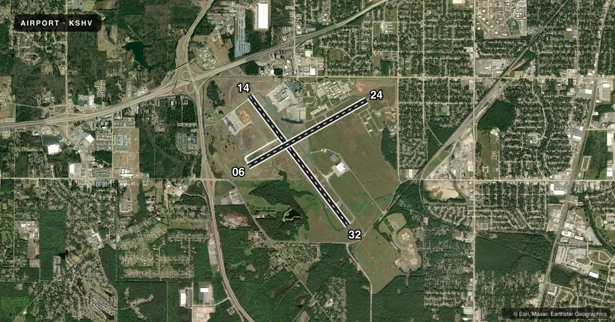
Runways & pattern
Full pagePattern entry · RWY 32
LEFT TRAFFIC| Runway | Heading (°M) | Length | Surface | Traffic |
|---|---|---|---|---|
| 14/32Favored | 141° / 321° | 8,348 ft | ASPH | Standard L |
| 06/24 | 59° / 239° | 7,003 ft | ASPH | Standard L |
Runway end performance
| End | TORA | TODA | ASDA | LDA | VGSI | Approach lights | Obstruction |
|---|---|---|---|---|---|---|---|
| 14 | 8,348' | 8,348' | 8,118' | 8,118' | PAPI 4-box right(3°) | ALSF2 | — |
| 32 | 8,348' | 8,348' | 8,348' | 7,975' | — | MALSR | 32', rr, 920' from thr, 600' R of cntrln, slope 22 |
| 06 | 7,003' | 7,003' | 7,003' | 7,003' | PAPI 4-box left(3°) | — | 77', trees, 2000' from thr, 300' R of cntrln, slope 23 |
| 24 | 7,003' | 7,003' | 7,003' | 7,003' | PAPI 4-box left(3°) | — | 111', trees, 3800' from thr, 0' R of cntrln, slope 32 |
Declared distances in feet. TORA = takeoff run available, TODA = takeoff distance, ASDA = accelerate-stop, LDA = landing distance.
Airport sketch
Runways drawn to scale from FAA survey coordinates, rendered over satellite imagery. Not for navigation.
Approaches & charts
ILS · 3
Services on the field
Fuel grades, oxygen, maintenance, ramp storage and lighting — as declared to the FAA by the airport operator.
Fuel & services
- Fuel
- 100LLA
- Oxygen (bottled)
- High pressure
- Airframe repair
- Major
- Power plant repair
- Major
- Other services
- AFRT,AVNCS,CARGO,CHTR
Ramp & ground
- Transient storage
- Tie-down
- Hangar
- Landing fee
- No fee published
- Customs
- Not available
- Lighting schedule
- SS-SR
- Beacon schedule
- SS-SR
- Beacon
- White / Green (civil land)(WG)
- Wind indicator
- Lighted
- Segmented circle
- No
Fuel & FBOs
Cheapest 100LL and Jet A on the field and nearby. Always confirm with the FBO before taxi.
Airport notes
Surface conditions, obstructions, local procedures, lighting outages and other notes published with each FAA cycle.
General notes
- FLIGHT NOTIFICATION SERVICE (ADCUS) AVBL MON-FRI 0800-1700; OTHER TIMES BY APPOINTMENT CALL 318-635-7873 OR 800-973-2867.
- BIRD ACTIVITY INVOF ARPT.
- SFC COND NOT MNT DLY 0700-1100
Runway surface & condition
- 06/24PCR VALUE: 542/F/B/X/T
- 14/32PCR VALUE: 542/F/B/X/T
Approach & departure obstructions
- 32APCH RATIO 40:1 FM DSPLCD THR.
Other notes
- LNDG FEE FOR ALL COMMERCIAL TFC.
VFR map & nearby airports
VFR sectional. Tap any ICAO chip to open that airport.
Key facts · KSHV
Answer card- ICAO
- KSHV
- Name
- SHREVEPORT RGNL
- Location
- SHREVEPORT, LOUISIANA
- Elevation
- 257.6 ft MSL
- Traffic pattern altitude
- 1,257.6 ft MSL (1,000 AGL)
- Control tower
- Towered · 24
- Total runways
- 2
- Longest runway
- 14/32 · 8,348 ft
- Published ILS approaches
- 3
- Published frequencies
- 11
- Magnetic variation
- 2°
- Current flight rules
- VFR
- Current wind
- 000° at 3 kt
- Favored runway now
- RWY 32
Shreveport Rgnl sits in Shreveport, Louisiana. Field elevation is 257.6 ft MSL. The airport has two asphalt runways. The longest is 14/32 at 8,348 ft. Runway 06/24 is 7,003 ft. The tower is open 24 hours. There are three ILS approaches. They serve runway ends 06, 14 and 32.
Pattern altitude is not published in the facts. Use 1,000 ft AGL for light piston traffic unless ATC or the current Chart Supplement says otherwise. Signature Aviation is on the field. It carries 100LL, Jet A and Jet A Prist. Call (318) 636-1000 for current service details.
A few published remarks matter here. There is a landing fee for commercial traffic. Bird activity is reported near the airport. The surface is not maintained daily between 0700 and 1100. Runway 32 also has a published displaced-threshold approach note. The field is in a busy controlled environment. Expect tower and approach coordination on arrival. Check the current Chart Supplement for any noise or curfew restrictions before flying into the field.