METAR & TAF KRDD
Current METAR
Observed 11:53Z
KRDD 271153Z AUTO 00000KT 10SM CLR 19/08 A2994 RMK AO2 SLP133 T01890078 10278 20189 $
- Wind
- 000° @ 0 kt
- Visibility
- 10 SM
- Temp / Dew
- 19°C / 8°C
- Altimeter
- 29.94 inHg
- Clouds
- CLR
- Density alt
- 1,081 ft
- Ceiling
- Unlimited
- Rules
- VFR
Airport info & contacts
Manager on record, flight service, ARTCC, attendance schedule and pattern altitude — published by the FAA and refreshed every 28 days.
Location
- From city
- 6 NM SE
- VFR sectional
- KLAMATH FALLS
- ARTCC
- ZOA · OAKLAND
- NOTAM facility
- RDD (NOTAM-D)
Airport manager
- Name
- ANDREW SOLSVIG
- Phone
- 530-224-4321
- Address
- 6751 WOODRUM CIRCLE, SUITE 200, REDDING CA 96002
Flight service · Hours
- FSS RIU
- RANCHO MURIETA1-800-WX-BRIEF
- Attendance
- ALL
Frequencies
Tap any row to copy the frequency to your clipboard.
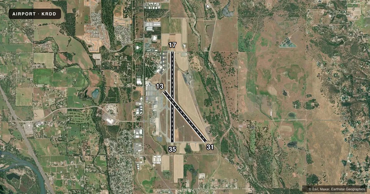
Runways & pattern
Full pagePattern entry · RWY 17
LEFT TRAFFIC| Runway | Heading (°M) | Length | Surface | Traffic |
|---|---|---|---|---|
| 17/35 | 166° / 346° | 7,003 ft | ASPH | Standard L |
| 13/31 | 126° / 306° | 5,067 ft | ASPH | Standard L |
Runway end performance
| End | TORA | TODA | ASDA | LDA | VGSI | Approach lights | Obstruction |
|---|---|---|---|---|---|---|---|
| 17 | 7,003' | 7,003' | 7,003' | 7,003' | PAPI 4-box left(3.43°) | — | 44', tree, 1700' from thr, 650' R of cntrln, slope 34 |
| 35 | 7,003' | 7,003' | 6,997' | 6,997' | PAPI 4-box left(3°) | MALSR | — |
| 13 | 5,067' | 5,067' | 5,067' | 5,067' | — | — | 65', trees, 1600' from thr, 300' R of cntrln, slope 21 |
| 31 | 5,067' | 5,067' | 5,067' | 5,067' | PAPI 2-box left(3°) | — | 88', tree, 2075' from thr, 275' R of cntrln, slope 21 |
Declared distances in feet. TORA = takeoff run available, TODA = takeoff distance, ASDA = accelerate-stop, LDA = landing distance.
Airport sketch
Runways drawn to scale from FAA survey coordinates, rendered over satellite imagery. Not for navigation.
Approaches & charts
ILS · 1
Services on the field
Fuel grades, oxygen, maintenance, ramp storage and lighting — as declared to the FAA by the airport operator.
Fuel & services
- Fuel
- 100LLA
- Oxygen (bottled)
- HIGH/LOW
- Oxygen (bulk)
- HIGH/LOW
- Airframe repair
- Major
- Power plant repair
- Major
- Other services
- AMB,AVNCS,CARGO,CHTR,INSTR,RNTL,SALES
Ramp & ground
- Transient storage
- Tie-down
- Landing fee
- No fee published
- Customs
- Not available
- Lighting schedule
- SEE RMK
- Beacon schedule
- SS-SR
- Beacon
- White / Green (civil land)(WG)
- Wind indicator
- Lighted
- Segmented circle
- Yes
Fuel & FBOs
Cheapest 100LL and Jet A on the field and nearby. Always confirm with the FBO before taxi.
Airport notes
Surface conditions, obstructions, local procedures, lighting outages and other notes published with each FAA cycle.
General notes
- U.S. FOREST SERVICE ON FLD, EXPECT HEAVY AIR TANKER ACTIVITY DURING FIRE SEASON.
- FIELD CONDITIONS RWY; APNS & TWYS GOOD TO FAIR.
- FOR NOISE ABATEMENT AVOID OVERFLIGHTS OF RESIDENTIAL HOUSING WHEN POSSIBLE.
- USE CTN BIRDS INVOF ARPT.
- FOR CD IF UNA TO CTC ON FSS FREQ, CTC OAKLAND ARTCC AT 510-745-3380.
Lighting notes
- ACTVT MALSR RWY 35; REIL RWY 17; PAPI RWY 17; HIRL RWY 17/35; MIRL RWY 13/31; TWY LGTS - CTAF.
Runway surface & condition
- 13/31PCR VALUE: 350/F/C/X/T
- 17/35PCR VALUE: 500/F/B/X/T
- 13/31RWY 13/31 NOT AVBL FOR PART 121/PART 380 OPS WITH SKED PAX CARRYING OPS MORE THAN 9 PAX SEATS AND NON-SKED PAX CARRYING OPS MORE THAN 30 PAX SEATS.
Approach & departure obstructions
- 13MRKGS FADED.
- 17MARKINGS FADED, NOT REFLECTIVE.
- 31MRKGS FADED.
- 35MRKGS FADED, NOT REFLECTIVE.
Other notes
- PPR FOR UNSKED ACR OPNS WITH MORE THAN 30 PSGR SEATS 2130-0630 CALL AMGR (530) 224-4321.
- WIND TEE & WIND CONE COLOCATED IN SEGMENTED CIRCLE.
- MANAGEREMAIL: ASOLSVIG@CITYOFREDDING.ORG
- 13/31SEVERE CRACKING.
- 17/35SEVERE CRACKING.
VFR map & nearby airports
VFR sectional. Tap any ICAO chip to open that airport.
Key facts · KRDD
Answer card- ICAO
- KRDD
- Name
- REDDING RGNL
- Location
- REDDING, CALIFORNIA
- Elevation
- 505 ft MSL
- Traffic pattern altitude
- 1,505 ft MSL (1,000 AGL)
- Control tower
- Towered · 0630-2130
- Total runways
- 2
- Longest runway
- 17/35 · 7,003 ft
- Published ILS approaches
- 1
- Published frequencies
- 6
- Magnetic variation
- 14°
- Current flight rules
- VFR
- Current wind
- 000° at 0 kt
- Favored runway now
- –
Redding Rgnl sits in Redding, California at 505 ft MSL. The field has two asphalt runways. The longest is 16/34 at 7,003 ft. Runway 12/30 is 5,067 ft. The tower is open daily from 0630 to 2130. Outside those hours, check current procedures before you go. There is one ILS approach. It serves runway 34. Pattern altitude is not published. Use 1,000 ft AGL for light piston traffic unless local instructions say otherwise.
Redding Jet Center is on the field. It carries 100LL, Jet A and Jet A Prist. Air Shasta Rotor & Wing is also on the field. It carries 100LL, Jet A and Jet A Prist. The U.S. Forest Service is based here, so expect heavy air tanker activity during fire season. That matters for taxi, ramp flow and radio work. MALSR is active on runway 34. Runway 16 has REIL and a PAPI. Runways 16 and 34 have high intensity lighting. Runways 12 and 30 have medium intensity lighting. Runway 12/30 is not available for certain larger passenger operations. Runway 16/34 has severe cracking. Markings on 12, 16, 30 and 34 are faded in places. For clearance delivery, if you cannot reach flight service, contact Oakland ARTCC. Check the current Chart Supplement for any current restrictions before flying in.