METAR & TAF KPTT
Current METAR
Observed 22:35Z
KPTT 112235Z AUTO 01006KT 10SM CLR 29/07 A2992 RMK AO2 T02910066
- Wind
- 010° @ 6 kt
- Visibility
- 10 SM
- Temp / Dew
- 29°C / 7°C
- Altimeter
- 29.92 inHg
- Clouds
- CLR
- Density alt
- 4,101 ft
- Ceiling
- Unlimited
- Rules
- VFR
Airport info & contacts
Manager on record, flight service, ARTCC, attendance schedule and pattern altitude — published by the FAA and refreshed every 28 days.
Location
- From city
- 4 NM N
- VFR sectional
- WICHITA
- ARTCC
- ZKC · KANSAS CITY
- NOTAM facility
- PTT (NOTAM-D)
Airport manager
- Name
- DEA DIX-BROWN
- Phone
- 620-672-7571
- Address
- 40131 BARKER AVE., PRATT KS 67124
Flight service · Hours
- FSS ICT
- WICHITA1-800-WX-BRIEF
- Attendance
- 0800-SS
Frequencies
Tap any row to copy the frequency to your clipboard.
Runways & pattern
Full pagePattern entry · RWY 35
LEFT TRAFFICRunway end performance
| End | TORA | TODA | ASDA | LDA | VGSI | Approach lights | Obstruction |
|---|---|---|---|---|---|---|---|
| 17 | — | — | — | — | PAPI 2-box left(3°) | — | — |
| 35 | — | — | — | — | PAPI 2-box left(3°) | — | — |
Declared distances in feet. TORA = takeoff run available, TODA = takeoff distance, ASDA = accelerate-stop, LDA = landing distance.
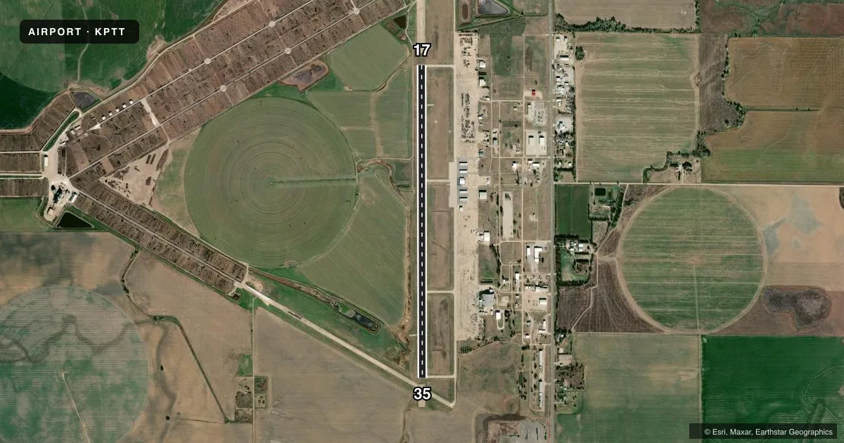
Airport sketch
Runways drawn to scale from FAA survey coordinates, rendered over satellite imagery. Not for navigation.
Approaches & charts
Services on the field
Fuel grades, oxygen, maintenance, ramp storage and lighting — as declared to the FAA by the airport operator.
Fuel & services
- Fuel
- 100LLA
- Oxygen (bottled)
- Not available
- Oxygen (bulk)
- Not available
- Airframe repair
- Major
- Power plant repair
- Major
- Other services
- AGRI,INSTR,RNTL,SURV
Ramp & ground
- Transient storage
- Tie-down
- Hangar
- Landing fee
- No fee published
- Customs
- Not available
- Lighting schedule
- SEE RMK
- Beacon schedule
- SS-SR
- Beacon
- White / Green (civil land)(WG)
- Wind indicator
- Lighted
- Segmented circle
- No
Fuel & FBOs
Cheapest 100LL and Jet A on the field and nearby. Always confirm with the FBO before taxi.
Airport notes
Surface conditions, obstructions, local procedures, lighting outages and other notes published with each FAA cycle.
General notes
- DO NOT MISTAKE LGTD CATTLE PENS FOR LGTD RWYS.
- TWY LGTD.
- CALM WIND RWY 17
- MIGRATING BIRDS ON & INVOF ARPT.
- FOR CD CTC KANSAS CITY ARTCC AT 913-254-8508.
Lighting notes
- DUSK-DAWN. ACTVT REIL RWY 17 & 35; PAPI RWY 17 & 35 - CTAF. MIRL RWY 17/35 PRESET ON LOW INTST, TO INCR INTST & ACTVT - CTAF.
Fuel notes
- 100LLFBO OPS DAYLIGHT HRS. FOR FUEL AFTR HRS CALL 620-886-0289.
Other notes
- THIS AIRPORT HAS BEEN SURVEYED BY THE NATIONAL GEODETIC SURVEY.
VFR map & nearby airports
VFR sectional. Tap any ICAO chip to open that airport.
Key facts · KPTT
Answer card- ICAO
- KPTT
- Name
- PRATT RGNL
- Location
- PRATT, KANSAS
- Elevation
- 1,952.6 ft MSL
- Traffic pattern altitude
- 2,952.6 ft MSL (1,000 AGL)
- Control tower
- Non-towered (use CTAF)
- Total runways
- 1
- Longest runway
- 17/35 · 5,500 ft
- Published ILS approaches
- 0
- Published frequencies
- 2
- Magnetic variation
- 7°
- Current flight rules
- VFR
- Current wind
- 010° at 6 kt
- Favored runway now
- RWY 35
Pratt Rgnl is in Pratt, Kansas. The field elevation is 1,952.6 ft MSL. It has one runway. Runway 17/35 is 5,500 ft long with a concrete surface. The airport is not towered. CTAF and UNICOM are both 122.8. No ILS approaches are published here.
Pattern altitude is not published in the facts. Use the standard 1,000 ft AGL pattern unless the current Chart Supplement says otherwise. Pratt Air is on the field. It carries 100LL and Jet A. The FBO operates during daylight hours. For after-hours fuel, call the number in the Chart Supplement before you go.
A few remarks matter here. Migrating birds are reported on and near the airport. Lighted cattle pens can be mistaken for runway lighting at night. Taxiways are lighted. From dusk to dawn, the REIL and PAPI on runways 17 and 35 are activated by CTAF. The runway lights are preset to low intensity. Use CTAF to increase intensity and activate them. Use runway 17 for calm wind conditions. For clearance delivery, contact Kansas City ARTCC. This is a good field to brief carefully before arrival, especially at night or in reduced visibility.