METAR & TAF KPRC
Current METAR
Observed 12:53Z
KPRC 271253Z 19004KT 10SM CLR 20/15 A3019 RMK AO2 SLP145 T02000150 $
- Wind
- 190° @ 4 kt
- Visibility
- 10 SM
- Temp / Dew
- 20°C / 15°C
- Altimeter
- 30.19 inHg
- Clouds
- CLR
- Density alt
- 6,521 ft
- Ceiling
- Unlimited
- Rules
- VFR
Airport info & contacts
Manager on record, flight service, ARTCC, attendance schedule and pattern altitude — published by the FAA and refreshed every 28 days.
Location
- From city
- 7 NM N
- VFR sectional
- PHOENIX
- ARTCC
- ZAB · ALBUQUERQUE
- NOTAM facility
- PRC (NOTAM-D)
Airport manager
- Name
- RICK CRIDER
- Phone
- 928-777-1114
- Address
- 6630 AIRPORT AVENUE, PRESCOTT AZ 86301
Flight service · Hours
- FSS PRC
- PRESCOTT1-800-WX-BRIEF
- Attendance
- 0600-2200
Frequencies
Tap any row to copy the frequency to your clipboard.
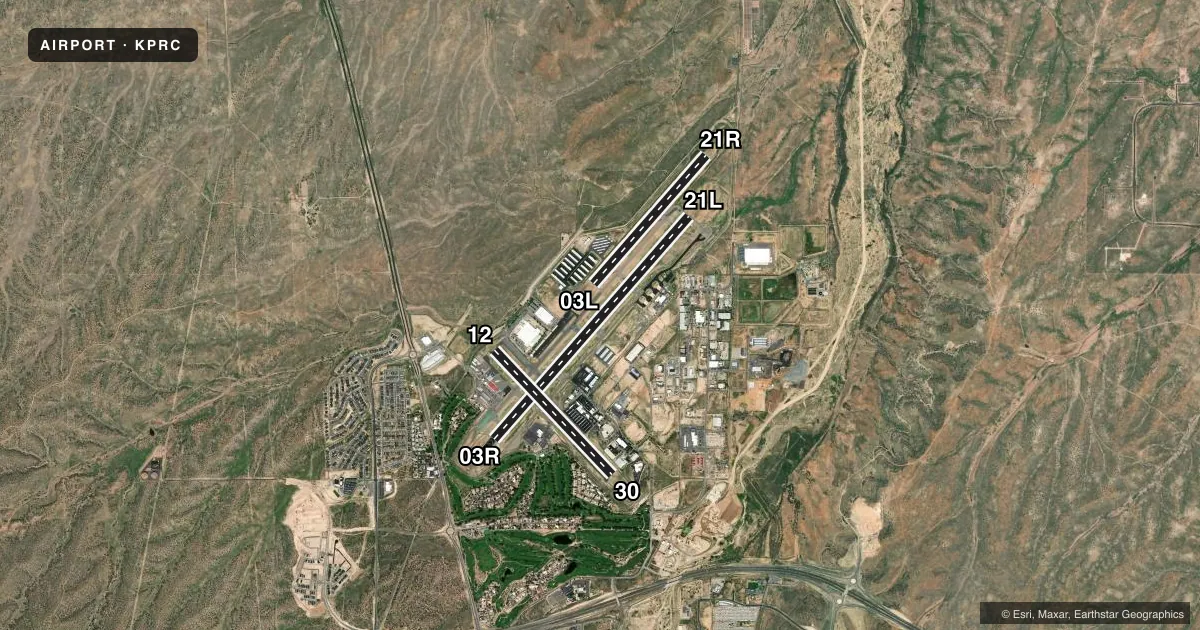
Runways & pattern
Full pagePattern entry · RWY 21L
RIGHT TRAFFIC| Runway | Heading (°M) | Length | Surface | Traffic |
|---|---|---|---|---|
| 03R/21LFavored | 28° / 208° | 7,619 ft | ASPH | 21L R |
| 12/30 | 124° / 304° | 4,408 ft | ASPH | Standard L |
| 03L/21R | 28° / 208° | 4,395 ft | ASPH | 03L R · 21R R |
Runway end performance
| End | TORA | TODA | ASDA | LDA | VGSI | Approach lights | Obstruction |
|---|---|---|---|---|---|---|---|
| 03R | 7,619' | 7,619' | 7,619' | 7,240' | PAPI 4-box left(4.1°) | — | 26', road, 720' from thr, 0' R of cntrln, slope 20 |
| 21L | 7,619' | 7,619' | 7,619' | 7,619' | PAPI 4-box left(3°) | MALSR | — |
| 12 | 4,408' | 4,408' | 4,408' | 4,258' | PAPI 2-box left(4.24°) | — | — |
| 30 | 4,408' | 4,408' | 4,258' | 4,308' | PAPI 2-box left(3.6°) | — | — |
| 03L | — | — | — | — | PAPI 2-box left(3°) | — | — |
| 21R | — | — | — | — | PAPI 2-box left(3°) | — | — |
Declared distances in feet. TORA = takeoff run available, TODA = takeoff distance, ASDA = accelerate-stop, LDA = landing distance.
Airport sketch
Runways drawn to scale from FAA survey coordinates, rendered over satellite imagery. Not for navigation.
Approaches & charts
ILS · 1
Services on the field
Fuel grades, oxygen, maintenance, ramp storage and lighting — as declared to the FAA by the airport operator.
Fuel & services
- Fuel
- 100LLA
- Airframe repair
- Major
- Power plant repair
- Major
- Other services
- AFRT,AVNCS,CARGO,CHTR,INSTR,RNTL,SALES
Ramp & ground
- Transient storage
- Tie-down
- Landing fee
- No fee published
- Customs
- Not available
- Lighting schedule
- SEE RMK
- Beacon schedule
- SS-SR
- Beacon
- White / Green (civil land)(WG)
- Wind indicator
- Lighted
- Segmented circle
- Yes
Fuel & FBOs
Cheapest 100LL and Jet A on the field and nearby. Always confirm with the FBO before taxi.
Airport notes
Surface conditions, obstructions, local procedures, lighting outages and other notes published with each FAA cycle.
General notes
- TSNT, OVNGT PRKG FEE & LNDG FEE - 928-443-9333.
- WILDLIFE ON & INVOF ARPT.
- VOLUNTARY NOISE ABATEMENT PROC IN EFCT - AMGR.
- WINCH TOW UP TO 2500 FT 6 NM E AT A C GOODWIN MEML FLD.
- FICON UNMNT 2200-0600.
- FOR CD WHEN ATCT CLSD, CTC PHOENIX APCH AT 602-306-2565.
- ARFF INDEX B AVBL UPON REQ.
Lighting notes
- WHEN ATCT CLSD: ACTVT MALSR RWY 21L; REIL RWY 03L, 03R, 21R; PAPI RWY 03R & 21L; MIRL 03L, 03R, 21L & 21R - CTAF. ACTVT REIL RWY 12 & 30; PAPI RWY 12 & 30; MIRL RWY 12/30 - 128.75. PAPI RWY 03L & 21R OPR CONSLY.
Fuel notes
- 100LL0600-2100 - 928-443-9333; PPR AFT HR. SELF SVC RSTRD TO WINGSPAN 50 FT OR LESS.
Runway surface & condition
- 03R/21LPCR VALUE: 140/F/D/X/T
- 03L/21RRWY 03L/21R NOT AVBL FOR PART 121/PART 380 OPS WITH SKED PAX CARRYING OPS MORE THAN 9 PAX SEATS AND NON-SKED PAX CARRYING OPS MORE THAN 30 PAX SEATS. CLSD 2200-0600.
- 03R/21LRWY 21L CALM WIND RWY.
- 12/30RWY 12/30 NOT AVBL FOR PART 121/PART 380 OPS WITH SKED PAX CARRYING OPS MORE THAN 9 PAX SEATS AND NON-SKED PAX CARRYING OPS MORE THAN 30 PAX SEATS. USE CTN FOR CHG IN RWY GRADIENT AT RWY 3R/21L INT.
Approach & departure obstructions
- 1220 FT DROPOFF 300 FT FM APCH END.
- 21LDEP RWY HDG TIL ACRS HWY & MAKE IMT L TURN.
- 30RWY 30 PAPI UNUSBL BYD 3 NM.
- 03RAPCH RATIO 20:1 TO DTHR.
Other notes
- TPA FOR LIGHT ACFT ALL RWYS 1000 FT. TPA FOR LARGE ACFT, ALL TURBO PROP/JET AND HIGH PERF ACFT ALL RWYS 1500 FT.
- MANAGERH24 OPS - 928-777-1150.
VFR map & nearby airports
VFR sectional. Tap any ICAO chip to open that airport.
Key facts · KPRC
Answer card- ICAO
- KPRC
- Name
- PRESCOTT RGNL/ERNEST A LOVE FLD
- Location
- PRESCOTT, ARIZONA
- Elevation
- 5,045.2 ft MSL
- Traffic pattern altitude
- 6,045.2 ft MSL (1,000 AGL)
- Control tower
- Towered · 0600-2200
- Total runways
- 3
- Longest runway
- 03R/21L · 7,619 ft
- Published ILS approaches
- 1
- Published frequencies
- 9
- Magnetic variation
- 13°
- Current flight rules
- VFR
- Current wind
- 190° at 4 kt
- Favored runway now
- RWY 21L
Prescott Regional / Ernest A Love Field is in Prescott, Arizona. Field elevation is 5,045.2 ft MSL. The airport has 3 asphalt runways. The longest is 03R/21L at 7,619 ft. The tower is open 0600-2200. One ILS approach is published for runway 21L.
Pattern altitude is not published in the facts. For light piston traffic, use 1,000 ft AGL unless the current Chart Supplement says otherwise. That puts the traffic pattern around 6,045 ft MSL at this field. This is a high-elevation airport. Expect performance to be different from a lowland field. Density altitude can climb fast on warm days.
Cutter Aviation is on the field. It carries 100LL, Jet A and Jet A Prist. Call (928) 443-9333 for current fuel and ramp details. Published remarks also note transient and overnight parking fees. They also note landing fees. Check with the FBO directly for current handling details. Fuel is available from 0600 to 2100. After-hours fuel needs prior permission. Self-service is limited to wingspans of 50 ft or less.
Voluntary noise abatement procedures are in effect. Contact the airport manager before you go if you need the local expectations. Runway 03L/21R is closed from 2200 to 0600. Field condition is unmonitored from 2200 to 0600. When the tower is closed, lighting is activated by CTAF. The airport sits in mountainous central Arizona. Plan for terrain and performance margins on departure and arrival.