METAR & TAF KLNK
Current METAR
Observed 19:54Z
KLNK 271954Z 04008KT 5SM HZ FEW009 36/23 A2979 RMK AO2 SLP071 T03610233
- Wind
- 040° @ 8 kt
- Visibility
- 5 SM
- Temp / Dew
- 36°C / 23°C
- Altimeter
- 29.79 inHg
- Clouds
- FEW
- Density alt
- 4,192 ft
- Ceiling
- Unlimited
- Rules
- MVFR
Airport info & contacts
Manager on record, flight service, ARTCC, attendance schedule and pattern altitude — published by the FAA and refreshed every 28 days.
Location
- From city
- 4 NM NW
- VFR sectional
- OMAHA
- ARTCC
- ZMP · MINNEAPOLIS
- NOTAM facility
- LNK (NOTAM-D)
Airport manager
- Name
- MR. ANTHONY DUDAS
- Phone
- 402-458-2400
- Address
- LINCOLN AIRPORT AUTHORITY, P.O. BOX 80407, LINCOLN NE 68501
Flight service · Hours
- FSS OLU
- COLUMBUS1-800-WX-BRIEF
- Attendance
- ALL
Frequencies
Tap any row to copy the frequency to your clipboard.
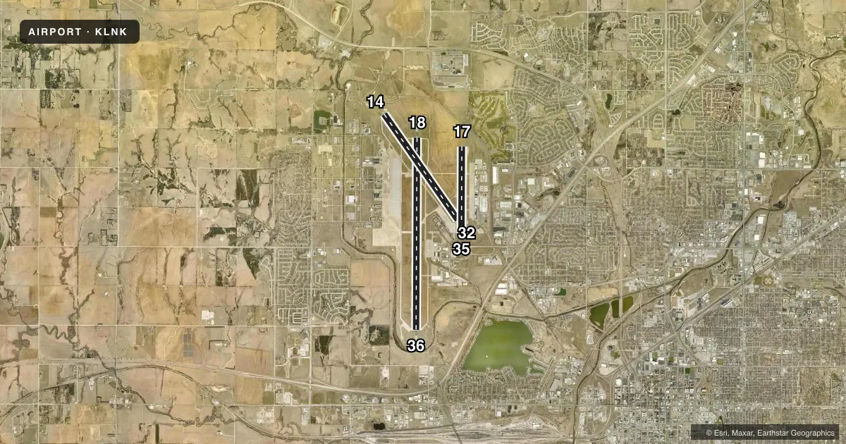
Runways & pattern
Full pagePattern entry · RWY 36
LEFT TRAFFIC| Runway | Heading (°M) | Length | Surface | Traffic |
|---|---|---|---|---|
| 18/36Favored | 177° / 357° | 12,901 ft | ASPH-CONC | 18 R |
| 14/32 | 142° / 322° | 8,649 ft | ASPH | Standard L |
| 17/35 | 177° / 357° | 5,801 ft | ASPH | 35 R |
Runway end performance
| End | TORA | TODA | ASDA | LDA | VGSI | Approach lights | Obstruction |
|---|---|---|---|---|---|---|---|
| 18 | 12,901' | 12,901' | 12,901' | 12,901' | PAPI 4-box left(3°) | MALSR | — |
| 36 | 12,901' | 12,901' | 12,901' | 12,901' | PAPI 4-box left(3°) | MALSR | — |
| 14 | 8,649' | 8,649' | 8,649' | 8,286' | PAPI 4-box left(3°) | — | — |
| 32 | 8,649' | 8,649' | 8,286' | 7,816' | VASI 4-box left(3°) | — | 59', pole, 2475' from thr, 375' R of cntrln, slope 38 |
| 17 | 5,800' | 5,800' | 5,400' | 5,400' | PAPI 4-box left(3°) | — | — |
| 35 | 5,800' | 5,800' | 5,800' | 5,800' | PAPI 4-box left(3°) | ODALS | — |
Declared distances in feet. TORA = takeoff run available, TODA = takeoff distance, ASDA = accelerate-stop, LDA = landing distance.
Airport sketch
Runways drawn to scale from FAA survey coordinates, rendered over satellite imagery. Not for navigation.
Approaches & charts
ILS · 2
Services on the field
Fuel grades, oxygen, maintenance, ramp storage and lighting — as declared to the FAA by the airport operator.
Fuel & services
- Fuel
- 100LLA
- Oxygen (bottled)
- HIGH/LOW
- Oxygen (bulk)
- High pressure
- Airframe repair
- Major
- Power plant repair
- Major
- Other services
- AFRT,AMB,AVNCS,CARGO,CHTR,INSTR,RNTL,SALES,SURV
Ramp & ground
- Transient storage
- Tie-down
- Hangar
- Landing fee
- No fee published
- Customs
- Not available
- Lighting schedule
- SEE RMK
- Beacon schedule
- SS-SR
- Beacon
- White / Green (civil land)(WG)
- Wind indicator
- Lighted
- Segmented circle
- No
Fuel & FBOs
Cheapest 100LL and Jet A on the field and nearby. Always confirm with the FBO before taxi.
Airport notes
Surface conditions, obstructions, local procedures, lighting outages and other notes published with each FAA cycle.
General notes
- BIRDS INVOF ARPT.
- PPR TO PARK ON ANG RAMP.
- ANG: CTC AM OPS 234.65 20 MIN PRIOR TO LDG.
- ANG: PROVISIONAL PORT OF ENTRY: US CUSTOMS AVBL ONLY WITH 24 HR NOTICE AND ONLY FOR DOD AIRCREW AND DOD DUTY PAX ON TRAVEL ORDERS. CTC COMD POST. SPACE-A US CUSTOMS ENTRY TO THE US AT THIS ARPT LIMITED TO ACTIVE DUTY MILITARY PERSONNEL ON LEAVE (NO DEPENDENTS).
- ARNG: OPR 1300-2100Z++ TUE-FRI, LTD TRAN MAINT.
- ARNG: RAMP IS OFFL BUS/PPR TO PRK ARNG RAMP CTC FLT OPS DSN 279-1844, C402-309-1844.
- ENSURE CORRECT RWY LINEUP. RWY 17/35 IS THE SHRTR, PARL RWY ON E SIDE OF ARPT.
- ANG: AM OPS DSN 279-1293; C402-309-1293.
- PPR 24 HRS FOR ACFT PARKING ON THE WEST RAMP - CTC ARPT 402-458-2480.
- ANG: CTC AM OPS 234.65 FOR BWC.
- FOR CD WHEN ATCT IS CLSD CTC OMAHA APCH AT 402-682-4395.
- AF: USAF TMPRY OPS ON WEST RAMP FR APRX SPRING 2021 TO FALL 2022.
Lighting notes
- WHEN ATCT CLSD, MALSR RWYS 18 & 36 OPR CONSLY ON LOW INTST; ODALS RWY 35 OPR CONSLY ON MED INTST; REIL RWY 14 OPR CONSLY ON LOW INTST; REIL RWY 17 OPR CONSLY ON MED INTST; MIRL RWY 14/32 AND RWY 17/35 OPR CONSLY ON LOW INTST; HIRL RWY 18/36 OPR CONSLY ON MED INTST. VASI RWY 32; PAPI RWYS 14, 17, 18, 35, & 36 OPR CONSLY.
Runway surface & condition
- 14/32PCR VALUE: 450/F/B/X/U
- 17/35PCR VALUE: 140/R/C/W/T
- 18/36PCR VALUE: 672/R/B/W/U
Approach & departure obstructions
- 18CALM WIND RWY.
- 32APCH HOLDLINE ON SOUTH TWY A.
- 32VASI UNUSBL BYD 8 DEGS LEFT OF CNTRLN AND 6 DEGS RIGHT OF CNTRLN.
- 32APCH RATIO FM DTHR 49:1.
Other notes
- INDEX C LVL ARFF EQPT PRVDD; FOR ARFF SVC - CTAF.
- HVY MIL JET TPA 1781 FT AGL
- MANAGEREXECUTIVE DIRECTOR.
VFR map & nearby airports
VFR sectional. Tap any ICAO chip to open that airport.
Key facts · KLNK
Answer card- ICAO
- KLNK
- Name
- LINCOLN
- Location
- LINCOLN, NEBRASKA
- Elevation
- 1,218.7 ft MSL
- Traffic pattern altitude
- 2,218.7 ft MSL (1,000 AGL)
- Control tower
- Towered · 0600 - 2200
- Total runways
- 3
- Longest runway
- 18/36 · 12,901 ft
- Published ILS approaches
- 2
- Published frequencies
- 15
- Magnetic variation
- 3°
- Current flight rules
- MVFR
- Current wind
- 040° at 8 kt
- Favored runway now
- RWY 36
Lincoln Airport is in Lincoln, Nebraska. The field elevation is 1,218.7 ft MSL. It has three runways. The longest is 18/36 at 12,901 ft. The airport is towered from 0600 to 2200 local. Two ILS approaches serve runway ends 18 and 36. The published pattern altitude is not listed, so use standard 1,000 ft AGL for light piston traffic unless the current Chart Supplement says otherwise.
This is a busy field with multiple paved runways and a long primary north-south strip. Runway 18/36 is the calm wind runway. The airport remarks also call out birds in the vicinity, so keep a sharp scan on arrival and departure. When the tower is closed, the lighting setup stays usable. The MALSR on 18 and 36 operates continuously on low intensity. The HIRL on 18/36 operates continuously on medium intensity. The PAPI on 14, 17, 18, 35 and 36 also operates continuously.
Atlantic Aviation is on the field with AVGAS 100LL and Jet A. Duncan Aviation is on the field with AVGAS 100LL, Jet A and Jet A Prist. If you are planning to use the ANG ramp, prior permission is required. The airport also notes correct runway lineup is important. Runway 17/35 is the shorter parallel runway on the east side of the airport. For current noise, ramp, or access details, check the current FAA Chart Supplement or call the airport operator or FBO directly.