METAR & TAF KIFP
Current METAR
Observed 23:48Z
KIFP 262348Z 22015KT 10SM CLR 46/09 A2973
- Wind
- 220° @ 15 kt
- Visibility
- 10 SM
- Temp / Dew
- 46°C / 9°C
- Altimeter
- 29.73 inHg
- Clouds
- CLR
- Density alt
- 4,832 ft
- Ceiling
- Unlimited
- Rules
- VFR
Airport info & contacts
Manager on record, flight service, ARTCC, attendance schedule and pattern altitude — published by the FAA and refreshed every 28 days.
Location
- From city
- 1 NM N
- VFR sectional
- PHOENIX
- ARTCC
- ZLA · LOS ANGELES
- NOTAM facility
- IFP (NOTAM-D)
Airport manager
- Name
- JAMES SCHELLER
- Phone
- 928-754-2134 X24
- Address
- 2550 LAUGHLIN VIEW DR, BULLHEAD CITY AZ 86429
Flight service · Hours
- FSS PRC
- PRESCOTT1-800-WX-BRIEF
- Attendance
- ALL
Frequencies
Tap any row to copy the frequency to your clipboard.
Runways & pattern
Full pagePattern entry · RWY 16
RIGHT TRAFFICRunway end performance
| End | TORA | TODA | ASDA | LDA | VGSI | Approach lights | Obstruction |
|---|---|---|---|---|---|---|---|
| 16 | 8,500' | 8,500' | 8,500' | 8,500' | PAPI 4-box left(3.13°) | — | 123', pole, 3200' from thr, 550' R of cntrln, slope 24 |
| 34 | 8,500' | 8,500' | 8,500' | 8,500' | PAPI 4-box left(3°) | — | — |
Declared distances in feet. TORA = takeoff run available, TODA = takeoff distance, ASDA = accelerate-stop, LDA = landing distance.
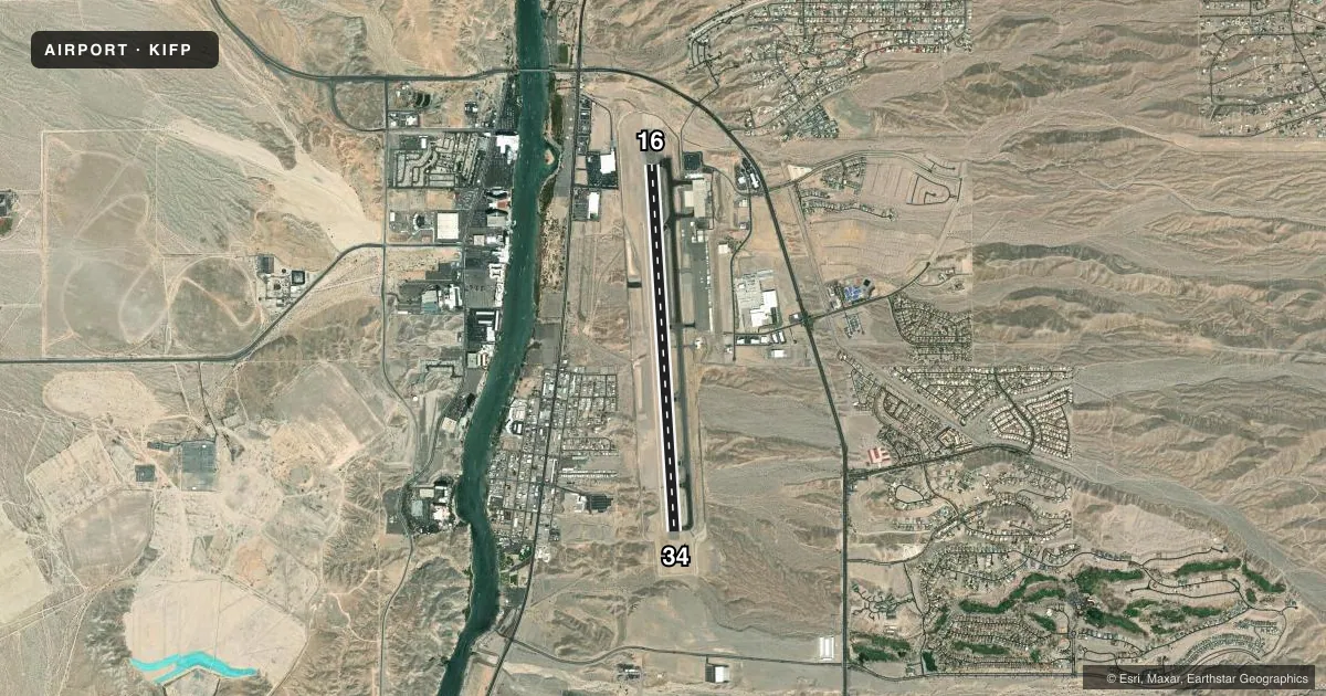
Airport sketch
Runways drawn to scale from FAA survey coordinates, rendered over satellite imagery. Not for navigation.
Approaches & charts
Services on the field
Fuel grades, oxygen, maintenance, ramp storage and lighting — as declared to the FAA by the airport operator.
Fuel & services
- Fuel
- 100LLA
- Oxygen (bulk)
- HIGH/LOW
- Other services
- AFRT,AMB,CHTR
Ramp & ground
- Transient storage
- Tie-down
- Hangar
- Landing fee
- No fee published
- Customs
- Not available
- Lighting schedule
- SEE RMK
- Beacon schedule
- SS-SR
- Beacon
- White / Green (civil land)(WG)
- Wind indicator
- Lighted
- Segmented circle
- Yes
Fuel & FBOs
Cheapest 100LL and Jet A on the field and nearby. Always confirm with the FBO before taxi.
Airport notes
Surface conditions, obstructions, local procedures, lighting outages and other notes published with each FAA cycle.
General notes
- MTNS NW, NE, E AND SE. RISING TRRN N & S OF RWY ENDS.
- TPA FOR LIGHT ACFT 999 FT AGL, TPA FOR HIGH PERFORMANCE ACFT 1499 FT AGL.
- TWY ALPHA 4 LTD TO WINGSPANS LESS THAN 79 FT.
- CTN: LRG COML OPS AFT ATCT HRS; BIRDS ON & INVOF ARPT SEP-DEC.
- NOISE SENSITIVE AREAS NE & SE.
- SFC COND UNMNT 0600Z-1200Z.
- TWY A5 BTN TWY A & GEN AVN APRON LTD TO WINGSPAN LESS THAN 79 FT.
- RADAR SVC BLW 6000 FT NA.
- GA LNDG FEE - 928-754-2134.
Lighting notes
- ACTVT REIL RWY 16 & 34; PAPI RWY 16 & 34; MIRL RWY 16/34 - CTAF.
Runway surface & condition
- 16/34PCR VALUE: 480/F/A/X/T
Approach & departure obstructions
- 1666 FT PLINE PARL TO RWY 625 FT L 1300 FT FM RWY END.
- 34PAPI UNUSBL BYD 7 DEGS RIGHT OF CNTRLN.
Other notes
- ESTABD PRIOR TO 1959.
- 1SVCS & FUEL 0600-2200 - 122.85; AFT HR NA.
- MANAGER941-323-2178.
VFR map & nearby airports
VFR sectional. Tap any ICAO chip to open that airport.
Key facts · KIFP
Answer card- ICAO
- KIFP
- Name
- LAUGHLIN/BULLHEAD INTL
- Location
- BULLHEAD CITY, ARIZONA
- Elevation
- 707.1 ft MSL
- Traffic pattern altitude
- 1,707.1 ft MSL (1,000 AGL)
- Control tower
- Towered · 0800-1800
- Total runways
- 1
- Longest runway
- 16/34 · 8,501 ft
- Published ILS approaches
- 0
- Published frequencies
- 4
- Magnetic variation
- 12°
- Current flight rules
- VFR
- Current wind
- 220° at 15 kt
- Favored runway now
- RWY 16
Laughlin/Bullhead Intl sits in Bullhead City, Arizona. Field elevation is 707.1 ft MSL. The airport has one runway. Runway 16/34 is 8,501 ft long. The tower is open 0800-1800. No ILS approaches are published here. Pattern altitude for light aircraft is 999 ft AGL. That puts the light-aircraft pattern at 1,706.1 ft MSL.
Touch & Go FBO is on the field. It carries 100LL, Jet A and Jet A Prist. If you need fuel or ramp help, call them at (928) 754-3020 before you roll in. The published remarks also note that services and fuel are available from 0600 to 2200 on frequency 122.85. After hours, they are not available.
A few operational items matter here. Taxiway A5 between taxiway A and the general aviation apron is limited to wingspan less than 79 feet. The precision approach path indicator on runway 34 is unusable beyond 7 degrees right of centerline. There is also a 66 ft power line near runway 16, left of centerline and close to the departure end. Radar service below 6,000 ft is not available. Plan your arrival and departure with that in mind. The field has medium intensity runway lights on 16/34. Runway end identifier lights and PAPI are on both ends.