METAR & TAF KFSM
Current METAR
Observed 17:53Z
KFSM 271753Z 10SM CLR 36/21 A2991 RMK AO2 SLP122 T03610211 10367 20267 58013
- Wind
- Calm
- Visibility
- 10 SM
- Temp / Dew
- 36°C / 21°C
- Altimeter
- 29.91 inHg
- Clouds
- CLR
- Density alt
- 3,114 ft
- Ceiling
- Unlimited
- Rules
- VFR
Airport info & contacts
Manager on record, flight service, ARTCC, attendance schedule and pattern altitude — published by the FAA and refreshed every 28 days.
Location
- From city
- 3 NM SE
- VFR sectional
- MEMPHIS
- ARTCC
- ZME · MEMPHIS
- NOTAM facility
- FSM (NOTAM-D)
Airport manager
- Name
- MICHAEL GRIFFIN
- Phone
- 479-650-3304
- Address
- 6700 MC KENNON BLVD SUITE 200, FORT SMITH AR 72903
Flight service · Hours
- FSS JBR
- JONESBORO1-800-WX-BRIEF
- Attendance
- ALL
Frequencies
Tap any row to copy the frequency to your clipboard.
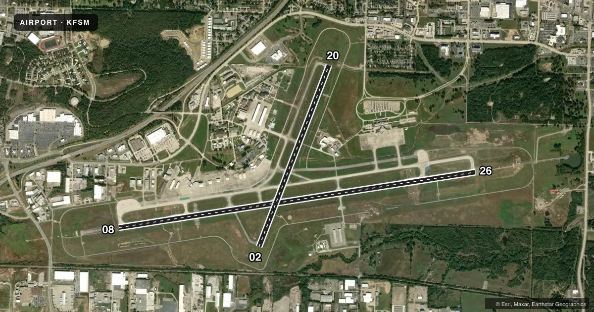
Runways & pattern
Full pagePattern entry · RWY 08
LEFT TRAFFIC| Runway | Heading (°M) | Length | Surface | Traffic |
|---|---|---|---|---|
| 08/26 | 80° / 260° | 9,318 ft | ASPH | Standard L |
| 02/20 | 20° / 200° | 5,001 ft | ASPH | Standard L |
Runway end performance
| End | TORA | TODA | ASDA | LDA | VGSI | Approach lights | Obstruction |
|---|---|---|---|---|---|---|---|
| 08 | — | — | — | — | PAPI 4-box right(3°) | MALSR | 78', tree, 2102' from thr, 692' R of cntrln, slope 24 |
| 26 | — | — | — | — | PAPI 4-box left(3°) | MALSR | 96', tree, 2610' from thr, 1032' R of cntrln, slope 25 |
| 02 | 5,001' | 5,001' | 5,001' | 5,001' | PAPI 4-box right(3°) | — | 21', rr, 640' from thr, 313' R of cntrln, slope 20 |
| 20 | 5,001' | 5,001' | 5,001' | 5,001' | PAPI 4-box left(3°) | — | 56', tree, 1495' from thr, 365' R of cntrln, slope 23 |
Declared distances in feet. TORA = takeoff run available, TODA = takeoff distance, ASDA = accelerate-stop, LDA = landing distance.
Airport sketch
Runways drawn to scale from FAA survey coordinates, rendered over satellite imagery. Not for navigation.
Approaches & charts
ILS · 2
Services on the field
Fuel grades, oxygen, maintenance, ramp storage and lighting — as declared to the FAA by the airport operator.
Fuel & services
- Fuel
- 100LLA
- Oxygen (bottled)
- Not available
- Oxygen (bulk)
- Not available
- Airframe repair
- Major
- Power plant repair
- Major
- Other services
- AFRT,AVNCS,CHTR,INSTR
Ramp & ground
- Transient storage
- Tie-down
- Hangar
- Landing fee
- No fee published
- Customs
- Not available
- Lighting schedule
- SEE RMK
- Beacon schedule
- SS-SR
- Beacon
- White / Green (civil land)(WG)
- Wind indicator
- Lighted
- Segmented circle
- Yes
Fuel & FBOs
Cheapest 100LL and Jet A on the field and nearby. Always confirm with the FBO before taxi.
Airport notes
Surface conditions, obstructions, local procedures, lighting outages and other notes published with each FAA cycle.
General notes
- LNDG FEE FOR ALL FAR 121 & FAR 135 OPNS ABOVE 12,500 LBS.
- PPR FOR ALL ACFT (INCLUDING US GOVT) ABOVE 100,000 LBS. CTC AMGR 0800-1700 MON-FRI 479-452-7000; MINIMUM 24 HRS IN ADVANCE.
- FLOCK OF MIGRATORY BIRDS ON & INVOF ARPT.
- RWY 02 AIMING POINTS 1390 FT FM THLD.
- FOR CD CTC MEMPHIS ARTCC AT 901-368-8453/8449.
- A-GEAR - RWY 08 AND RWY 26 BAK-14 IN-GN BARRIER HOUSINGS LCTD 275 FT CNTRLN.
- A-GEAR UNAVBL WHEN TWR CLSD.
- A-GEAR - RWY 08 BAK-12 ABV GND 2000 FT FM RWY 08 THLD.
- ANG - PPR MIN 72 HRS NOTICE RQRD, CTC AFLD MGMT C479-573-5925/5352.
Lighting notes
- WHEN ATCT CLSD ACTVT MALSR RWY 08 & 26; MIRL RWY 02/20; HIRL RWY 08/26 - CTAF.
Fuel notes
- 100LL100LL AVBL 24 HRS SELF SERVE. FOR JET A SAT & SUN 2200-0600, CALL 479-646-1611.
Runway surface & condition
- 02/20PCR VALUE: 425/F/D/X/T
- 08/26PCR VALUE: 470/F/C/W/T
Approach & departure obstructions
- 02PAPI UNUSBL BYD 8 DEGS LEFT OF CNTRLN.
- 20PAPI UNUSBL BYD 5 DEGS RIGHT OF CNTRLN.
Arresting gear
- 08_BAK-14BAK-14 BAK-12B(B) (1500')
- 26_BAK-14BAK-14 BAK-12B(B) (1651')
Other notes
- 24 HRS PPR FOR UNSKED ACR OPNS WITH MORE THAN 30 PSGR SEATS CALL AMGR 479-452-7000.
- MANAGERMICHAEL@FORTSMITHAIRPORT.COM
VFR map & nearby airports
VFR sectional. Tap any ICAO chip to open that airport.
Key facts · KFSM
Answer card- ICAO
- KFSM
- Name
- FORT SMITH RGNL
- Location
- FORT SMITH, ARKANSAS
- Elevation
- 469 ft MSL
- Traffic pattern altitude
- 1,469 ft MSL (1,000 AGL)
- Control tower
- Towered · 0530-2300
- Total runways
- 2
- Longest runway
- 08/26 · 9,318 ft
- Published ILS approaches
- 2
- Published frequencies
- 19
- Magnetic variation
- 1°
- Current flight rules
- VFR
- Current wind
- Calm / unavailable
- Favored runway now
- –
Fort Smith Regional Airport is in Fort Smith, Arkansas. The field elevation is 469 ft MSL. It has two asphalt runways. The longest is 9,318 ft on 08/26. The tower is open daily from 0530 to 2300. Two ILS approaches are published for runway ends 08 and 26. Pattern altitude is not published in the facts, so use the current Chart Supplement before you go.
Signature Aviation is on the field. It carries 100LL and Jet A. Fort Smith Regional Airport is also listed as an on-field FBO. It carries 100LL. 100LL is available 24 hours self-serve. If you need Jet A on Saturday or Sunday from 2200 to 0600, call Signature Aviation first.
This is a busy controlled field with TRSA services and published approach control. Clearance delivery goes through Memphis ARTCC. Runway 08/26 is the long option. Runway 02/20 is shorter at 5,001 ft. There are published PAPI limits on both ends of 02/20, plus a BAK-12 obstruction near the approach end of 08. Check the current Chart Supplement for any noise or curfew restrictions before flying in. If you are planning a larger aircraft, review the published prior permission notes before arrival.