METAR & TAF KFNL
Current METAR
Observed 18:56Z
KFNL 271856Z VRB04KT 10SM SCT120 31/14 A3016 RMK AO2 SLP127 T03110139 $
- Wind
- VAR @ 4 kt
- Visibility
- 10 SM
- Temp / Dew
- 31°C / 14°C
- Altimeter
- 30.16 inHg
- Clouds
- SCT
- Density alt
- 7,848 ft
- Ceiling
- Unlimited
- Rules
- VFR
Airport info & contacts
Manager on record, flight service, ARTCC, attendance schedule and pattern altitude — published by the FAA and refreshed every 28 days.
Location
- From city
- 9 NM SE
- VFR sectional
- CHEYENNE
- ARTCC
- ZDV · DENVER
- NOTAM facility
- FNL (NOTAM-D)
Airport manager
- Name
- JOHN KINNEY
- Phone
- 970-962-2852
- Address
- 4900 EARHART ROAD, LOVELAND CO 80538
Flight service · Hours
- FSS DEN
- DENVER1-800-WX-BRIEF
- Attendance
- ALL
Frequencies
Tap any row to copy the frequency to your clipboard.
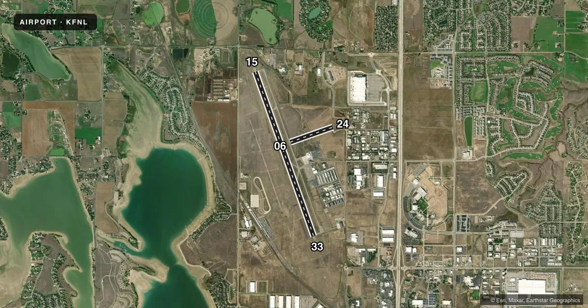
Runways & pattern
Full pagePattern entry · RWY 33
LEFT TRAFFIC| Runway | Heading (°M) | Length | Surface | Traffic |
|---|---|---|---|---|
| 15/33Favored | 151° / 331° | 8,500 ft | ASPH | Standard L |
| 06/24 | 62° / 242° | 2,189 ft | ASPH | Standard L |
Runway end performance
| End | TORA | TODA | ASDA | LDA | VGSI | Approach lights | Obstruction |
|---|---|---|---|---|---|---|---|
| 15 | 8,500' | 8,500' | 8,500' | 8,500' | PAPI 4-box left(3°) | — | — |
| 33 | 8,500' | 8,500' | 8,500' | 8,500' | PAPI 4-box left(3°) | MALSR | — |
| 06 | 2,189' | 2,189' | 2,189' | 2,189' | — | — | — |
| 24 | 2,189' | 2,189' | 2,189' | 2,189' | — | — | — |
Declared distances in feet. TORA = takeoff run available, TODA = takeoff distance, ASDA = accelerate-stop, LDA = landing distance.
Airport sketch
Runways drawn to scale from FAA survey coordinates, rendered over satellite imagery. Not for navigation.
Approaches & charts
ILS · 1
Services on the field
Fuel grades, oxygen, maintenance, ramp storage and lighting — as declared to the FAA by the airport operator.
Fuel & services
- Fuel
- 100LLA
- Contract fuel
- Available
- Oxygen (bulk)
- HIGH/LOW
- Airframe repair
- Major
- Power plant repair
- Major
- Other services
- CHTR,INSTR,RNTL,SALES,SURV
Ramp & ground
- Transient storage
- Tie-down
- Hangar
- Landing fee
- No fee published
- Customs
- Not available
- Lighting schedule
- SEE RMK
- Beacon schedule
- SS-SR
- Beacon
- White / Green (civil land)(WG)
- Wind indicator
- Lighted
- Segmented circle
- Yes
Fuel & FBOs
Cheapest 100LL and Jet A on the field and nearby. Always confirm with the FBO before taxi.
Airport notes
Surface conditions, obstructions, local procedures, lighting outages and other notes published with each FAA cycle.
General notes
- RSCD UNMON 0500-1300Z++
- FOR CD CTC DENVER APCH AT 303-342-1916.
- RWY 24 THLD NOT VISIBLE BY TWR.
Lighting notes
- DUSK-DAWN: ACTVT MALSR RWY 33; REIL RWY 15; PAPI RWY 33; HIRL RWY 15/33; TWY LGTS - CTAF. PAPI RWY 15 ON CONSLY.
Fuel notes
- 100LLH24 WITH CREDIT CARD.
- AH24 WITH CREDIT CARD.
Runway surface & condition
- 15/33PCR VALUE: 581/F/D/X/T
- 06/24EDGE REFLECTORS FULL LEN.
- 15/33RWY 33 CALM WIND RWY 5 KTS OR LESS.
Approach & departure obstructions
- 06CONC HEADWALL 43 FT L & R OF CNTRLN 815 FT FM THR.
- 242 - 4 FT DITCH WI 55 FT L & R OF CNTRLN FULL LEN.
Other notes
- 24 HR PPR FOR UNSKED OPS WITH MORE THAN 30 PAX SEATS - AMGR.
- 1SVC - 130.575 OR 970-667-2574.
VFR map & nearby airports
VFR sectional. Tap any ICAO chip to open that airport.
Key facts · KFNL
Answer card- ICAO
- KFNL
- Name
- NORTHERN COLORADO RGNL
- Location
- FORT COLLINS/LOVELAND, COLORADO
- Elevation
- 5,020.3 ft MSL
- Traffic pattern altitude
- 6,020.3 ft MSL (1,000 AGL)
- Control tower
- Towered · 1500-0100Z++
- Total runways
- 2
- Longest runway
- 15/33 · 8,500 ft
- Published ILS approaches
- 1
- Published frequencies
- 7
- Magnetic variation
- 9°
- Current flight rules
- VFR
- Current wind
- 000° at 4 kt
- Favored runway now
- RWY 33
Northern Colorado Rgnl sits in Fort Collins/Loveland, Colorado. Field elevation is 5,020.3 ft MSL. The airport has two asphalt runways. The longest is runway 15/33 at 8,500 ft. Runway 06/24 is 2,189 ft. The field is towered. Tower hours are 1500-0100Z++. For clearance delivery, Denver Approach handles that task. The airport has one ILS approach. It serves runway 33.
Pattern altitude is not published in the facts. Use the current Chart Supplement before you fly. The field is at high elevation, so performance planning matters. Expect density altitude to be a real factor in warm weather. Runway 33 is listed as the calm wind runway for winds 5 knots or less. That is useful when the wind is light.
jetCenters of Colorado is on the field. It carries 100LL, Jet A and Jet A Prist. Fuel is available 24 hours with credit card. Runway 24 has a ditch close to the centerline along its length. Runway 06 has a concrete headwall near the threshold. Runway 24 threshold is not visible from the tower. Taxiway lights are controlled by CTAF. If you are new to the airport, brief the lighting and runway environment before arrival.