METAR & TAF KEKO
Current METAR
Observed 15:56Z
KEKO 271556Z AUTO 25005KT 10SM CLR 27/M06 A3013 RMK AO2 SLP133 T02671056
- Wind
- 250° @ 5 kt
- Visibility
- 10 SM
- Temp / Dew
- 27°C / -6°C
- Altimeter
- 30.13 inHg
- Clouds
- CLR
- Density alt
- 7,553 ft
- Ceiling
- Unlimited
- Rules
- VFR
Airport info & contacts
Manager on record, flight service, ARTCC, attendance schedule and pattern altitude — published by the FAA and refreshed every 28 days.
Location
- From city
- 1 NM W
- VFR sectional
- SALT LAKE CITY
- ARTCC
- ZLC · SALT LAKE CITY
- NOTAM facility
- EKO (NOTAM-D)
Airport manager
- Name
- JAMES FOSTER
- Phone
- 775-777-7194
- Address
- 975 TERMINAL WAY, ELKO NV 89801
Flight service · Hours
- FSS RNO
- RENO1-800-WX-BRIEF
- Attendance
- 0500-2100
Frequencies
Tap any row to copy the frequency to your clipboard.
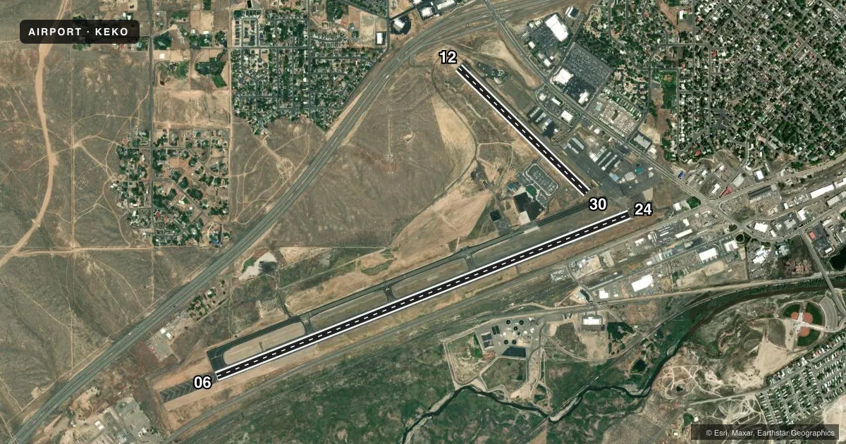
Runways & pattern
Full pagePattern entry · RWY 24
LEFT TRAFFIC| Runway | Heading (°M) | Length | Surface | Traffic |
|---|---|---|---|---|
| 06/24Favored | 57° / 237° | 7,454 ft | ASPH | 06 R |
| 12/30 | 122° / 302° | 3,015 ft | ASPH | 12 R |
Runway end performance
| End | TORA | TODA | ASDA | LDA | VGSI | Approach lights | Obstruction |
|---|---|---|---|---|---|---|---|
| 06 | 7,217' | 7,217' | 7,217' | 7,217' | PAPI 4-box left(3°) | — | 24', road, 700' from thr, 325' R of cntrln, slope 20 |
| 24 | 7,454' | 7,454' | 7,454' | 6,418' | PAPI 4-box left(3.25°) | MALSR | 99', pole, 2300' from thr, 450' R of cntrln, slope 21 |
| 12 | 3,015' | 3,015' | 3,015' | 2,109' | — | — | 26', pole, 650' from thr, 75' R of cntrln, slope 17 |
| 30 | 3,015' | 3,015' | 3,015' | 2,872' | — | — | 30', pole, 900' from thr, 100' R of cntrln, slope 23 |
Declared distances in feet. TORA = takeoff run available, TODA = takeoff distance, ASDA = accelerate-stop, LDA = landing distance.
Airport sketch
Runways drawn to scale from FAA survey coordinates, rendered over satellite imagery. Not for navigation.
Approaches & charts
ILS · 1
Services on the field
Fuel grades, oxygen, maintenance, ramp storage and lighting — as declared to the FAA by the airport operator.
Fuel & services
- Fuel
- 100LLA
- Oxygen (bottled)
- Not available
- Oxygen (bulk)
- HIGH/LOW
- Airframe repair
- Major
- Power plant repair
- Major
- Other services
- AMB,CARGO,CHTR,INSTR,RNTL
Ramp & ground
- Transient storage
- Tie-down
- Hangar
- Landing fee
- No fee published
- Customs
- Not available
- Lighting schedule
- SEE RMK
- Beacon schedule
- SS-SR
- Beacon
- White / Green (civil land)(WG)
- Wind indicator
- Lighted
- Segmented circle
- Yes
Fuel & FBOs
Cheapest 100LL and Jet A on the field and nearby. Always confirm with the FBO before taxi.
Airport notes
Surface conditions, obstructions, local procedures, lighting outages and other notes published with each FAA cycle.
General notes
- RWY 24 DESIGNATED CALM WIND RWY.
- PPR FOR ALL ACFT OPNS OVER 100000 LBS CALL 775-777-7190.
- TKOF ONLY ON RWY 12. LAND ONLY ON RWY 30.
- NO TGL RWY 12/30.
- STEEP SLOPE/GRADIENT RWY 30 UPWARD.
- SFC CONDS NOT MNT DLY 0500-1400Z.
- FOR CD IF UNA TO CTC ON FSS FREQ, CTC SALT LAKE ARTCC AT 801-320-2568.
- COLD TEMPERATURE AIRPORT. ALTITUDE CORRECTION REQUIRED AT OR BELOW -25C.
- INCD BIRD ACT INVOF ARPT MAR-SEP.
Lighting notes
- ACTVT MALSR RWY 24; MIRL RWY 06/24 - CTAF. PAPI RWY 06 & 24 ON CONSLY.
Fuel notes
- 100LL100LL, A AVAILABLE 24/7.
Runway surface & condition
- 06/24PCR VALUE: 340/F/B/X/T
- 12/30PCR VALUE: 50/F/C/X/T
- 12/30RWY 12/30 NOT AVBL FOR PART 121/PART 380 OPS WITH SKED PAX CARRYING OPS MORE THAN 9 PAX SEATS AND NON-SKED PAX CARRYING OPS MORE THAN 30 PAX SEATS.
Approach & departure obstructions
- 24PAPI RWY 24 DOES NOT PRVD OBSTN CLNC BYD 6.5 NM FM THR.
VFR map & nearby airports
VFR sectional. Tap any ICAO chip to open that airport.
Key facts · KEKO
Answer card- ICAO
- KEKO
- Name
- ELKO RGNL
- Location
- ELKO, NEVADA
- Elevation
- 5,139.8 ft MSL
- Traffic pattern altitude
- 6,139.8 ft MSL (1,000 AGL)
- Control tower
- Non-towered (use CTAF)
- Total runways
- 2
- Longest runway
- 06/24 · 7,454 ft
- Published ILS approaches
- 1
- Published frequencies
- 2
- Magnetic variation
- 12°
- Current flight rules
- VFR
- Current wind
- 250° at 5 kt
- Favored runway now
- RWY 24
KEKO is Elko RGNL in Elko, Nevada. The field elevation is 5,139.8 ft MSL. It has two asphalt runways. The longest is 06/24 at 7,454 ft. Runway 12/30 is 3,015 ft. There is no control tower, so expect CTAF and UNICOM self-announce traffic. Both are listed at 123.0. The published pattern altitude is not given, so use the standard 1,000 ft AGL for light piston operations unless the current FAA Chart Supplement says otherwise.
Runway 24 has an ILS. The runway 24 precision approach path indicator does not provide obstruction clearance beyond 6.5 NM from the threshold. The field also has medium intensity approach lighting with runway alignment indicator lights for 24. Runway lights on 06 and 24 are CTAF-controlled. PAPI for 06 and 24 is on continuously. Mountain West Aviation is on the field. It carries 100LL, Jet A and Jet A Prist. Fuel is available 24 hours a day, 7 days a week.
This is a high-elevation airport, so density altitude matters. Surface conditions are not maintained daily between 0500 and 1400 Zulu. Bird activity is increased from March through September. Runway 30 has a steep upward slope. Runway 12/30 is not available for certain large passenger operations. Check the current FAA Chart Supplement for any local restrictions before you go.