METAR & TAF KDXR
Current METAR
Observed 12:53Z
KDXR 271253Z 00000KT 10SM CLR 22/18 A2986 RMK AO2 SLP108 T02170178 $
- Wind
- 000° @ 0 kt
- Visibility
- 10 SM
- Temp / Dew
- 22°C / 18°C
- Altimeter
- 29.86 inHg
- Clouds
- CLR
- Density alt
- 1,481 ft
- Ceiling
- Unlimited
- Rules
- VFR
Airport info & contacts
Manager on record, flight service, ARTCC, attendance schedule and pattern altitude — published by the FAA and refreshed every 28 days.
Location
- From city
- 3 NM SW
- VFR sectional
- NEW YORK
- Pattern altitude
- 1,243 ft AGL · 1,700 ft MSL
- ARTCC
- ZNY · NEW YORK
- NOTAM facility
- DXR (NOTAM-D)
Airport manager
- Name
- MICHAEL SAFRANEK
- Phone
- 203-797-4624
- Address
- P.O.BOX 2299, DANBURY CT 06813
Flight service · Hours
- FSS BDR
- BRIDGEPORT1-800-WX-BRIEF
- Attendance
- 0700-DUSK
Frequencies
Tap any row to copy the frequency to your clipboard.
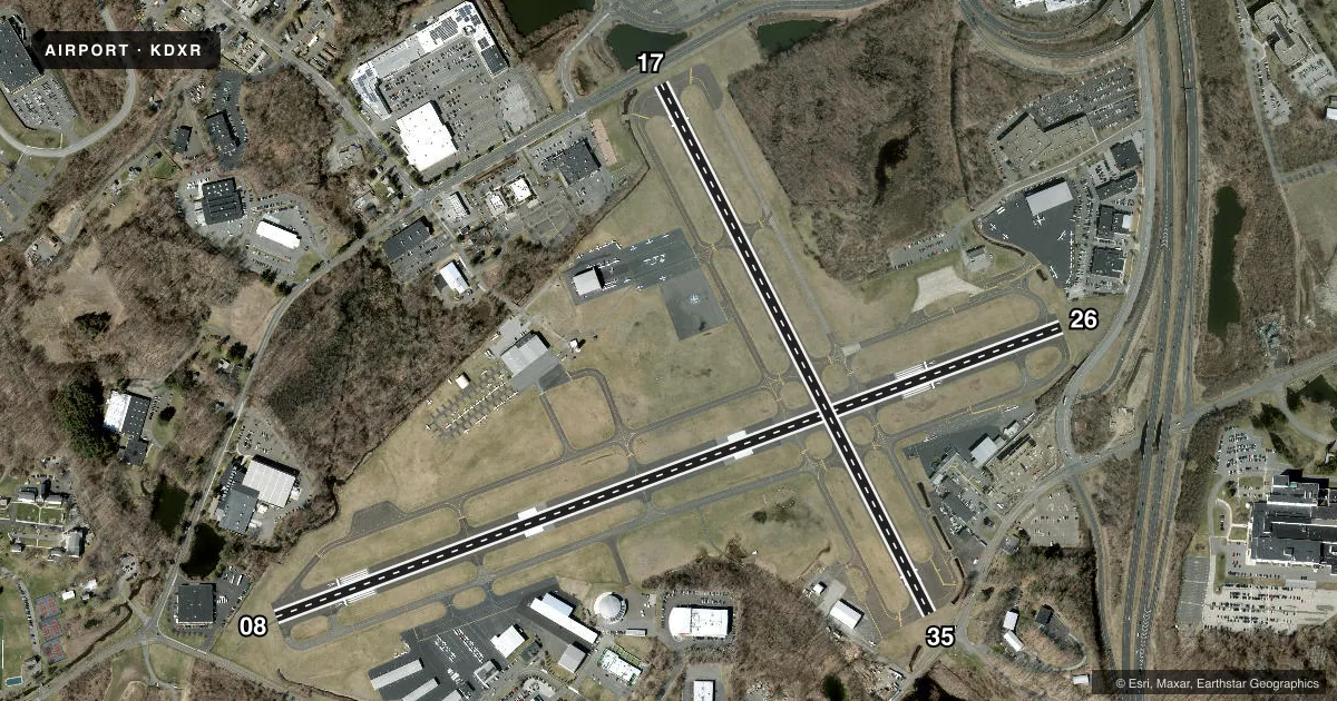
Runways & pattern
Full pagePattern entry · RWY 08
LEFT TRAFFIC| Runway | Heading (°M) | Length | Surface | Traffic |
|---|---|---|---|---|
| 08/26 | 56° / 236° | 4,421 ft | ASPH | Standard L |
| 17/35 | 139° / 319° | 3,135 ft | ASPH | Standard L |
Runway end performance
| End | TORA | TODA | ASDA | LDA | VGSI | Approach lights | Obstruction |
|---|---|---|---|---|---|---|---|
| 08 | — | — | — | — | — | — | 15', trees, 230' from thr, 75' R of cntrln, slope 2 |
| 26 | — | — | — | — | — | — | 88', trees, 450' from thr, 100' R of cntrln, slope 3 |
| 17 | — | — | — | — | — | — | 22', pole, 600' from thr, 150' R of cntrln, slope 18 |
| 35 | — | — | — | — | — | — | 30', trees, 350' from thr, 100' R of cntrln, slope 5 |
Declared distances in feet. TORA = takeoff run available, TODA = takeoff distance, ASDA = accelerate-stop, LDA = landing distance.
Airport sketch
Runways drawn to scale from FAA survey coordinates, rendered over satellite imagery. Not for navigation.
Approaches & charts
ILS · 1
Services on the field
Fuel grades, oxygen, maintenance, ramp storage and lighting — as declared to the FAA by the airport operator.
Fuel & services
- Fuel
- 100LLA
- Oxygen (bottled)
- Low pressure
- Oxygen (bulk)
- Not available
- Airframe repair
- Major
- Power plant repair
- Major
- Other services
- AFRT,AVNCS,CHTR,INSTR,RNTL,SALES,SURV
Ramp & ground
- Transient storage
- Tie-down
- Hangar
- Landing fee
- No fee published
- Customs
- Not available
- Lighting schedule
- SEE RMK
- Beacon schedule
- SS-SR
- Beacon
- White / Green (civil land)(WG)
- Wind indicator
- Lighted
- Segmented circle
- Yes
Fuel & FBOs
Cheapest 100LL and Jet A on the field and nearby. Always confirm with the FBO before taxi.
Airport notes
Surface conditions, obstructions, local procedures, lighting outages and other notes published with each FAA cycle.
General notes
- ACFT USING RWY 35 ARE NOT VSB FM TWR DESCENDING BLW 1300 FT ON BASE LEG TIL APCHG 1/2 MI FINAL DUE TO NATURAL TRRN.
- DEER & BIRDS ON & INVOF ARPT.
- INTXN TKOFS, STOP & GO TKOFS NOT AUZD.
- PPR FOR FRMN TKOF/LDG; CTC AMGR.
- NOISE ABATEMENT PROCS IN EFCT, RWY 17, SR-SS. DEPG RWY 17, EXTD RWY HDG BYD LAKE WAUBEEKA COMMUNITY BFR TURNING CROSSWIND.
- PROHIBITED TO ULTRALIGHT & UNREGISTERED ACFT.
- COND UNMNT 1630-0730 MON-FRI & WKENDS.
Lighting notes
- ROTG BCN LCTD ONE MILE SOUTH OF ARPT ON TOP OF A HILL.
- WHEN ATCT CLSD, ACTVT REIL RWY 08 & 26; MIRL RWY 08/26 - CTAF.
Runway surface & condition
- 17/35RWY CLSD NGTS.
Approach & departure obstructions
- 08+9 FT FENCE 170 FT FM THR.
- 175 FT FENCE 50 FT FM THR; +15 FT ROAD 94 FT FM THR.
- 26+6 FT FENCE 75 FT FM THR.
- 35+8 FT FENCE 150 FT FM THR; +17 FT ROAD 120 FT FM THR.
- 08APCH RATIO 12:1 BASED ON DSPLCD THR.
- 17APCH RATIO 28:1 TO DSPLCD THR.
- 26APCH RATIO 11:1 TO DSPLCD THR.
- 35APCH RATIO 19:1 TO DSPLCD THR.
Other notes
- EXISTED PRIOR TO 1959.
- 1743 FT AGL TURBOPROP/JET.
VFR map & nearby airports
VFR sectional. Tap any ICAO chip to open that airport.
Key facts · KDXR
Answer card- ICAO
- KDXR
- Name
- DANBURY MUNI
- Location
- DANBURY, CONNECTICUT
- Elevation
- 456.7 ft MSL
- Traffic pattern altitude
- 1,699.7 ft MSL (1,243 AGL)
- Control tower
- Towered · 0700-2200
- Total runways
- 2
- Longest runway
- 08/26 · 4,421 ft
- Published ILS approaches
- 1
- Published frequencies
- 8
- Magnetic variation
- 14°
- Current flight rules
- VFR
- Current wind
- 000° at 0 kt
- Favored runway now
- –
Danbury Muni sits in Danbury, Connecticut. Field elevation is 456.7 ft MSL. The airport has 2 asphalt runways. The longest is 4,421 ft on runway 08/26. The tower is open from 0700 to 2200. An ILS approach is available to runway 08. Pattern altitude is 1,699.7 ft MSL, which is 1,243 ft AGL.
This is a busy controlled field with several on-field FBOs. Executive Air Service carries 100LL and Jet A Prist. Westconn Aviation carries 100LL and Jet A. Business Aircraft Center carries 100LL, Jet A and Jet A Prist. Reliant Air carries 100LL and Jet A Prist. Exit Aviation is also on the field. Check with them directly for current services. The airport also publishes noise abatement for runway 17 from sunrise to sunset. Departing runway 17, pilots are asked to stay on runway heading beyond Lake Waubeka before turning crosswind.
There are a few operational items to keep in mind. Runway 17/35 is closed at night. Intersection takeoffs and stop-and-go takeoffs are not authorized. The published remarks also note obstructions near several runway ends, including fences close to runways 08, 17, 26 and 35. Ultralight and unregistered aircraft are prohibited. Prior permission is required for firemen takeoff and landing. For anything not covered here, check the current FAA Chart Supplement or call the airport operator before departure.