METAR & TAF KCAE
Current METAR
Observed 11:56Z
KCAE 271156Z VRB04KT 3SM BR OVC150 24/23 A2986 RMK AO2 SLP107 T02440233 10250 20233 53008 $
- Wind
- VAR @ 4 kt
- Visibility
- 3 SM
- Temp / Dew
- 24°C / 23°C
- Altimeter
- 29.86 inHg
- Clouds
- OVC
- Density alt
- 1,447 ft
- Ceiling
- 15,000 ft AGL
- Rules
- MVFR
Airport info & contacts
Manager on record, flight service, ARTCC, attendance schedule and pattern altitude — published by the FAA and refreshed every 28 days.
Location
- From city
- 5 NM SW
- VFR sectional
- CHARLOTTE
- ARTCC
- ZJX · JACKSONVILLE
- NOTAM facility
- CAE (NOTAM-D)
Airport manager
- Name
- CHRISTOPHER WHITE A.A.E
- Phone
- 803-822-5078
- Address
- 3250 AIRPORT BLVD, SUITE 10, WEST COLUMBIA SC 29170
Flight service · Hours
- FSS AND
- ANDERSON1-800-WX-BRIEF
- Attendance
- ALL
Frequencies
Tap any row to copy the frequency to your clipboard.
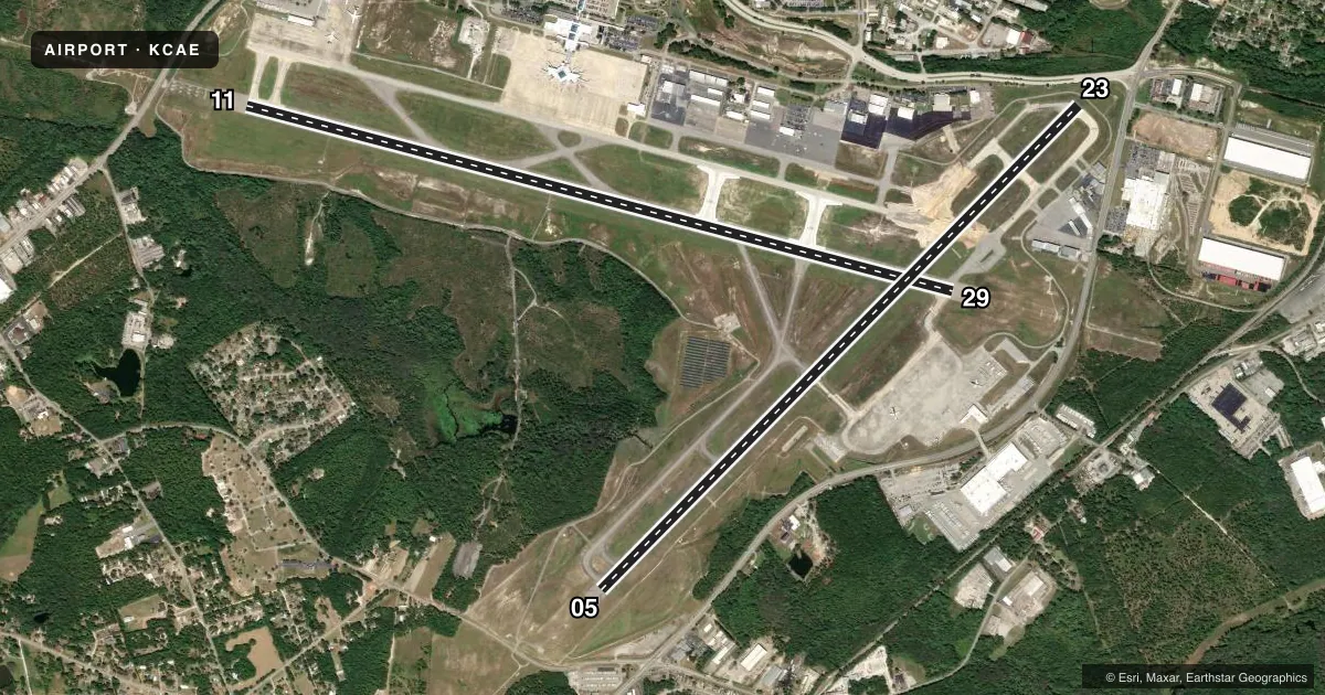
Runways & pattern
Full pagePattern entry · RWY 05
LEFT TRAFFIC| Runway | Heading (°M) | Length | Surface | Traffic |
|---|---|---|---|---|
| 11/29 | 98° / 278° | 8,601 ft | CONC | Standard L |
| 05/23Favored | 38° / 218° | 8,001 ft | ASPH-CONC | Standard L |
Runway end performance
| End | TORA | TODA | ASDA | LDA | VGSI | Approach lights | Obstruction |
|---|---|---|---|---|---|---|---|
| 11 | 8,601' | 8,601' | 8,601' | 8,601' | PAPI 4-box left(3°) | ALSF2 | — |
| 29 | 8,601' | 8,601' | 8,506' | 8,506' | PAPI 4-box left(3°) | MALSR | — |
| 05 | 8,001' | 8,001' | 7,001' | 7,001' | PAPI 4-box right(3°) | MALSR | — |
| 23 | 8,001' | 8,001' | 8,001' | 7,001' | PAPI 4-box left(3°) | — | 45', tree, 1575' from thr, 100' R of cntrln, slope 33 |
Declared distances in feet. TORA = takeoff run available, TODA = takeoff distance, ASDA = accelerate-stop, LDA = landing distance.
Airport sketch
Runways drawn to scale from FAA survey coordinates, rendered over satellite imagery. Not for navigation.
Approaches & charts
ILS · 3
Services on the field
Fuel grades, oxygen, maintenance, ramp storage and lighting — as declared to the FAA by the airport operator.
Fuel & services
- Fuel
- 100LLA
- Oxygen (bottled)
- High pressure
- Oxygen (bulk)
- High pressure
- Airframe repair
- Major
- Power plant repair
- Major
- Other services
- AFRT,AVNCS,CARGO,CHTR,INSTR,RNTL,SALES
Ramp & ground
- Transient storage
- Tie-down
- Hangar
- Landing fee
- No fee published
- Customs
- Not available
- Lighting schedule
- SS-SR
- Beacon schedule
- SS-SR
- Beacon
- White / Green (civil land)(WG)
- Wind indicator
- Lighted
- Segmented circle
- No
Fuel & FBOs
Cheapest 100LL and Jet A on the field and nearby. Always confirm with the FBO before taxi.
Airport notes
Surface conditions, obstructions, local procedures, lighting outages and other notes published with each FAA cycle.
General notes
- FEE FOR COML ACFT OVER 15000 LBS.
- OPRN OF ULTRALIGHT VEHICLES PROHIBITED.
- SPORTS COMPLEX WITH NMRS FLOOD LGTS APRXLY 6500 FT FROM APCH END RWY 11.
- NOISE ABATEMENT PROC: NO TURNS BLW 1000 FT FOR TURBINE ENG ACFT UNLESS DCTD BY ATC.
- ACFT LNDG WITH EXPLOSIVES OBTAIN PPR FM ARPT OPS 803-822-5050.
- HELIPAD H1 LOCATED NORTH OF TAXILANE E, EAST OF TWY E3.
- DUE TO PROXIMITY AND RWY ALNMT AIRCREWS HAVE MISTAKEN CUB (RWY 13/31) FOR CAE (RWY 11/29) WHICH IS 6 MILES NE.
- FOR PPR OR OTHER AFLD RELATED QUESTIONS PLEASE CALL ARPT OPS AT 803-822-5050.
Runway surface & condition
- 05/23PCR VALUE: 750/R/A/W/T
- 11/29PCR VALUE: 740/R/A/W/T
- 05/23RWY 05 200 FT BY 200 FT BLAST PAD.
- 11/29RWY 11 220 FT BY 400 FT BLAST PAD; RWY 29 220 FT BY 400 FT BLAST PAD.
Approach & departure obstructions
- 11ALSF2 ALSO OPERS AS SSALR.
Other notes
- ARPT EXISTED PRIOR TO 1958.
- OWNERARPT DIST.
- MANAGERINTERIM POCS (UNTIL KREULEN ONBOARD): FRANK MURRAY, VP PLANNING AND ENGINEERING 803-822-7817 GREGG HORNSBY, INTERIM CEO 803-822-5015
- 05/23RWY 05/23 CNTR 75 FT IS CONC, ENTIRE LEN OF RWY.
VFR map & nearby airports
VFR sectional. Tap any ICAO chip to open that airport.
Key facts · KCAE
Answer card- ICAO
- KCAE
- Name
- COLUMBIA METRO
- Location
- COLUMBIA, SOUTH CAROLINA
- Elevation
- 235.9 ft MSL
- Traffic pattern altitude
- 1,235.9 ft MSL (1,000 AGL)
- Control tower
- Towered · 24
- Total runways
- 2
- Longest runway
- 11/29 · 8,601 ft
- Published ILS approaches
- 3
- Published frequencies
- 17
- Magnetic variation
- 7°
- Current flight rules
- MVFR
- Current wind
- 000° at 4 kt
- Favored runway now
- RWY 05
Columbia Metro Airport is in Columbia, South Carolina. The field elevation is 235.9 ft MSL. It has two runways. The longest is 11/29 at 8,601 ft. Runway 05/23 is 8,001 ft. The tower is open 24 hours. Three ILS approaches are published for runway ends 05, 11 and 29.
Pattern altitude is not published. Use the standard 1,000 ft AGL for light piston traffic unless ATC or the current Chart Supplement says otherwise. That puts you at about 1,236 ft MSL based on the field elevation. The airport sits in Class C airspace. Check the current sectional or TAC if you need the exact airspace picture before arrival.
Columbia Aviation and Eagle Aviation are on the field. Both carry 100LL, Jet A and Jet A Prist. A first-time pilot should also note the noise abatement item for turbine aircraft. No turns below 1,000 ft unless ATC directs it. Runway 11 has ALSF-2 approach lighting with runway alignment indicator lights. There is also a sports complex with bright floodlights near the approach end of runway 11. The Chart Supplement notes that pilots have confused nearby CUB runway 13/31 with CAE runway 11/29. Verify your position carefully on arrival.