METAR & TAF KBMG
Current METAR
Observed 16:53Z
KBMG 271653Z 28004KT 10SM CLR 31/24 A2988 RMK AO2 SLP109 T03060244
- Wind
- 280° @ 4 kt
- Visibility
- 10 SM
- Temp / Dew
- 31°C / 24°C
- Altimeter
- 29.88 inHg
- Clouds
- CLR
- Density alt
- 3,018 ft
- Ceiling
- Unlimited
- Rules
- VFR
Airport info & contacts
Manager on record, flight service, ARTCC, attendance schedule and pattern altitude — published by the FAA and refreshed every 28 days.
Location
- From city
- 4 NM SW
- VFR sectional
- ST LOUIS
- ARTCC
- ZID · INDIANAPOLIS
- NOTAM facility
- BMG (NOTAM-D)
Airport manager
- Name
- CARLOS LAVERTY
- Phone
- 812-825-5406
- Address
- 972 S. KIRBY RD, BLOOMINGTON IN 47403
Flight service · Hours
- FSS HUF
- TERRE HAUTE1-800-WX-BRIEF
- Attendance
- 0630-2130
Frequencies
Tap any row to copy the frequency to your clipboard.
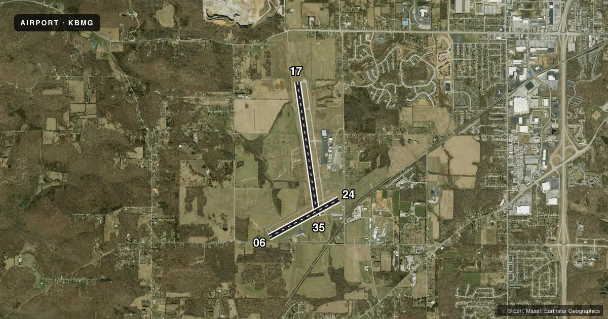
Runways & pattern
Full pagePattern entry · RWY 24
LEFT TRAFFIC| Runway | Heading (°M) | Length | Surface | Traffic |
|---|---|---|---|---|
| 17/35 | 170° / 350° | 6,500 ft | ASPH | Standard L |
| 06/24Favored | 60° / 240° | 3,798 ft | ASPH | Standard L |
Runway end performance
| End | TORA | TODA | ASDA | LDA | VGSI | Approach lights | Obstruction |
|---|---|---|---|---|---|---|---|
| 17 | — | — | — | — | PAPI 4-box left(3°) | — | 60', tree, 2600' from thr, 1100' R of cntrln, slope 40 |
| 35 | — | — | — | — | — | MALSR | — |
| 06 | — | — | — | — | — | — | 22', road, 200' from thr, 204' R of cntrln, slope 0 |
| 24 | — | — | — | — | PAPI 4-box left(4°) | — | 18', road, 200' from thr, 100' R of cntrln, slope 0 |
Declared distances in feet. TORA = takeoff run available, TODA = takeoff distance, ASDA = accelerate-stop, LDA = landing distance.
Airport sketch
Runways drawn to scale from FAA survey coordinates, rendered over satellite imagery. Not for navigation.
Approaches & charts
ILS · 1
Services on the field
Fuel grades, oxygen, maintenance, ramp storage and lighting — as declared to the FAA by the airport operator.
Fuel & services
- Fuel
- 100LLA
- Oxygen (bottled)
- HIGH/LOW
- Airframe repair
- Major
- Power plant repair
- Major
- Other services
- CHTR,INSTR,RNTL
Ramp & ground
- Transient storage
- Tie-down
- Hangar
- Landing fee
- No fee published
- Customs
- Not available
- Lighting schedule
- SEE RMK
- Beacon schedule
- SS-SR
- Beacon
- White / Green (civil land)(WG)
- Wind indicator
- Lighted
- Segmented circle
- Yes
Fuel & FBOs
Cheapest 100LL and Jet A on the field and nearby. Always confirm with the FBO before taxi.
Airport notes
Surface conditions, obstructions, local procedures, lighting outages and other notes published with each FAA cycle.
General notes
- SFC COND UNMNT MON-FRI 1600-0800 & WKEND.
- FOR CD CTC HULMAN APCH AT 812-877-7581.
Lighting notes
- WHEN ATCT CLSD ACTVT MALSR RWY 35; REIL RWY 17; PAPI RWY 24; MIRL RWY 06/24; HIRL RWY 17/35 - CTAF. PAPI RWY 17 ON CONSLY.
Runway surface & condition
- 17/35PCR VALUE: 568/F/C/X/T
- 06/24RWY 06/24 NOT AVBL FOR PART 121/PART 380 OPS WITH SKED PAX CARRYING OPS MORE THAN 9 PAX SEATS AND NON-SKED PAX CARRYING OPS MORE THAN 30 PAX SEATS. AVBL ACR TAX ONLY.
Approach & departure obstructions
- 06ROAD 100-200 FT FM THR 200-250 FT R.
- 247 FT FENCE 175 FT FM THR 113 FT L OF RWY EXTDD CTRLN.
- 06APCH RATIO 19:1 TO DTHR; 64 FT TREES 950 FT FM RWY 210 FT R.
- 24APCH RATIO 12:1; 19 FT ROAD 245 FT FM DTHR 250 FT L.
Other notes
- CLSD TO SKED ACR OPS GTR THAN 9 PAX SEATS. UNSKED ACR OPS GTR THAN 30 PAX SEATS PPR - OPS MGR 812-825-5406 OR 812-606-6659 AT NIGHT OR ON WKEND & HOL. INDEX B ARFF CAPABILITY AVBL ON REQ.
VFR map & nearby airports
VFR sectional. Tap any ICAO chip to open that airport.
Key facts · KBMG
Answer card- ICAO
- KBMG
- Name
- MONROE COUNTY
- Location
- BLOOMINGTON, INDIANA
- Elevation
- 845.5 ft MSL
- Traffic pattern altitude
- 1,845.5 ft MSL (1,000 AGL)
- Control tower
- Towered · 0630-2130
- Total runways
- 2
- Longest runway
- 17/35 · 6,500 ft
- Published ILS approaches
- 1
- Published frequencies
- 7
- Magnetic variation
- 2°
- Current flight rules
- VFR
- Current wind
- 280° at 4 kt
- Favored runway now
- RWY 24
Monroe County Airport sits in Bloomington, Indiana. Field elevation is 845.5 ft MSL. The airport has two asphalt runways. The longest is runway 17/35 at 6,500 ft. The control tower is open daily from 0630 to 2130. There is 1 ILS approach. It serves runway 35.
Pattern altitude is not published. Use 1,000 ft AGL for light piston operations unless the current Chart Supplement says otherwise. On the field, BMG Jet Center carries 100LL, Jet A and Jet A Prist. Cook Aviation carries 100LL and Jet A Prist. If you need current ramp or fuel details, call the FBO directly before arrival.
This is a busy controlled field for the Bloomington area. Runway 06 has nearby trees and a road off the departure end. Runway 24 has a fence near the threshold and a road near the approach path. Runway 06/24 is also restricted for some passenger-carrying operations. When the tower is closed, lighting is activated by CTAF. Check the current Chart Supplement for any published noise or curfew restrictions before flying into the field. For clearance delivery, contact Hulman Approach. If you are planning a first trip, brief the runway 35 ILS, the tower hours and the runway 17/35 pavement strength before you go.