METAR & TAF KWVI
Current METAR
Observed 17:53Z
KWVI 271753Z AUTO 21005KT 10SM CLR 19/13 A3005 RMK AO2 SLP174 T01940133 10194 20122 56004
- Wind
- 210° @ 5 kt
- Visibility
- 10 SM
- Temp / Dew
- 19°C / 13°C
- Altimeter
- 30.05 inHg
- Clouds
- CLR
- Density alt
- 521 ft
- Ceiling
- Unlimited
- Rules
- VFR
Airport info & contacts
Manager on record, flight service, ARTCC, attendance schedule and pattern altitude — published by the FAA and refreshed every 28 days.
Location
- From city
- 3 NM NW
- VFR sectional
- SAN FRANCISCO
- ARTCC
- ZOA · OAKLAND
- NOTAM facility
- WVI (NOTAM-D)
Airport manager
- Name
- RAYVON WILLIAMS
- Phone
- 831-768-3575
- Address
- 100 AVIATION WAY, WATSONVILLE CA 95076
Flight service · Hours
- FSS OAK
- OAKLAND1-800-WX-BRIEF
- Attendance
- 0900-1700
Frequencies
Tap any row to copy the frequency to your clipboard.
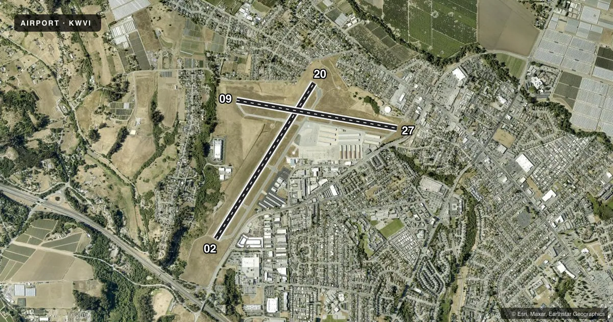
Runways & pattern
Full pagePattern entry · RWY 20
LEFT TRAFFIC| Runway | Heading (°M) | Length | Surface | Traffic |
|---|---|---|---|---|
| 02/20Favored | 18° / 198° | 4,502 ft | ASPH | Standard L |
| 09/27 | 86° / 266° | 3,998 ft | ASPH | Standard L |
Runway end performance
| End | TORA | TODA | ASDA | LDA | VGSI | Approach lights | Obstruction |
|---|---|---|---|---|---|---|---|
| 02 | — | — | — | — | PAPI 2-box left(3°) | — | 46', trees, 1310' from thr, 39' R of cntrln, slope 24 |
| 20 | — | — | — | — | PAPI 2-box left(3°) | — | 80', tree, 1198' from thr, 125' R of cntrln, slope 12 |
| 09 | — | — | — | — | PAPI 2-box right(4°) | — | 38', tree, 1050' from thr, 0' R of cntrln, slope 22 |
| 27 | — | — | — | — | — | — | 55', tree, 935' from thr, 40' R of cntrln, slope 13 |
Declared distances in feet. TORA = takeoff run available, TODA = takeoff distance, ASDA = accelerate-stop, LDA = landing distance.
Airport sketch
Runways drawn to scale from FAA survey coordinates, rendered over satellite imagery. Not for navigation.
Approaches & charts
ILS · 1
Services on the field
Fuel grades, oxygen, maintenance, ramp storage and lighting — as declared to the FAA by the airport operator.
Fuel & services
- Fuel
- 100LLAG100UL
- Oxygen (bottled)
- Low pressure
- Oxygen (bulk)
- Not available
- Airframe repair
- Minor
- Power plant repair
- Major
- Other services
- AVNCS,CHTR,INSTR,PAJA,RNTL,SALES,SURV
Ramp & ground
- Transient storage
- Tie-down
- Landing fee
- No fee published
- Customs
- Not available
- Lighting schedule
- SEE RMK
- Beacon schedule
- SS-SR
- Beacon
- White / Green (civil land)(WG)
- Wind indicator
- Lighted
- Segmented circle
- Yes
Fuel & FBOs
Cheapest 100LL and Jet A on the field and nearby. Always confirm with the FBO before taxi.
Airport notes
Surface conditions, obstructions, local procedures, lighting outages and other notes published with each FAA cycle.
General notes
- SEAGULLS ON & INVOF ARPT.
- ARPT HAS NOISE ABATEMENT PROCS; SEE ARPT WEBSITE.
- RWY 20 PREF CALM WIND RWY; STRAIGHT-IN APCH NOT RCMDD.
- GLIDER TOWING RQRS PRIOR NOTIFICATION, CTC ARPT OFC 831-768-3575.
- HELICOPTER ACTVTY ON AND INVOF ARPT.
- COASTAL FOG DURING SUMMER MONTHS.
- PRCHT OPS ON ARPT DLY 0900-2000; LNDG AREA 1000 FT WEST OF RWY 20.
- FOR CD CTC NORCAL APCH AT 916-361-3748 OR VIA VHF 127.15.
- ALL DEPS PROHIBITED ON RWY 27 DUE TO RWY VIS BLOCKED BY HNGRS.
- 130 FT TREES 700 FT RIGHT OF RWY 9 THLD, 85 FT TREES 600 FT LEFT OF RWY 9 THLD.
Lighting notes
- ACTVT PAPI RWY 02, 09 & 20; REIL RWY 02; MIRL RWY 02/20 - CTAF.
Approach & departure obstructions
- 20UNUSBL BYD 4.0 NM DUE TO TERRAIN.
- 20RWY 20 APCH RATIO 22:1 TO DSPLCD THR.
Other notes
- MANAGERRAYVON.WILLIAMS@CITYOFWATSONVILLE.ORG
VFR map & nearby airports
VFR sectional. Tap any ICAO chip to open that airport.
Key facts · KWVI
Answer card- ICAO
- KWVI
- Name
- WATSONVILLE MUNI
- Location
- WATSONVILLE, CALIFORNIA
- Elevation
- 163.3 ft MSL
- Traffic pattern altitude
- 1,163.3 ft MSL (1,000 AGL)
- Control tower
- Non-towered (use CTAF)
- Total runways
- 2
- Longest runway
- 02/20 · 4,502 ft
- Published ILS approaches
- 1
- Published frequencies
- 6
- Magnetic variation
- 14°
- Current flight rules
- VFR
- Current wind
- 210° at 5 kt
- Favored runway now
- RWY 20
Watsonville Muni sits in Watsonville, California at 163.3 ft MSL. It has two asphalt runways. The longest is runway 02/20 at 4,502 ft. The field is non-towered. Pattern altitude is not published, so use standard 1,000 ft AGL for light piston traffic unless the current Chart Supplement says otherwise.
The airport has one ILS approach to runway 02. Published remarks matter here. Runway 27 departures are prohibited because hangars block runway visibility. Runway 20 is the preferred calm-wind runway. Straight-in approaches are not recommended there. Coastal fog can show up in summer. Seagulls are also a factor on and near the field. Trees near runway 9 are another thing to watch. There are 130-foot trees 700 feet right of the runway 9 threshold. There are also 85-foot trees 600 feet left of that threshold.
Watsonville Municipal Airport is the on-field FBO. It carries 100LL, Jet A and Jet A Prist. If you need clearance delivery, NorCal Approach is listed on 127.15. The airport also has noise abatement procedures. Check the current Chart Supplement or the airport operator before you go if you need the latest local procedure details.