METAR & TAF KWDG
Current METAR
Observed 16:50Z
KWDG 271650Z 12008KT 10SM CLR 36/20 A2987
- Wind
- 120° @ 8 kt
- Visibility
- 10 SM
- Temp / Dew
- 36°C / 20°C
- Altimeter
- 29.87 inHg
- Clouds
- CLR
- Density alt
- 4,029 ft
- Ceiling
- Unlimited
- Rules
- VFR
Airport info & contacts
Manager on record, flight service, ARTCC, attendance schedule and pattern altitude — published by the FAA and refreshed every 28 days.
Location
- From city
- 4 NM SE
- VFR sectional
- WICHITA
- ARTCC
- ZKC · KANSAS CITY
- NOTAM facility
- WDG (NOTAM-D)
Airport manager
- Name
- KESTON COOK
- Phone
- 580-616-7386
- Address
- 1026 SOUTH 66TH STREET, ENID OK 73701
Flight service · Hours
- FSS MLC
- MC ALESTER1-800-WX-BRIEF
- Attendance
- 0600-2130
Frequencies
Tap any row to copy the frequency to your clipboard.
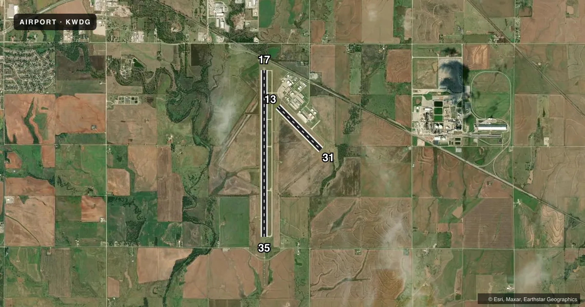
Runways & pattern
Full pagePattern entry · RWY 13
LEFT TRAFFIC| Runway | Heading (°M) | Length | Surface | Traffic |
|---|---|---|---|---|
| 17/35 | 175° / 355° | 8,613 ft | CONC | 35 R |
| 13/31Favored | 130° / 310° | 3,150 ft | CONC | 31 R |
Runway end performance
| End | TORA | TODA | ASDA | LDA | VGSI | Approach lights | Obstruction |
|---|---|---|---|---|---|---|---|
| 17 | 8,613' | 8,613' | 8,613' | 8,002' | PAPI 4-box left(3°) | — | 20', road, 284' from thr, 512' R of cntrln, slope 4 |
| 35 | 8,002' | 8,002' | 8,002' | 8,002' | PAPI 4-box left(3°) | MALSR | — |
| 13 | 3,150' | 3,150' | 3,150' | 3,038' | PAPI 2-box left(3°) | — | — |
| 31 | 3,150' | 3,150' | 3,038' | 3,038' | PAPI 2-box left(3°) | — | — |
Declared distances in feet. TORA = takeoff run available, TODA = takeoff distance, ASDA = accelerate-stop, LDA = landing distance.
Airport sketch
Runways drawn to scale from FAA survey coordinates, rendered over satellite imagery. Not for navigation.
Approaches & charts
ILS · 1
Services on the field
Fuel grades, oxygen, maintenance, ramp storage and lighting — as declared to the FAA by the airport operator.
Fuel & services
- Fuel
- 100LLA+
- Oxygen (bottled)
- Not available
- Oxygen (bulk)
- HIGH/LOW
- Airframe repair
- Minor
- Power plant repair
- Minor
- Other services
- AFRT,INSTR,RNTL
Ramp & ground
- Transient storage
- Tie-down
- Hangar
- Landing fee
- No fee published
- Customs
- Not available
- Lighting schedule
- SEE RMK
- Beacon schedule
- SS-SR
- Beacon
- White / Green (civil land)(WG)
- Wind indicator
- Lighted
- Segmented circle
- Yes
Fuel & FBOs
Cheapest 100LL and Jet A on the field and nearby. Always confirm with the FBO before taxi.
Airport notes
Surface conditions, obstructions, local procedures, lighting outages and other notes published with each FAA cycle.
General notes
- MIL JET TRNG DRG DALGT HRS INVOF ARPT.
- NOISE SENSITIVE AREA 3/4NM NW. ALL ACFT DEP RWY 35 CLIMB 500FT AGL PRIOR TO TURNING CROSSWIND TO WEST.
- FOR CD CTC VANCE APCH C580-213-6765. WHEN VANCE APCH CLSD, CTC KANSAS CITY ARTCC 913-254-8508.
Lighting notes
- WHEN ATCT CLSD ACTVT MALSR RWY 35; REIL RWY 17; MIRL RWY 17/35 & 13/31 - CTAF. PAPI RWY 17 & 35, 13 & 31 OPER CONSLY.
Fuel notes
- 100LLFUEL AVBL 24 HRS. SELF SVC AVGAS AVBL. FOR JET A FUEL AFT HRS CALL(580) 231-0189.
Approach & departure obstructions
- 17OBSTN CLC SLOPE 44:1 TO DISP THLD.
Other notes
- 2100 LBS
VFR map & nearby airports
VFR sectional. Tap any ICAO chip to open that airport.
Key facts · KWDG
Answer card- ICAO
- KWDG
- Name
- ENID WOODRING RGNL
- Location
- ENID, OKLAHOMA
- Elevation
- 1,167.2 ft MSL
- Traffic pattern altitude
- 2,167.2 ft MSL (1,000 AGL)
- Control tower
- Towered · 0630-2100
- Total runways
- 2
- Longest runway
- 17/35 · 8,613 ft
- Published ILS approaches
- 1
- Published frequencies
- 7
- Magnetic variation
- 5°
- Current flight rules
- VFR
- Current wind
- 120° at 8 kt
- Favored runway now
- RWY 13
Enid Woodring Regional Airport is in Enid, Oklahoma. Field elevation is 1,167.2 ft MSL. The airport has two concrete runways. The longest is runway 17/35 at 8,613 ft. Tower service runs from 0630 to 2100. One ILS approach is available to runway 35. Pattern altitude is not published in the facts, so use the standard 1,000 ft AGL for light piston unless the current Chart Supplement says otherwise.
The on-field FBO is Enid Woodring Regional Airport. It carries 100LL and Jet A Prist. Self-serve avgas is available 24 hours. That is useful here if you are planning an early or late stop. For Jet A after hours, call ahead before you launch.
There are a few operational points to keep in mind. A noise sensitive area sits three quarters of a nautical mile northwest of the field. Departures from runway 35 must climb to 500 ft AGL before turning crosswind to the west. Military jet training also occurs in the area during daylight hours. When the tower is closed, lighting is activated on CTAF. PAPI stays on continuously for both runway pairs. Check the current Chart Supplement for any changes before you go.