METAR & TAF KUAO
Current METAR
Observed 09:53Z
KUAO 270953Z AUTO 00000KT 10SM CLR 13/11 A3009 RMK AO2 SLP188 T01330111
- Wind
- 000° @ 0 kt
- Visibility
- 10 SM
- Temp / Dew
- 13°C / 11°C
- Altimeter
- 30.09 inHg
- Clouds
- CLR
- Density alt
- -203 ft
- Ceiling
- Unlimited
- Rules
- VFR
Airport info & contacts
Manager on record, flight service, ARTCC, attendance schedule and pattern altitude — published by the FAA and refreshed every 28 days.
Location
- From city
- 1 NM NW
- VFR sectional
- SEATTLE
- ARTCC
- ZSE · SEATTLE
- NOTAM facility
- UAO (NOTAM-D)
Airport manager
- Name
- ANTHONY BEACH
- Phone
- 503-378-4880
- Address
- 3040 25TH ST SE, SALEM OR 97302-1125
Flight service · Hours
- FSS MMV
- MC MINNVILLE1-800-WX-BRIEF
- Attendance
- 0700-2000
Frequencies
Tap any row to copy the frequency to your clipboard.
Runways & pattern
Full pagePattern entry · RWY 17
LEFT TRAFFICRunway end performance
| End | TORA | TODA | ASDA | LDA | VGSI | Approach lights | Obstruction |
|---|---|---|---|---|---|---|---|
| 17 | — | — | — | — | VASI 4-box right(3.5°) | ODALS | 100', trees, 2939' from thr, 175' R of cntrln, slope 27 |
| 35 | — | — | — | — | VASI 4-box left(3.25°) | — | 90', tree, 1634' from thr, 520' R of cntrln, slope 16 |
Declared distances in feet. TORA = takeoff run available, TODA = takeoff distance, ASDA = accelerate-stop, LDA = landing distance.
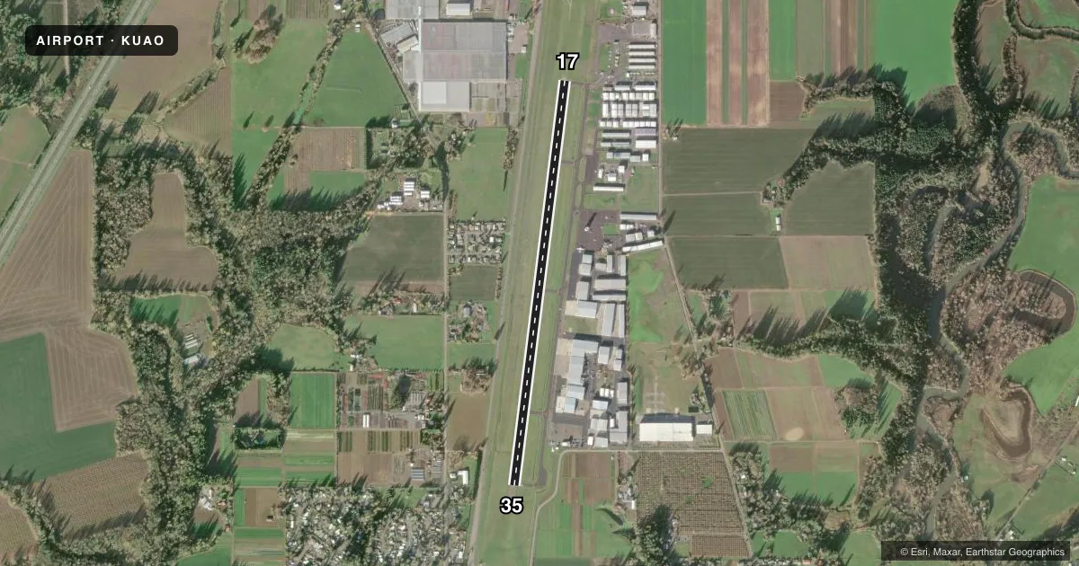
Airport sketch
Runways drawn to scale from FAA survey coordinates, rendered over satellite imagery. Not for navigation.
Approaches & charts
ILS · 1
Services on the field
Fuel grades, oxygen, maintenance, ramp storage and lighting — as declared to the FAA by the airport operator.
Fuel & services
- Fuel
- 100LLA
- Oxygen (bottled)
- Not available
- Oxygen (bulk)
- High pressure
- Airframe repair
- Major
- Power plant repair
- Major
- Other services
- AMB,AVNCS,CHTR,INSTR,RNTL,SALES
Ramp & ground
- Transient storage
- Tie-down
- Landing fee
- No fee published
- Customs
- Not available
- Lighting schedule
- SEE RMK
- Beacon schedule
- SS-SR
- Beacon
- White / Green (civil land)(WG)
- Wind indicator
- Lighted
- Segmented circle
- Yes
Fuel & FBOs
Cheapest 100LL and Jet A on the field and nearby. Always confirm with the FBO before taxi.
Airport notes
Surface conditions, obstructions, local procedures, lighting outages and other notes published with each FAA cycle.
General notes
- RY 35 CALM WIND RY. USE ONLY PAVED SFCS. FREQUENT STRAIGHT IN INSTRUMENT APCH TFC TO RY 17.
- RY 17 +30 FT PLINE 2100 FT FM THLD; MKD BY BALLS.
- PARALLEL TWY 35 FT WIDE AND HAS MEDIUM INTENSITY TWY LGTS.
- MIGRATORY BIRDS, COYOTES, AND DEER ON AND INVOF ARPT.
- NOISE ABATEMENT SENS AREA: 2 MI N OF RWY 17; 1 MI SE OF RWY 35; HLF MI SW OF RWY 35. AVOID LOW LEVEL OVER-FLIGHTS OF RESIDENTIAL AREAS SRNDG ARPT WHENEVER POSS.
- ALL TAXILANES NON STD WINGTIP CLNC.
- OVERWEIGHT ACFT CTC OWNER PRIOR 503-378-4880
Lighting notes
- ACTVT MIRL RY 17/35, VASI RYS 17 & 35 AND ODALS RY 17 - CTAF.
Runway surface & condition
- 17/35RY 17/35 150 FT BLAST PAD AT SOUTH END.
Other notes
- MANAGERANTHONY.BEACH@ODAV.OREGON.GOV
VFR map & nearby airports
VFR sectional. Tap any ICAO chip to open that airport.
Key facts · KUAO
Answer card- ICAO
- KUAO
- Name
- AURORA STATE
- Location
- AURORA, OREGON
- Elevation
- 199.6 ft MSL
- Traffic pattern altitude
- 1,199.6 ft MSL (1,000 AGL)
- Control tower
- Towered · 0700-2000
- Total runways
- 1
- Longest runway
- 17/35 · 5,003 ft
- Published ILS approaches
- 1
- Published frequencies
- 10
- Magnetic variation
- 15°
- Current flight rules
- VFR
- Current wind
- 000° at 0 kt
- Favored runway now
- –
Aurora State Airport sits in Aurora, Oregon. The field elevation is 199.6 ft MSL. It has one runway. Runway 17/35 is 5,003 ft long and paved with asphalt. The tower is open daily from 0700 to 2000. One ILS approach is published for runway 17. Pattern altitude is not published in the facts, so use the current Chart Supplement before you fly. For light piston traffic, the standard 1,000 ft AGL pattern is a common starting point. Verify the published pattern and local procedure before arrival.
Atlantic Aviation is on the field. It carries 100LL and Jet A. The airport sits in a busy part of the Portland area, so expect frequent straight-in instrument traffic to runway 17. Noise abatement procedures are in effect. The sensitive areas are north of runway 17, southeast of runway 35 and southwest of runway 35. Avoid low overflights over nearby residential areas whenever practical. Runway 35 is the calm wind runway. Medium intensity runway lights are available. VASI is available for both runway ends. The airport also has an omnidirectional approach lighting system for runway 17. Watch for birds, coyotes and deer near the field. Runway 17 has a power line about 2,100 ft from the threshold. It is marked by balls.