METAR & TAF KTTD
Current METAR
Observed 10:53Z
KTTD 271053Z AUTO 00000KT 10SM CLR 13/13 A3008 RMK AO2 SLP186 T01330128
- Wind
- 000° @ 0 kt
- Visibility
- 10 SM
- Temp / Dew
- 13°C / 13°C
- Altimeter
- 30.08 inHg
- Clouds
- CLR
- Density alt
- -390 ft
- Ceiling
- Unlimited
- Rules
- VFR
Airport info & contacts
Manager on record, flight service, ARTCC, attendance schedule and pattern altitude — published by the FAA and refreshed every 28 days.
Location
- From city
- 10 NM E
- VFR sectional
- SEATTLE
- ARTCC
- ZSE · SEATTLE
- NOTAM facility
- TTD (NOTAM-D)
Airport manager
- Name
- KAMA SIMONDS
- Phone
- 503-415-6119
- Address
- PORT OF PORTLAND BOX 3529, PORTLAND OR 97208
Flight service · Hours
- FSS MMV
- MC MINNVILLE1-800-WX-BRIEF
- Attendance
- 0700-2200
Frequencies
Tap any row to copy the frequency to your clipboard.
Runways & pattern
Full pagePattern entry · RWY 07
LEFT TRAFFICRunway end performance
| End | TORA | TODA | ASDA | LDA | VGSI | Approach lights | Obstruction |
|---|---|---|---|---|---|---|---|
| 07 | — | — | — | — | VASI 4-box left(3°) | — | 105', trees, 2100' from thr, 0' R of cntrln, slope 18 |
| 25 | 5,399' | 5,399' | 5,399' | 5,046' | PAPI 4-box left(3.1°) | — | 63', trees, 1653' from thr, 0' R of cntrln, slope 23 |
Declared distances in feet. TORA = takeoff run available, TODA = takeoff distance, ASDA = accelerate-stop, LDA = landing distance.
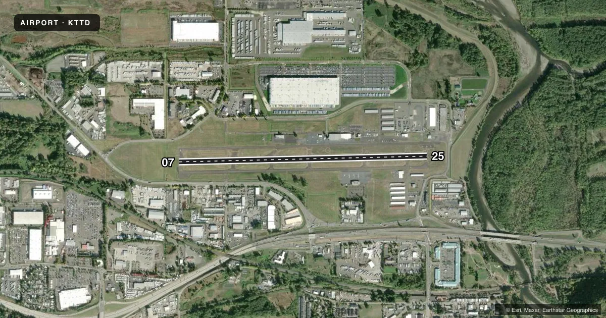
Airport sketch
Runways drawn to scale from FAA survey coordinates, rendered over satellite imagery. Not for navigation.
Approaches & charts
Services on the field
Fuel grades, oxygen, maintenance, ramp storage and lighting — as declared to the FAA by the airport operator.
Fuel & services
- Fuel
- 100LLA
- Oxygen (bottled)
- Not available
- Oxygen (bulk)
- High pressure
- Airframe repair
- Major
- Power plant repair
- Major
- Other services
- AVNCS,CHTR,INSTR,RNTL,SALES
Ramp & ground
- Transient storage
- Tie-down
- Hangar
- Landing fee
- Yes
- Customs
- Not available
- Lighting schedule
- SEE RMK
- Beacon schedule
- SS-SR
- Beacon
- White / Green (civil land)(WG)
- Wind indicator
- Lighted
- Segmented circle
- Yes
Fuel & FBOs
Cheapest 100LL and Jet A on the field and nearby. Always confirm with the FBO before taxi.
Airport notes
Surface conditions, obstructions, local procedures, lighting outages and other notes published with each FAA cycle.
General notes
- MIGRATORY FLOCKSOF WATERFOWL ON & INVOF ARPT.
- PORTLAND INTL ARPT RY 10L/28R EXTNDD CENTERLINE CROSSES ARPT, ATCT MAY ISSUE RESTRICCTIONS DUE TO PDX TFC.
- NOISE ABATEMENT PROCEDURES IN EFFECT. CALL 503-460-4100 OR 800-938-6647.
- NOISE SENSITIVE AREAS BORDER THE ARPT WEST AND SOUTH.
- AVOID LOW-LEVEL OVERFLIGHTS OF RESIDENTIAL AREAS.
- RECOMMEND BETWEEN SS AND SR, RY 7 LEFT TFC AND RY 25 RIGHT TFC DUE TO BLUFF 5000 FT SOUTH OF ARPT.
- EXTENSIVE HELICOPTER OPS ON AND ADJACENT TO WEST ENDS OF THE PARALLEL TWYS, NO EARLY TURNOUTS.
- MULTIPLE CONST CRANES 110 FT AGL OR BLO LOCATED 2700 FT SW OF RY 25 THLD.
- FOR CD CTC PORTLAND APCH AT 503-493-7545.
Lighting notes
- ACTVT MIRL RY 07/25 - CTAF. RY 07 VASI & RY 25 PAPI OPER CONT.
Approach & departure obstructions
- 25RY 25 PAPI IS BAFFLED 08 DEG L AND R OF CNTRLN.
- 07APCH CLNC SLOPE FROM DTHR IS 45:1 BASED ON 21' ROAD AT 817'.
- 25APCH RATIO 27:1; DIKE AT 588' LGTD.
Other notes
- ESTABD PRIOR TO 1959.
- COMMERCIAL ACFT & OPERATORS OF ACFT WITH AN FAA CERTIFIED MAX GROSS LANDING WEIGHT THAT EXCEEDS 10000 LBS ARE REQUIRED TO PAY A LANDING FEE.
VFR map & nearby airports
VFR sectional. Tap any ICAO chip to open that airport.
Key facts · KTTD
Answer card- ICAO
- KTTD
- Name
- PORTLAND-TROUTDALE
- Location
- PORTLAND, OREGON
- Elevation
- 38.9 ft MSL
- Traffic pattern altitude
- 1,038.9 ft MSL (1,000 AGL)
- Control tower
- Towered · 0700-2200
- Total runways
- 1
- Longest runway
- 07/25 · 5,399 ft
- Published ILS approaches
- 0
- Published frequencies
- 11
- Magnetic variation
- 16°
- Current flight rules
- VFR
- Current wind
- 000° at 0 kt
- Favored runway now
- –
Portland-Troutdale Airport sits in Portland, Oregon. Field elevation is 38.9 ft MSL. The airport has one runway, 07/25, at 5,399 ft. The tower is open 0700 to 2200. No ILS approaches are published here, so plan with the current charted procedures and weather minimums in mind.
For pattern work, the published pattern altitude is not given. Use standard 1,000 ft AGL for light piston operations unless the current Chart Supplement says otherwise. Gorge Winds Aviation is on the field. It carries 100LL, Jet A and Jet A Prist. Call the FBO directly for current service details before you go.
This is a busy airport. Published remarks call out heavy helicopter activity near the west ends of the parallel taxiways. They also note construction cranes southwest of runway 25, waterfowl in the area and noise abatement procedures in effect. At night, the remarks recommend left traffic for runway 7 and right traffic for runway 25 because of the bluff south of the airport. Runway 25 also has a published PAPI note. If you need clearance delivery, contact Portland Approach. Check the current Chart Supplement before departure for any updated operational notes.