METAR & TAF KTFP
Current METAR
Observed 13:35Z
KTFP 271335Z AUTO 20008KT 10SM SCT020 29/26 A2997 RMK AO1 T02910256
- Wind
- 200° @ 8 kt
- Visibility
- 10 SM
- Temp / Dew
- 29°C / 26°C
- Altimeter
- 29.97 inHg
- Clouds
- SCT
- Density alt
- 1,640 ft
- Ceiling
- Unlimited
- Rules
- VFR
Airport info & contacts
Manager on record, flight service, ARTCC, attendance schedule and pattern altitude — published by the FAA and refreshed every 28 days.
Location
- From city
- 2 NM N
- VFR sectional
- BROWNSVILLE
- ARTCC
- ZHU · HOUSTON
- NOTAM facility
- SJT (NOTAM-D)
Airport manager
- Name
- GARY LEE DAVIS
- Phone
- 361-226-0112
- Address
- 3141 FM 3512, ARANSAS PASS TX 78336
Flight service · Hours
- FSS SJT
- SAN ANGELO1-800-WX-BRIEF
- Attendance
- MON-FRI · 0800-1630
- SAT-SUN · 0800-1600
Frequencies
Tap any row to copy the frequency to your clipboard.
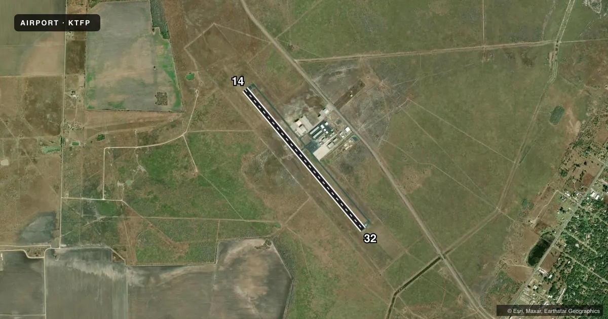
Runways & pattern
Full pagePattern entry · RWY 14
LEFT TRAFFICRunway end performance
| End | TORA | TODA | ASDA | LDA | VGSI | Approach lights | Obstruction |
|---|---|---|---|---|---|---|---|
| 14 | — | — | — | — | PAPI 2-box left(3°) | — | — |
| 32 | — | — | — | — | PAPI 2-box left(3°) | — | — |
Declared distances in feet. TORA = takeoff run available, TODA = takeoff distance, ASDA = accelerate-stop, LDA = landing distance.
Airport sketch
Runways drawn to scale from FAA survey coordinates, rendered over satellite imagery. Not for navigation.
Approaches & charts
Services on the field
Fuel grades, oxygen, maintenance, ramp storage and lighting — as declared to the FAA by the airport operator.
Fuel & services
- Fuel
- 100LLA+
- Airframe repair
- Major
- Power plant repair
- Major
- Other services
- INSTR
Ramp & ground
- Transient storage
- Tie-down
- Hangar
- Lighting schedule
- SEE RMK
- Beacon schedule
- SS-SR
- Beacon
- White / Green (civil land)(WG)
- Wind indicator
- Lighted
- Segmented circle
- Yes
Fuel & FBOs
Cheapest 100LL and Jet A on the field and nearby. Always confirm with the FBO before taxi.
Airport notes
Surface conditions, obstructions, local procedures, lighting outages and other notes published with each FAA cycle.
General notes
- FOR CD CTC CORPUS CHRISTI APCH AT 361-299-4230.
Lighting notes
- MIRL RWY 14/32 PRESET LOW INTST; TO INCR INTST ACTVT - CTAF.
Fuel notes
- 100LLFUEL: FULL SERV & SELF SERVE.
Approach & departure obstructions
- 14NORTH END OF RWY CNTRLN MKG POOR.
Other notes
- MANAGER317-410-0724
VFR map & nearby airports
VFR sectional. Tap any ICAO chip to open that airport.
Key facts · KTFP
Answer card- ICAO
- KTFP
- Name
- INGLESIDE RGNL
- Location
- INGLESIDE, TEXAS
- Elevation
- 17.7 ft MSL
- Traffic pattern altitude
- 1,017.7 ft MSL (1,000 AGL)
- Control tower
- Non-towered (use CTAF)
- Total runways
- 1
- Longest runway
- 14/32 · 4,999 ft
- Published ILS approaches
- 0
- Published frequencies
- 4
- Magnetic variation
- 3°
- Current flight rules
- VFR
- Current wind
- 200° at 8 kt
- Favored runway now
- RWY 14
INGLESIDE RGNL sits in Ingleside, Texas. The field elevation is 17.7 ft MSL. It has one runway, 13/31, which is 4,999 ft long and paved with asphalt. There is no control tower. Clearance delivery is handled through Corpus Christi Approach by phone when needed. No ILS approaches are published for the field.
Pattern altitude is not published in the facts. Use the standard 1,000 ft AGL for light piston operations unless the current Chart Supplement says otherwise. That puts the pattern at about 1,018 ft MSL based on the listed field elevation. Runway lighting on 13/31 is medium intensity. It comes up at low intensity by default. Use the CTAF to increase intensity.
Fuel is available on the field. The published remarks say 100LL is available with full service and self-serve options. No on-field FBO is listed in the facts, so verify current services with the airport operator or the field directly before you go. One operational note stands out. The north end of the runway 13 centerline marking is reported as poor. That is worth a look on arrival and on rollout. For current noise, lighting, or airport-use details, check the current Chart Supplement before flight.