METAR & TAF KTEB
Current METAR
Observed 12:51Z
KTEB 271251Z 00000KT 10SM CLR 24/17 A2983 RMK AO2 SLP100 T02440172 $
- Wind
- 000° @ 0 kt
- Visibility
- 10 SM
- Temp / Dew
- 24°C / 17°C
- Altimeter
- 29.83 inHg
- Clouds
- CLR
- Density alt
- 1,202 ft
- Ceiling
- Unlimited
- Rules
- VFR
Airport info & contacts
Manager on record, flight service, ARTCC, attendance schedule and pattern altitude — published by the FAA and refreshed every 28 days.
Location
- From city
- 1 NM SW
- VFR sectional
- NEW YORK
- ARTCC
- ZNY · NEW YORK
- NOTAM facility
- TEB (NOTAM-D)
Airport manager
- Name
- SHERRI SMITH
- Phone
- 201-807-4019
- Address
- 90 MOONACHIE AVE, TETERBORO NJ 07608
Flight service · Hours
- FSS MIV
- MILLVILLE1-800-WX-BRIEF
- Attendance
- ALL
Frequencies
Tap any row to copy the frequency to your clipboard.
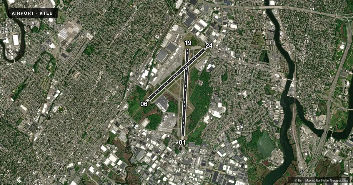
Runways & pattern
Full pagePattern entry · RWY 01
LEFT TRAFFIC| Runway | Heading (°M) | Length | Surface | Traffic |
|---|---|---|---|---|
| 01/19 | 351° / 171° | 6,997 ft | ASPH | Standard L |
| 06/24 | 36° / 216° | 6,014 ft | ASPH | Standard L |
Runway end performance
| End | TORA | TODA | ASDA | LDA | VGSI | Approach lights | Obstruction |
|---|---|---|---|---|---|---|---|
| 01 | 6,997' | 6,997' | 6,929' | 6,159' | PAPI 4-box left(3.1°) | — | 88', tree, 802' from thr, 524' R of cntrln, slope 7 |
| 19 | 6,997' | 6,997' | 6,997' | 6,230' | PAPI 4-box left(3°) | — | 263', bldg, 9256' from thr, 319' R of cntrln, slope 34 |
| 06 | 6,014' | 6,014' | 6,014' | 6,014' | — | MALSR | 148', tree, 5950' from thr, 1293' R of cntrln, slope 38 |
| 24 | 6,014' | 6,014' | 6,014' | 6,014' | PAPI 4-box left(3.2°) | — | 77', tree, 1705' from thr, 462' R of cntrln, slope 19 |
Declared distances in feet. TORA = takeoff run available, TODA = takeoff distance, ASDA = accelerate-stop, LDA = landing distance.
Airport sketch
Runways drawn to scale from FAA survey coordinates, rendered over satellite imagery. Not for navigation.
Approaches & charts
ILS · 2
Services on the field
Fuel grades, oxygen, maintenance, ramp storage and lighting — as declared to the FAA by the airport operator.
Fuel & services
- Fuel
- 100LLA
- Oxygen (bottled)
- HIGH/LOW
- Oxygen (bulk)
- HIGH/LOW
- Airframe repair
- Major
- Power plant repair
- Major
- Other services
- AVNCS,CARGO,CHTR,SALES
Ramp & ground
- Transient storage
- Tie-down
- Hangar
- Landing fee
- Yes
- Customs
- Not available
- Lighting schedule
- SS-SR
- Beacon schedule
- SS-SR
- Beacon
- White / Green (civil land)(WG)
- Wind indicator
- Lighted
- Segmented circle
- No
Fuel & FBOs
Cheapest 100LL and Jet A on the field and nearby. Always confirm with the FBO before taxi.
Airport notes
Surface conditions, obstructions, local procedures, lighting outages and other notes published with each FAA cycle.
General notes
- CLSD TO MOTORLESS ACFT - UNCTLD ACFT & ULTRALIGHT ACTIVITY EXCEP BY PRIOR PERMISSION.
- ALL ACFT AVOID HOSPITAL 1.7 MILE NORTH OF RWY 01/19.
- DEER AND BIRD ACT ON AND INVOF ARPT.
- HEL OPNS OVER RESIDENTIAL AREAS BLO 1000 FT MSL SHOULD BE AVOIDED.
- ACFT & HELICOPTER NOISE ABATEMENT RULES IN EFF; CTC ARPT NOISE ABATEMENT OFC 201-393-0399/288-1775 FOR COPY OF PROCEDURES & RULES PRIOR TO ARR. RY 24 NOISE CRITICAL RY MAX NOISE LIMIT OF 80 DB BETWEEN 2200-0700 & 90 DB ALL OTR HRS.
- STAGE 1 ACFT NOT PERMITTED TO OPR AT TETERBORO ARPT.
- DLY CONS CONST ACT ALL QUADRANTS.
- ACFT CAPABLE OF OPERATING ABV 100,000 POUNDS MUST SUBMIT CERTIFICATION TO AMGR VERIFYING AIRCRAFT OPERATING WEIGHT IS LESS THAN 100,000 LBS. CONTACT AIRPORT OPERATIONS AT 201-288-1775 FOR FORMS.
- TEB RNAV (GPS) X RWY 06 IS PRIM RNAV APCH TO RWY 06.
Runway surface & condition
- 01/19PCR VALUE: 459/F/D/X/T
- 06/24PCR VALUE: 343/F/D/X/T
Approach & departure obstructions
- 01RWY 01/19 DTHR CNTRLN LGTS OTS INDEFLY.
- 01RWY 01 67 FT TREE DIST 1200 FT, 400 FT RIGHT, 16:1 BASED ON DTHR.
- 19RWY 19 APCH RATIO 25:1 TO DTHR.
Arresting gear
- 06_EMASEMAS NON-STD ARRESTING GEAR/SYSTEM: ENGINEERED MATERIALS ARRESTING SYSTEM (EMAS) 250 FT IN LENGTH BY 170 FT WIDTH LCTD AT DEP END RWY 06.
- 19_EMASENGINEERED MATERIALS ARRESTING SYSTEM (EMAS) 355 FT IN LENGTH BY 162 FT WIDTH LCTD AT DEP END RWY 19.
- 24_EMASENGINEERED MATERIALS ARRESTING SYSTEM (EMAS) 348 FT IN LENGTH BY 162 FT WIDTH LCTD AT DEP END RWY 24.
Other notes
- ARFF INDEX B EQUIPMENT COVERAGE PRVDD.
- TPA 1500 FT MSL FOR LARGE/TURBINE ACFT; 1000 FT MSL FOR ALL OTHERS.
- ARPT OPS FREQUENCY 130.575.
VFR map & nearby airports
VFR sectional. Tap any ICAO chip to open that airport.
Key facts · KTEB
Answer card- ICAO
- KTEB
- Name
- TETERBORO
- Location
- TETERBORO, NEW JERSEY
- Elevation
- 8.3 ft MSL
- Traffic pattern altitude
- 1,008.3 ft MSL (1,000 AGL)
- Control tower
- Towered · 24
- Total runways
- 2
- Longest runway
- 01/19 · 6,997 ft
- Published ILS approaches
- 2
- Published frequencies
- 13
- Magnetic variation
- 12°
- Current flight rules
- VFR
- Current wind
- 000° at 0 kt
- Favored runway now
- –
Teterboro Airport sits in Teterboro, New Jersey, just west of Manhattan. Field elevation is 8.3 ft MSL. The airport has two asphalt runways. The longest is 01/19 at 6,997 ft. Tower service is 24 hours.
Two ILS approaches are published. They serve runway ends 06 and 19. Pattern altitude is 1,500 ft MSL for large and turbine aircraft. Pattern altitude is 1,000 ft MSL for all others. First-time arrivals should pay close attention to the noise program. Aircraft and helicopter noise abatement rules are in effect. Runway 24 is noise critical. Published decibel limits apply at night and during the day. Check the current FAA Chart Supplement and airport operator guidance before you go.
On the field, Signature Aviation - East, Atlantic Aviation, Signature Aviation - Legacy West, Signature Aviation - South, Signature Aviation - West and Jet Aviation Teterboro are listed. 100LL is available at Signature Aviation - East, Atlantic Aviation, Signature Aviation - Legacy West and Signature Aviation - West. Jet A is carried by all listed FBOs except the 100LL-only side of the field does not apply here. Runway 01 has a tree obstruction near the threshold area. EMAS is published at the departure ends of 06, 19 and 24. The airport is closed to motorless aircraft except by prior permission. Aircraft above 100,000 lb must have airport approval on file.