METAR & TAF KLGA
Current METAR
Observed 09:51Z
KLGA 270951Z 22003KT 10SM FEW080 SCT130 BKN250 23/17 A2981 RMK AO2 SLP094 T02280167 $
- Wind
- 220° @ 3 kt
- Visibility
- 10 SM
- Temp / Dew
- 23°C / 17°C
- Altimeter
- 29.81 inHg
- Clouds
- BKN
- Density alt
- 1,122 ft
- Ceiling
- 25,000 ft AGL
- Rules
- VFR
Airport info & contacts
Manager on record, flight service, ARTCC, attendance schedule and pattern altitude — published by the FAA and refreshed every 28 days.
Location
- From city
- 4 NM E
- VFR sectional
- NEW YORK
- ARTCC
- ZNY · NEW YORK
- NOTAM facility
- LGA (NOTAM-D)
Airport manager
- Name
- ANTHONY VERO
- Phone
- 718-533-3401
- Address
- HANGAR #7, THIRD FLOOR, FLUSHING NY 11371
Flight service · Hours
- FSS ISP
- NEW YORK1-800-WX-BRIEF
- Attendance
- ALL
Frequencies
Tap any row to copy the frequency to your clipboard.
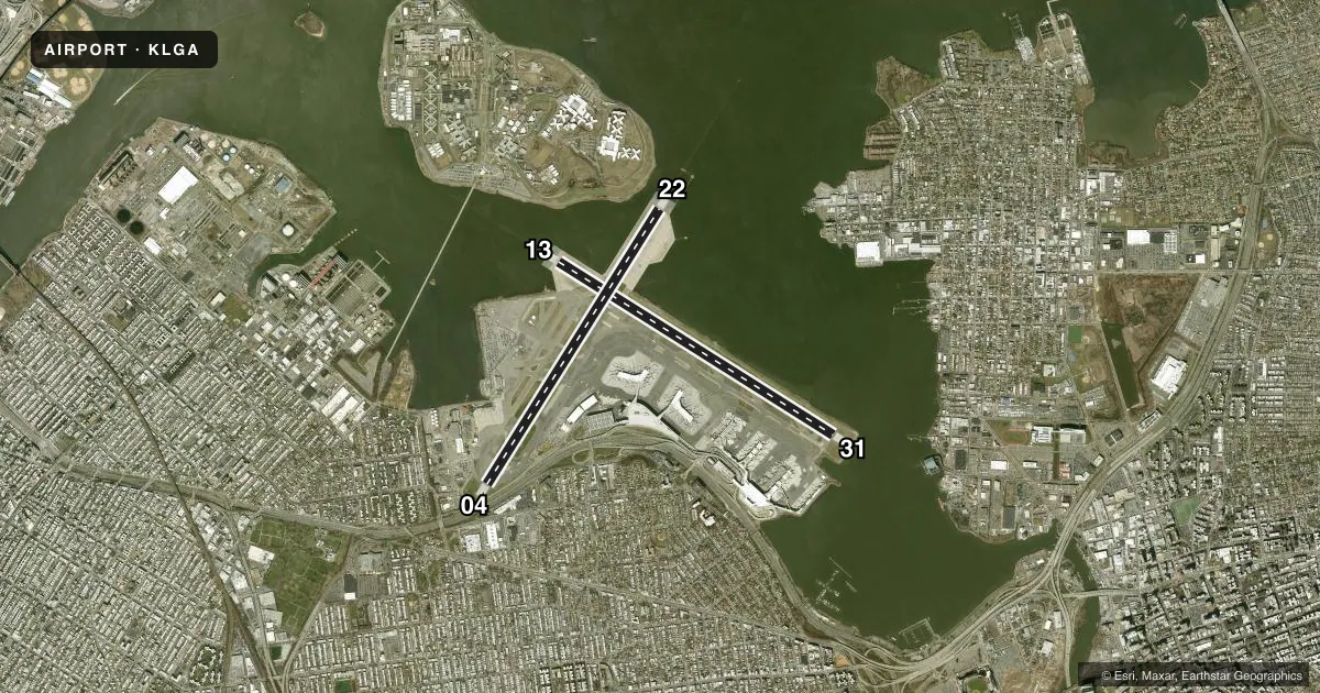
Runways & pattern
Full pagePattern entry · RWY 22
LEFT TRAFFIC| Runway | Heading (°M) | Length | Surface | Traffic |
|---|---|---|---|---|
| 04/22Favored | 20° / 200° | 7,002 ft | ASPH-CONC | Standard L |
| 13/31 | 110° / 290° | 7,002 ft | ASPH-CONC | Standard L |
Runway end performance
| End | TORA | TODA | ASDA | LDA | VGSI | Approach lights | Obstruction |
|---|---|---|---|---|---|---|---|
| 04 | 7,002' | 7,002' | 7,002' | 7,002' | PAPI 4-box right(3.14°) | MALSR | 80', bldg, 2950' from thr, 400' R of cntrln, slope 34 |
| 22 | 7,002' | 7,002' | 7,002' | 7,002' | PAPI 4-box right(3°) | ALSF1 | — |
| 13 | 7,002' | 7,002' | 7,002' | 7,002' | PAPI 4-box left(3.1°) | MALSR | — |
| 31 | 7,002' | 7,002' | 7,002' | 7,002' | PAPI 4-box right(3°) | — | 95', bldg, 2750' from thr, 510' R of cntrln, slope 26 |
Declared distances in feet. TORA = takeoff run available, TODA = takeoff distance, ASDA = accelerate-stop, LDA = landing distance.
Airport sketch
Runways drawn to scale from FAA survey coordinates, rendered over satellite imagery. Not for navigation.
Approaches & charts
ILS · 4
Services on the field
Fuel grades, oxygen, maintenance, ramp storage and lighting — as declared to the FAA by the airport operator.
Fuel & services
- Fuel
- 100LLA
- Oxygen (bottled)
- HIGH/LOW
- Oxygen (bulk)
- HIGH/LOW
- Airframe repair
- Major
- Power plant repair
- Major
- Other services
- AFRT,AVNCS,CARGO,CHTR
Ramp & ground
- Transient storage
- Tie-down
- Landing fee
- Yes
- Customs
- Not available
- Beacon schedule
- SS-SR
- Beacon
- White / Green (civil land)(WG)
- Wind indicator
- Lighted
- Segmented circle
- No
Fuel & FBOs
Cheapest 100LL and Jet A on the field and nearby. Always confirm with the FBO before taxi.
Airport notes
Surface conditions, obstructions, local procedures, lighting outages and other notes published with each FAA cycle.
General notes
- FLOCKS OF BIRDS ON & INVOF ARPT.
- SPECIAL AIR TFC RULES-PART 93; HIGH DENSITY ARPT; PRIOR RSVN RQRD; SEE AIM.
- MAG ANOMALIES MAY AFFECT COMPASS HDG WHEN USING EXTENSION RWYS 13 & 22 FOR TKOF.
- TWYS G, P, R & U CONCRETE DECK RSTD TO 5KT TURNS; 10KTS STRAIGHT.
- CODED TRANSPONDER RQRD. VFR RSVN INFO AVBL ON ATIS.
- SHIP MASTS IN APCH RWY 31.
- FOR NOISE ABATEMENT RSTRNS CALL 212-435-3782 DURG NML BUS HRS.
- B767-400 ACFT RSTRD TO 10 KTS ON TWYS DD, Z, B & AA.
- TWYS F & D WEST OF TWY BB CLSD TO ACFT WITH WINGSPANS IN EXCESS OF 125 FT.
- OBST SIGN STRUCTURE UNKN (39 AGL) 500 FT E RWY 4/22 CNTRLN & 4800 FT S RWY 13/31 CNTRLN.
- RUNWAY STATUS LIGHTS IN OPERATION.
- OVHD PAX BRIDGES ON N SIDE OF TERMINAL B PRVD 50 FT TAIL HGT CLNC WHEN ON TAXILANE CNTRLN.
- RWY 13/31: NW 944 FT OF RWY IS A DECK OVR WTR; RWY FRICTION MAY BE DIFFERENT THAN RMNG PTN OF RWY DURG WINT WX.
- RWY 04/22: NE 1776 FT OF RWY IS A DECK OVR WTR; RWY FRICTION MAY BE DIFFERENT THAN RMNG PTN OF RWY DURG WINT WX.
- ACFT OPS & TWY WT RSTRNS EXIST FOR ADG-III & ADG-IV. PLEASE CTC LGA ARPT OPS AT 718-533-3700 FOR MORE INFO.
Runway surface & condition
- 04/22PCR VALUE: 530/F/A/X/T
- 13/31PCR VALUE: 577/F/B/X/T
Approach & departure obstructions
- 04+11 FT FENCE 245 FT RIGHT OF RWY END.
- 13PAPI RWY 13 UNUSBL 8 DEGS LEFT OF CNTRLN AND 9 DEGS RIGHT OF CNTRLN.
Arresting gear
- 04_EMASENGINEERED MATERIALS ARRESTING SYSTEM (EMAS) 215 FT IN LENGTH BY 170 FT IN WIDTH LCTD AT THE DER 04.
- 13_EMASEMAS PARTIALLY DAMAGED RESULTING IN REDUCED ARRESTING CAPABILITY. ENGINEERED MATERIALS ARRESTING SYSTEM (EMAS) 327 FT IN LENGTH BY 170 FT IN WIDTH LCTD AT THE DER 13.
- 22_EMASENGINEERED MATERIALS ARRESTING SYSTEM (EMAS) 272 FT IN LENGTH BY 170 FT IN WIDTH LCTD AT THE DER 22.
- 31_EMASENGINEERED MATERIALS ARRESTING SYSTEM (EMAS) 215 FT IN LENGTH BY 170 FT IN WIDTH LCTD AT THE DER 31.
Other notes
- MANAGERPORT AUTHORITY OF NEW YORK AND NEW JERSEY.
- OWNERLEASEE. PROPERTY OWNED BY THE CITY OF NEW YORK.
VFR map & nearby airports
VFR sectional. Tap any ICAO chip to open that airport.
Key facts · KLGA
Answer card- ICAO
- KLGA
- Name
- LAGUARDIA
- Location
- NEW YORK, NEW YORK
- Elevation
- 20.7 ft MSL
- Traffic pattern altitude
- 1,020.7 ft MSL (1,000 AGL)
- Control tower
- Towered · 24
- Total runways
- 2
- Longest runway
- 04/22 · 7,002 ft
- Published ILS approaches
- 4
- Published frequencies
- 36
- Magnetic variation
- 12°
- Current flight rules
- VFR
- Current wind
- 220° at 3 kt
- Favored runway now
- RWY 22
LaGuardia Airport is in New York, New York. Field elevation is 20.7 ft MSL. It has two runways. Both are 7,002 ft long. The tower is open 24 hours. The field sits under Part 93 special air traffic rules, so this is a high-density airport with a prior reservation requirement. Check current procedures before you go.
Runway 04/22 and runway 13/31 both have ILS approaches available. The published pattern altitude is not listed, so use the standard 1,000 ft AGL for light piston traffic unless ATC gives you something different. That puts the pattern at about 1,021 ft MSL based on the published field elevation. The on-field FBO is Modern Aviation. It carries 100LL, Jet A and Jet A Prist. For a first-time arrival, pay close attention to the published runway and taxiway notes. Taxiways G, P, R and U have tight turn and straight-speed limits. Taxiways F and D west of BB are closed to aircraft with wingspans over 125 ft. Runway 04/22 also has a deck-over-water section on the northeast end, so winter braking can vary there. Magnetic anomalies are also noted on extension runways 13 and 22. This is a busy Class B environment. Get the current Chart Supplement and coordinate closely with ATC.