METAR & TAF KSUS
Current METAR
Observed 18:54Z
KSUS 271854Z 23011KT 6SM HZ CLR 35/25 A2979 RMK AO2 SLP076 T03500250 $
- Wind
- 230° @ 11 kt
- Visibility
- 6 SM
- Temp / Dew
- 35°C / 25°C
- Altimeter
- 29.79 inHg
- Clouds
- CLR
- Density alt
- 3,136 ft
- Ceiling
- Unlimited
- Rules
- VFR
Airport info & contacts
Manager on record, flight service, ARTCC, attendance schedule and pattern altitude — published by the FAA and refreshed every 28 days.
Location
- From city
- 17 NM W
- VFR sectional
- ST LOUIS
- Pattern altitude
- 1,273 ft AGL · 1,736 ft MSL
- ARTCC
- ZKC · KANSAS CITY
- NOTAM facility
- SUS (NOTAM-D)
Airport manager
- Name
- MR. JOHN D. BALES
- Phone
- 636-532-2222
- Address
- SPIRIT OF ST LOUIS AIRPORT, 18270 EDISON AVENUE, CHESTERFIELD MO 63005-3704
Flight service · Hours
- FSS STL
- SAINT LOUIS1-800-WX-BRIEF
- Attendance
- ALL
Frequencies
Tap any row to copy the frequency to your clipboard.
Runways & pattern
Full pagePattern entry · RWY 26L
LEFT TRAFFIC| Runway | Heading (°M) | Length | Surface | Traffic |
|---|---|---|---|---|
| 08R/26LFavored | 77° / 257° | 7,486 ft | CONC | 08R R |
| 08L/26R | 77° / 257° | 5,000 ft | ASPH | 26R R |
Runway end performance
| End | TORA | TODA | ASDA | LDA | VGSI | Approach lights | Obstruction |
|---|---|---|---|---|---|---|---|
| 08R | 7,486' | 7,486' | 7,225' | 7,225' | VASI 2-box right(3°) | MALSR | — |
| 26L | 7,486' | 7,486' | 7,486' | 7,005' | VASI 2-box left(3°) | MALSR | — |
| 08L | 5,000' | 5,000' | 5,000' | 5,000' | PAPI 4-box left(3°) | — | — |
| 26R | 5,000' | 5,000' | 5,000' | 5,000' | VASI 2-box left(3.5°) | — | 31', pole, 1200' from thr, 150' R of cntrln, slope 32 |
Declared distances in feet. TORA = takeoff run available, TODA = takeoff distance, ASDA = accelerate-stop, LDA = landing distance.
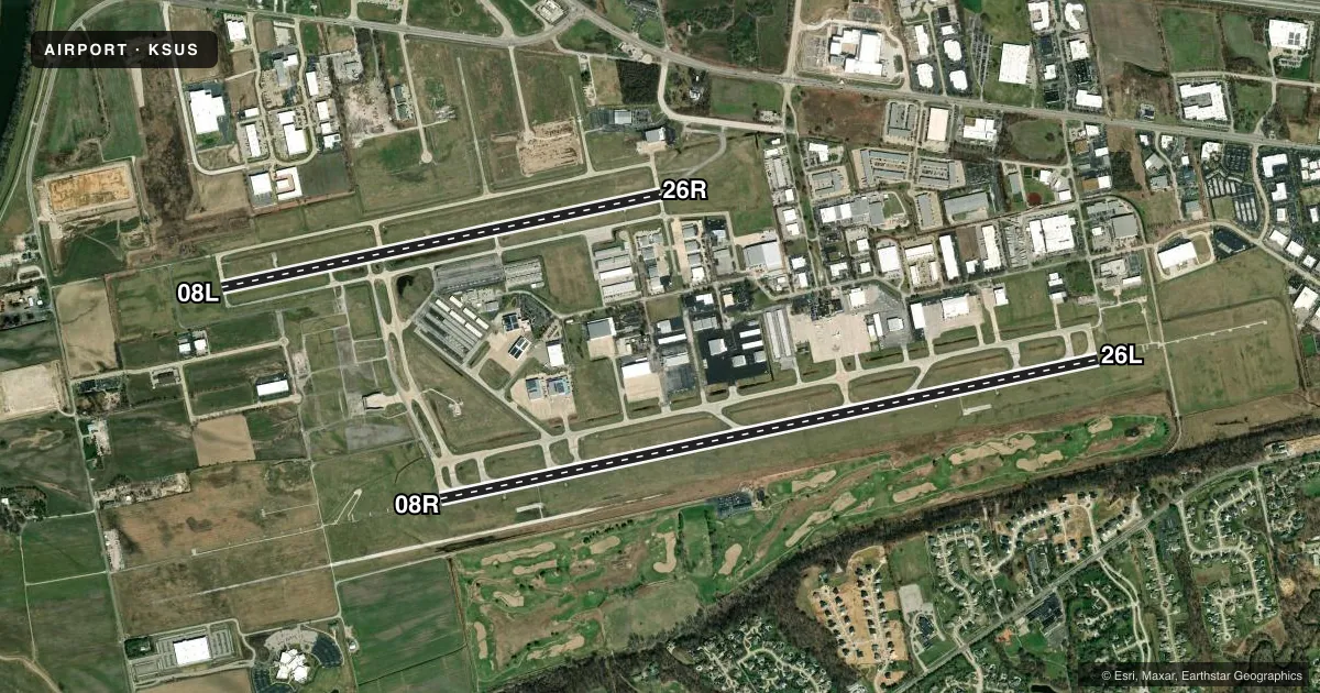
Airport sketch
Runways drawn to scale from FAA survey coordinates, rendered over satellite imagery. Not for navigation.
Approaches & charts
ILS · 2
Services on the field
Fuel grades, oxygen, maintenance, ramp storage and lighting — as declared to the FAA by the airport operator.
Fuel & services
- Fuel
- 100LLA
- Oxygen (bottled)
- Low pressure
- Oxygen (bulk)
- Low pressure
- Airframe repair
- Major
- Power plant repair
- Major
- Other services
- AFRT,AMB,AVNCS,CHTR,INSTR,RNTL,SALES,SURV
Ramp & ground
- Transient storage
- Tie-down
- Hangar
- Landing fee
- No fee published
- Customs
- Not available
- Lighting schedule
- SEE RMK
- Beacon schedule
- SS-SR
- Beacon
- White / Green (civil land)(WG)
- Wind indicator
- Yes
- Segmented circle
- No
Fuel & FBOs
Cheapest 100LL and Jet A on the field and nearby. Always confirm with the FBO before taxi.
Airport notes
Surface conditions, obstructions, local procedures, lighting outages and other notes published with each FAA cycle.
General notes
- BE ALERT; NOISE SENSITIVE AREAS TO THE SOUTH OF ARPT.
- TWY B BETWEEN SE & NW ENTRANCE TO WEST RAMP, TWY B NW TWY A FM THE DSTC OF 200 FT TO 700 FT & TWY Z NOT VSB BY TWR.
- NMRS & INTS HEL OPS ON ARPT.
- INT C CLSD INDEFLY BTWN TWY E & RWY 08L/26R.
- NOISE ABATEMENT PROCS: FOR DEP STAGE III ACFT USE 08L/26R 2300-0600.
- ALL MAINT-HI PWR ENG RUN-UPS USE GND RUN-UP ENCLOSURE ON TWY D.
- ARPT CLSD TO ACFT OVER 100,000 LBS; EXCEPT ACFT 100,000-150,000 LBS FOR PPR 24 HRS CALL AMGR 636-532-1858.
- NOISE ABATEMENT PROC IN EFCT: FOR DEP STAGE II ACFT USE RWY 08L/26R 2200-0700 EXCP PPR 636-532-2222 MON-FRI 0800-1700, OTR TIMES CALL 314-568-0581/0584, 636-536-2877, OR 636-441-9231.
- TAXILANE B BTWN SOUTH ENTRANCE WEST RAMP AND TWY Z CLSD.
- BRGT DRIVING RANGE LGTS 2.7 NM EAST OF RWY 26L.
- 24 HR PPR FOR ALL MIL ACFT, CTC 636-532-2222.
Lighting notes
- ATC-CTL. HIRL RY 08R/26L PRESET ON MED INTST 2300-0600; MIRL RY 08L/26R PRESET ON LOW INTST 2300-0600. TO INCR INTST AFT 2300 AND ACTVT MALSR RY 08R & 26L - CTAF.
Runway surface & condition
- 08L/26RPCR VALUE: 100/F/D/X/T
- 08R/26LPCR VALUE: 310/R/C/W/T
- 08L/26RRWY 08L/26R NOT AVBL FOR PART 121/PART 380 OPS WITH SKED PAX CARRYING OPS MORE THAN 9 PAX SEATS AND NON-SKED PAX CARRYING OPS MORE THAN 30 PAX SEATS. & PARALLEL & CONNECTING TWY CLSD TO PART 121 ACR OPNS.
- 08R/26LRY 08R/26L CLSD TO TGL.
Other notes
- FLIGHT NOTIFICATION SERVICE (ADCUS) AVBL 1700-0830 MON-FRI; 24 HRS SAT & SUN.
- PPR 24 HRS FOR ACR OPNS WITH MORE THAN 30 PSGR SEATS; CALL AMGR 314-568-0584. AIR CARRIER OPNS OVER 9 PSGR SEATS NOT AUTHORIZED IN EXCESS OF 15 MIN BEFORE OR AFTER SCHEDULED ARRIVAL/DEPARTURE TIMES EXCEPT PRIOR COORD WITH AMGR FOR ARFF 314-568-0584.
- TPA RWY 08R/26L PROP 1237 FT AGL, RWY 08L/26R PROP 837 FT AGL. TPA JETS 1537 FT AGL.
VFR map & nearby airports
VFR sectional. Tap any ICAO chip to open that airport.
Key facts · KSUS
Answer card- ICAO
- KSUS
- Name
- SPIRIT OF ST LOUIS
- Location
- ST LOUIS, MISSOURI
- Elevation
- 463.3 ft MSL
- Traffic pattern altitude
- 1,736.3 ft MSL (1,273 AGL)
- Control tower
- Towered · 0600-2300
- Total runways
- 2
- Longest runway
- 08R/26L · 7,486 ft
- Published ILS approaches
- 2
- Published frequencies
- 10
- Magnetic variation
- 1°
- Current flight rules
- VFR
- Current wind
- 230° at 11 kt
- Favored runway now
- RWY 26L
Spirit of St Louis Airport sits in St Louis, Missouri. Field elevation is 463.3 ft MSL. The airport has 2 runways. The longest is 7,486 ft on 08R/26L. The other runway is 5,000 ft on 08L/26R. The tower is open 0600 to 2300. Two ILS approaches are published. They serve runway ends 08R and 26L. Pattern altitude is 1,736.3 ft MSL, which is 1,273 ft AGL.
This is a busy field. Published remarks call out numerous helicopter operations. Noise abatement is active. Stage II aircraft departing should use runway 08L/26R from 2200 to 0700 unless prior permission is arranged. The airport also has lighting notes for night use. After 2300, runway lights are preset to lower settings. Use CTAF if you need to increase intensity or bring on the medium intensity approach lighting system with runway alignment indicator lights.
Three on-field FBOs are listed. Signature Aviation, Aero Charter Jet Center and Million Air all carry 100LL, Jet A and Jet A Prist. First-time pilots should pay close attention to taxi instructions. Some taxiways are not visible from the tower. Runway 08R/26L is closed to touch-and-go landings. Check the current FAA Chart Supplement before flight for the latest restrictions and any operational changes.