METAR & TAF KSTP
Current METAR
Observed 19:53Z
KSTP 271953Z 32013G21KT 10SM CLR 38/17 A2968 RMK AO2 SLP041 T03780167
- Wind
- 320° @ 13G21 kt
- Visibility
- 10 SM
- Temp / Dew
- 38°C / 17°C
- Altimeter
- 29.68 inHg
- Clouds
- CLR
- Density alt
- 3,932 ft
- Ceiling
- Unlimited
- Rules
- VFR
Airport info & contacts
Manager on record, flight service, ARTCC, attendance schedule and pattern altitude — published by the FAA and refreshed every 28 days.
Location
- From city
- 1 NM S
- VFR sectional
- TWIN CITIES
- Pattern altitude
- 1,200 ft AGL · 1,905 ft MSL
- ARTCC
- ZMP · MINNEAPOLIS
- NOTAM facility
- STP (NOTAM-D)
Airport manager
- Name
- BLAINE PETERSON
- Phone
- 651-224-4306
- Address
- 644 BAYFIELD, ST PAUL MN 55107
Flight service · Hours
- FSS PNM
- PRINCETON1-800-WX-BRIEF
- Attendance
- ALL
Frequencies
Tap any row to copy the frequency to your clipboard.
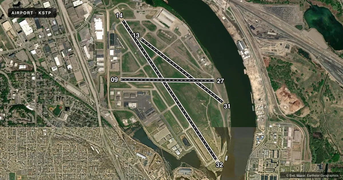
Runways & pattern
Full pagePattern entry · RWY 32
LEFT TRAFFIC| Runway | Heading (°M) | Length | Surface | Traffic |
|---|---|---|---|---|
| 14/32Favored | 146° / 326° | 6,491 ft | ASPH | Standard L |
| 13/31 | 128° / 308° | 4,004 ft | ASPH | Standard L |
| 09/27 | 91° / 271° | 3,642 ft | ASPH | 27 R |
Runway end performance
| End | TORA | TODA | ASDA | LDA | VGSI | Approach lights | Obstruction |
|---|---|---|---|---|---|---|---|
| 14 | 6,491' | 6,491' | 6,491' | 6,148' | PAPI 4-box right(3°) | MALSR | 12', road, 586' from thr, 0' R of cntrln, slope 32 |
| 32 | 6,491' | 6,491' | 6,491' | 6,109' | PAPI 4-box left(3°) | — | 60', trees, 1728' from thr, 100' R of cntrln, slope 25 |
| 13 | 4,004' | 4,004' | 4,004' | 4,004' | PAPI 4-box left(3°) | — | — |
| 31 | 4,004' | 4,004' | 4,004' | 4,004' | PAPI 4-box left(3°) | — | 9', brush, 311' from thr, 32' R of cntrln, slope 12 |
| 09 | 3,642' | 3,642' | 3,642' | 3,642' | — | — | 33', tree, 663' from thr, 160' R of cntrln, slope 14 |
| 27 | 3,642' | 3,642' | 3,642' | 3,642' | PAPI 4-box right(4°) | — | 12', tree, 284' from thr, 118' R of cntrln, slope 7 |
Declared distances in feet. TORA = takeoff run available, TODA = takeoff distance, ASDA = accelerate-stop, LDA = landing distance.
Airport sketch
Runways drawn to scale from FAA survey coordinates, rendered over satellite imagery. Not for navigation.
Approaches & charts
ILS · 2
Services on the field
Fuel grades, oxygen, maintenance, ramp storage and lighting — as declared to the FAA by the airport operator.
Fuel & services
- Fuel
- 100LLA
- Oxygen (bottled)
- Not available
- Oxygen (bulk)
- HIGH/LOW
- Airframe repair
- Major
- Power plant repair
- Major
- Other services
- AMB,AVNCS,CHTR,INSTR,RNTL,SALES
Ramp & ground
- Transient storage
- Tie-down
- Hangar
- Landing fee
- Yes
- Customs
- Not available
- Lighting schedule
- SEE RMK
- Beacon schedule
- SS-SR
- Beacon
- White / Green (civil land)(WG)
- Wind indicator
- Lighted
- Segmented circle
- No
Fuel & FBOs
Cheapest 100LL and Jet A on the field and nearby. Always confirm with the FBO before taxi.
Airport notes
Surface conditions, obstructions, local procedures, lighting outages and other notes published with each FAA cycle.
General notes
- BIRD ROOSTING & FEEDING AREAS ALONG RIVER BANKS.
- WHEN USING RWYS 27 OR 31 HAZARDOUS RIVER TFC MAY EXIST.
- DEER, BIRDS & WILDLIFE ON & INVOF ARPT.
- SE ARR & DEP AVOID TFC PATTERN OPS AT SOUTH ST. PAUL ARPT 164 DEG 5 NM AT & BLO 1720 MSL.
- PPR ACFT OVER 100,000 LBS, CTC AMGR.
- COMPLEX AIRPORT GEOMETRY. VERIFY CORRECT COMPASS HEADING PRIOR TO DEPARTURE.
- VOLUNTARY NOISE ABATEMENT PROCS IN EFCT. SEE ARPT WEBSITE FOR MORE INFO.
- TWY A CLSD BTN A3 AND A4 EXC FOR WINGSPAN LESS THAN 101FT.
- TWY B CLSD BTN MN JET RAMP AND TWY A (SOUTHERN CORNER) EXC FOR WINGSPAN LESS THAN 72FT DUE TO FLOOD WALL OBSTACLE.
- RWY 14 IS CALM WIND RWY WHEN ATCT CLSD.
- EXPECT HELICOPTER OPERATIONS ON TWY 'A' IN THE VICINITY OF THE CONTROL TWR, NORTH TO THE APPROACH END OF RWY 14.
- COLD TEMPERATURE AIRPORT. ALTITUDE CORRECTION REQUIRED AT OR BELOW -30C.
- WHEN ATCT CLSD, FOR CD CTC MINNEAPOLIS APCH ON 121.675.
Lighting notes
- AIRPORT BEACON ON WEST EDGE OF ARPT.
- WHEN ATCT CLSD, TO INCR INTST & ACTVT MALSR RWY 14; REIL RWY 31; PAPI RWY 13, 27, & 31; HIRL RWY 14/32 & 13/31; MIRL RWY 09/27; - CTAF. RWY 14 & 32 PAPI OPS CONSLY.
Fuel notes
- AJET A LANDING FEE, CTC FBO.
Approach & departure obstructions
- 14RY 14: ROAD +13 179 FM END, 494R.
- 32+8' TREE 95' FM RY END 380'R OF CNTRLN.
- 13PAPI UNUSBL BYD 4 DEG RIGHT OF CNTRLN & UNUSBL INSIDE .5 NM.
- 14PAPI UNUSBL BYD 8 DEG LEFT OF CNTRLN.
- 14RY 14 APCH RATIO 45:1 TO DISPL THSD FOR ROAD +13, 179 FM END, 494R.
- 32RY 32 APCH RATIO 34:1 TO DSPLCD THR.
Arresting gear
- 14_EMASENGINEERED MATERIALS ARRESTING SYSTEM (EMAS) 280 FT IN LENGTH BY 162 FT IN WIDTH LCTD AT THE DER 14.
- 32_EMASENGINEERED MATERIALS ARRESTING SYSTEM (EMAS) 225 FT IN LENGTH BY 162 FT IN WIDTH LCTD AT THE DER 32.
Other notes
- SPB ESTABLISHED PRIOR TO 1959.
- CUSTOMS 0800-1630 DLY - OTR HRS, ONE HR PPR THRU FSS.
- MANAGEREMAIL ADDRESS: BLAINE.PETERSON@MSPMAC.ORG
- MANAGERMAINT SUPVR, 612-919-5370 OR 612-919-5372, MON-FRI 0600-2200.
- MANAGER651-224-4306
VFR map & nearby airports
VFR sectional. Tap any ICAO chip to open that airport.
Key facts · KSTP
Answer card- ICAO
- KSTP
- Name
- ST PAUL DOWNTOWN HOLMAN FLD
- Location
- ST PAUL, MINNESOTA
- Elevation
- 705 ft MSL
- Traffic pattern altitude
- 1,905 ft MSL (1,200 AGL)
- Control tower
- Towered · 0600-2200 MON-FRI, 0700-2200 SAT-SUN
- Total runways
- 3
- Longest runway
- 14/32 · 6,491 ft
- Published ILS approaches
- 2
- Published frequencies
- 14
- Magnetic variation
- 0°
- Current flight rules
- VFR
- Current wind
- 320° at 13 kt
- Favored runway now
- RWY 32
KSTP is in St Paul, Minnesota. The field elevation is 705 ft MSL. It has three asphalt runways. The longest is runway 14/32 at 6,491 ft. The airport is towered. Tower hours are 0600-2200 Monday through Friday. Weekend tower hours are 0700-2200.
Two ILS approaches are published here. They serve runway ends 14 and 32. Pattern altitude is 1,200 ft AGL. That puts the traffic pattern at 1,905 ft MSL. Magnetic variation is 0°, so the runway headings in the chart data are already magnetic.
Signature Aviation is on the field. It carries 100LL, Jet A and Jet A Prist. St. Paul Flight Center is also on the field. It carries 100LL, Jet A and Jet A Prist. Expect helicopter traffic on taxiway A near the tower and north toward the approach end of runway 14. Voluntary noise abatement procedures are in effect. Check the current FAA Chart Supplement for the details before you go.
A few other items matter here. Taxiway B is restricted near the southern corner because of the flood wall obstacle. Deer, birds and other wildlife are reported on and near the airport. Runways 27 and 31 can have hazardous river traffic nearby. This field is also listed as a cold temperature airport. Use altitude correction at or below minus 30 degrees Celsius.