METAR & TAF KSEM
Current METAR
Observed 12:55Z
KSEM 271255Z AUTO 31003KT 8SM BKN038 26/26 A2996 RMK AO2 LTG DSNT NE
- Wind
- 310° @ 3 kt
- Visibility
- 8 SM
- Temp / Dew
- 26°C / 26°C
- Altimeter
- 29.96 inHg
- Clouds
- BKN
- Density alt
- 1,476 ft
- Ceiling
- 3,800 ft AGL
- Rules
- VFR
Airport info & contacts
Manager on record, flight service, ARTCC, attendance schedule and pattern altitude — published by the FAA and refreshed every 28 days.
Location
- From city
- 4 NM SE
- VFR sectional
- ATLANTA
- ARTCC
- ZTL · ATLANTA
- NOTAM facility
- ANB (NOTAM-D)
Airport manager
- Name
- DAN LANE
- Phone
- 334-419-3881
- Address
- CRAIG FIELD INDUSTRIAL, HANGAR 202, AVENUE J, SELMA AL 36701
Flight service · Hours
- FSS ANB
- ANNISTON1-800-WX-BRIEF
- Attendance
- 0800-1800
Frequencies
Tap any row to copy the frequency to your clipboard.
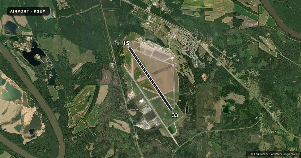
Runways & pattern
Full pagePattern entry · RWY 33
LEFT TRAFFICRunway end performance
| End | TORA | TODA | ASDA | LDA | VGSI | Approach lights | Obstruction |
|---|---|---|---|---|---|---|---|
| 15 | — | — | — | — | PAPI 4-box left(3°) | — | 41', tree, 1249' from thr, 384' R of cntrln, slope 25 |
| 33 | — | — | — | — | PAPI 4-box left(3°) | MALS | 43', tree, 1620' from thr, 336' R of cntrln, slope 33 |
Declared distances in feet. TORA = takeoff run available, TODA = takeoff distance, ASDA = accelerate-stop, LDA = landing distance.
Airport sketch
Runways drawn to scale from FAA survey coordinates, rendered over satellite imagery. Not for navigation.
Approaches & charts
ILS · 1
Services on the field
Fuel grades, oxygen, maintenance, ramp storage and lighting — as declared to the FAA by the airport operator.
Fuel & services
- Fuel
- 100LLA
- Oxygen (bulk)
- Not available
- Airframe repair
- Major
- Power plant repair
- Major
- Other services
- INSTR
Ramp & ground
- Transient storage
- Tie-down
- Hangar
- Landing fee
- No fee published
- Customs
- Not available
- Lighting schedule
- SEE RMK
- Beacon schedule
- SS-SR
- Beacon
- White / Green (civil land)(WG)
- Wind indicator
- Lighted
- Segmented circle
- No
Fuel & FBOs
Cheapest 100LL and Jet A on the field and nearby. Always confirm with the FBO before taxi.
Airport notes
Surface conditions, obstructions, local procedures, lighting outages and other notes published with each FAA cycle.
General notes
- FOR CD IF UNA TO CTC ON FSS FREQ, CTC DANNELLY APCH AT 334-284-4575, WHEN ATCT CLSD CTC ATLANTA ARTCC AT 770-210-7692.
Lighting notes
- WHEN ATCT CLSD ACTVT MALS RWY 33; PAPI RWY 15/33 AND HIRL RWY 15/33 - CTAF.
Fuel notes
- 100LL24HR 100LL AND JET A AVBL CALL 334-651-1511 AFT HRS.
Approach & departure obstructions
- 15RWY ID AND TD MRKGS SEVERELY FADED.
- 33RWY ID AND TD MRKGS SEVERELY FADED.
Other notes
- OWNERJAMES CORRIGAN, EXECUTIVE DIRECTOR
- MANAGERALT 334-874-7419.
- 15/33SEVERE CRACKING EXISTS ON ALL RUNWAY SURFACES. REHABILITATION PROJECT IS PLANNED.
VFR map & nearby airports
VFR sectional. Tap any ICAO chip to open that airport.
Key facts · KSEM
Answer card- ICAO
- KSEM
- Name
- CRAIG FLD
- Location
- SELMA, ALABAMA
- Elevation
- 166.2 ft MSL
- Traffic pattern altitude
- 1,166.2 ft MSL (1,000 AGL)
- Control tower
- Towered · 0700-1900 MON-FRI; 0900-1700 SAT & SUN
- Total runways
- 1
- Longest runway
- 15/33 · 8,014 ft
- Published ILS approaches
- 1
- Published frequencies
- 6
- Magnetic variation
- 3°
- Current flight rules
- VFR
- Current wind
- 310° at 3 kt
- Favored runway now
- RWY 33
Craig Fld sits in Selma, Alabama. The field elevation is 166.2 ft MSL. It has one runway, 15/33, which is 8,014 ft long. The tower is open 0700-1900 Monday through Friday. Weekend hours are 0900-1700. There is one ILS approach. It serves runway 33. Pattern altitude is not published. Use 1,000 ft AGL for light piston traffic unless the current Chart Supplement says otherwise.
Selma FBO Flight Services is on the field. It carries 100LL and Jet A Prist. 24-hour 100LL and Jet A fuel are available. Call ahead after hours if you need fuel or service. Published remarks also note severe cracking on the runway surfaces. Markings on both runway ends are severely faded. That matters on rollout and at night. When the tower is closed, the medium intensity approach lighting for runway 33 can be activated. The PAPI and HIRL for runways 15 and 33 are on CTAF.
For a first-time arrival, the main things to plan for are runway condition, lighting and tower status. The airport uses Montgomery approach frequencies for radar services. If you need clearance delivery help when FSS is not reachable, the published remarks give a Dannelly Approach number. Check the current Chart Supplement before flight for the latest operational notes.