METAR & TAF KSBM
Current METAR
Observed 16:44Z
KSBM 271644Z AUTO 17008G19KT 5SM VCTS BR SCT007 SCT011 BKN016 25/24 A2967 RMK AO2 PK WND 22027/1622 LTG DSNT ALQDS RAB20E40 TSB11E33 P0026 T02500244
- Wind
- 170° @ 8G19 kt
- Visibility
- 5 SM
- Temp / Dew
- 25°C / 24°C
- Altimeter
- 29.67 inHg
- Clouds
- BKN
- Density alt
- 2,447 ft
- Ceiling
- 1,600 ft AGL
- Rules
- MVFR
Airport info & contacts
Manager on record, flight service, ARTCC, attendance schedule and pattern altitude — published by the FAA and refreshed every 28 days.
Location
- From city
- 3 NM NW
- VFR sectional
- CHICAGO
- ARTCC
- ZAU · CHICAGO
- NOTAM facility
- SBM (NOTAM-D)
Airport manager
- Name
- MATTHEW GRENOBLE
- Phone
- 920-467-2978
- Address
- N6193 RESOURCE DR., SHEBOYGAN FALLS WI 53085
Flight service · Hours
- FSS GRB
- GREEN BAY1-800-WX-BRIEF
- Attendance
- DAWN-DUSK
Frequencies
Tap any row to copy the frequency to your clipboard.
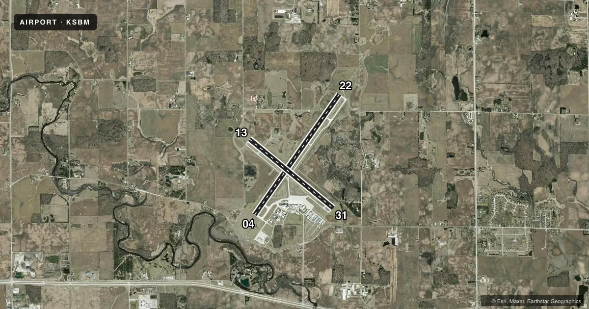
Runways & pattern
Full pagePattern entry · RWY 13
LEFT TRAFFIC| Runway | Heading (°M) | Length | Surface | Traffic |
|---|---|---|---|---|
| 04/22 | 33° / 213° | 6,801 ft | CONC | Standard L |
| 13/31Favored | 127° / 307° | 5,002 ft | ASPH | Standard L |
Runway end performance
| End | TORA | TODA | ASDA | LDA | VGSI | Approach lights | Obstruction |
|---|---|---|---|---|---|---|---|
| 04 | — | — | — | — | PAPI 4-box left(3°) | — | — |
| 22 | — | — | — | — | PAPI 4-box left(3°) | MALSR | — |
| 13 | — | — | — | — | PAPI 4-box left(3°) | — | 56', trees, 1680' from thr, 365' R of cntrln, slope 26 |
| 31 | — | — | — | — | PAPI 4-box left(3°) | — | 57', trees, 1800' from thr, 440' R of cntrln, slope 28 |
Declared distances in feet. TORA = takeoff run available, TODA = takeoff distance, ASDA = accelerate-stop, LDA = landing distance.
Airport sketch
Runways drawn to scale from FAA survey coordinates, rendered over satellite imagery. Not for navigation.
Approaches & charts
ILS · 1
Services on the field
Fuel grades, oxygen, maintenance, ramp storage and lighting — as declared to the FAA by the airport operator.
Fuel & services
- Fuel
- 100LLA+
- Oxygen (bottled)
- Not available
- Oxygen (bulk)
- Not available
- Airframe repair
- Major
- Power plant repair
- Major
Ramp & ground
- Transient storage
- Tie-down
- Hangar
- Landing fee
- No fee published
- Customs
- Not available
- Lighting schedule
- SEE RMK
- Beacon schedule
- SS-SR
- Beacon
- White / Green (civil land)(WG)
- Wind indicator
- Yes
- Segmented circle
- Yes
Fuel & FBOs
Cheapest 100LL and Jet A on the field and nearby. Always confirm with the FBO before taxi.
Airport notes
Surface conditions, obstructions, local procedures, lighting outages and other notes published with each FAA cycle.
General notes
- ULTRALIGHT ACTVTY ON & IN VCNTY OF ARPT.
- WATERFOWL & DEER ON & INVOF ARPT.
- GCO AVBL ON FREQ 121.725 THRU FLT SVCS.
- US CUST AND BDR PROTECTION, PPR US CSTMS SVC MON-FRI 1100 - 1900 CALL 920-335-2225.
Lighting notes
- ACTVT MALSR RWY 22; REIL RWY 04; PAPI RWY 04 & 22 - CTAF. HIRL RWY 04/22 & MIRL RWY 13/31 PRESET TO LOW SS-SR; TO INCR INTST & ACTVT - CTAF. PAPI RWY 13 & 31 OPRS CONSLY.
Fuel notes
- 100LL24 HR FUEL AVBL WITH CREDIT CARD.
Approach & departure obstructions
- 31UNUSBL BYD 4 DEGS RIGHT OF CNTRLN.
VFR map & nearby airports
VFR sectional. Tap any ICAO chip to open that airport.
Key facts · KSBM
Answer card- ICAO
- KSBM
- Name
- SHEBOYGAN COUNTY MEML INTL
- Location
- SHEBOYGAN, WISCONSIN
- Elevation
- 755.3 ft MSL
- Traffic pattern altitude
- 1,755.3 ft MSL (1,000 AGL)
- Control tower
- Non-towered (use CTAF)
- Total runways
- 2
- Longest runway
- 04/22 · 6,801 ft
- Published ILS approaches
- 1
- Published frequencies
- 5
- Magnetic variation
- 2°
- Current flight rules
- MVFR
- Current wind
- 170° at 8 kt
- Favored runway now
- RWY 13
KSBM sits in Sheboygan, Wisconsin at 755.3 ft MSL. It is a non-towered field with two runways. The longest is 6,801 ft on 04/22. Runway 22 has the ILS. The pattern altitude is not published in the facts, so use the standard 1,000 ft AGL for light piston unless the current Chart Supplement says otherwise.
Lake Breeze Aviation is on the field. It carries 100LL, Jet A and Jet A Prist. 24-hour fuel is available with credit card. That is useful here because the airport also has ultralight activity in the area. Waterfowl and deer are noted on and near the airport, so keep a sharp scan on departure and on short final.
Lighting is worth planning for. MALSR is active on runway 22. REIL is on runway 04. PAPI on 04 and 22 is controlled by CTAF. Runway 13/31 lighting is preset low from sunset to sunrise. Use CTAF to increase intensity and activate it. Runway 31 is unusable beyond 4 degrees right of centerline. The field also has U.S. Customs and Border Protection prior permission required service Monday through Friday from 1100 to 1900. Check with the airport operator or the current FAA Chart Supplement before any international arrival.