METAR & TAF KRNO
Current METAR
Observed 07:55Z
KRNO 280755Z 28003KT 10SM CLR 22/M03 A3012 RMK AO2 SLP137 T02221028 403500150
- Wind
- 280° @ 3 kt
- Visibility
- 10 SM
- Temp / Dew
- 22°C / -3°C
- Altimeter
- 30.12 inHg
- Clouds
- CLR
- Density alt
- 6,066 ft
- Ceiling
- Unlimited
- Rules
- VFR
Airport info & contacts
Manager on record, flight service, ARTCC, attendance schedule and pattern altitude — published by the FAA and refreshed every 28 days.
Location
- From city
- 3 NM SE
- VFR sectional
- SAN FRANCISCO
- Pattern altitude
- 800 ft AGL · 5,215 ft MSL
- ARTCC
- ZOA · OAKLAND
- NOTAM facility
- RNO (NOTAM-D)
Airport manager
- Name
- ADAM TENNANT
- Phone
- 775-328-6490
- Address
- P O BOX 12490, RENO NV 89510-2490
Flight service · Hours
- FSS RNO
- RENO1-800-WX-BRIEF
- Attendance
- ALL
Frequencies
Tap any row to copy the frequency to your clipboard.
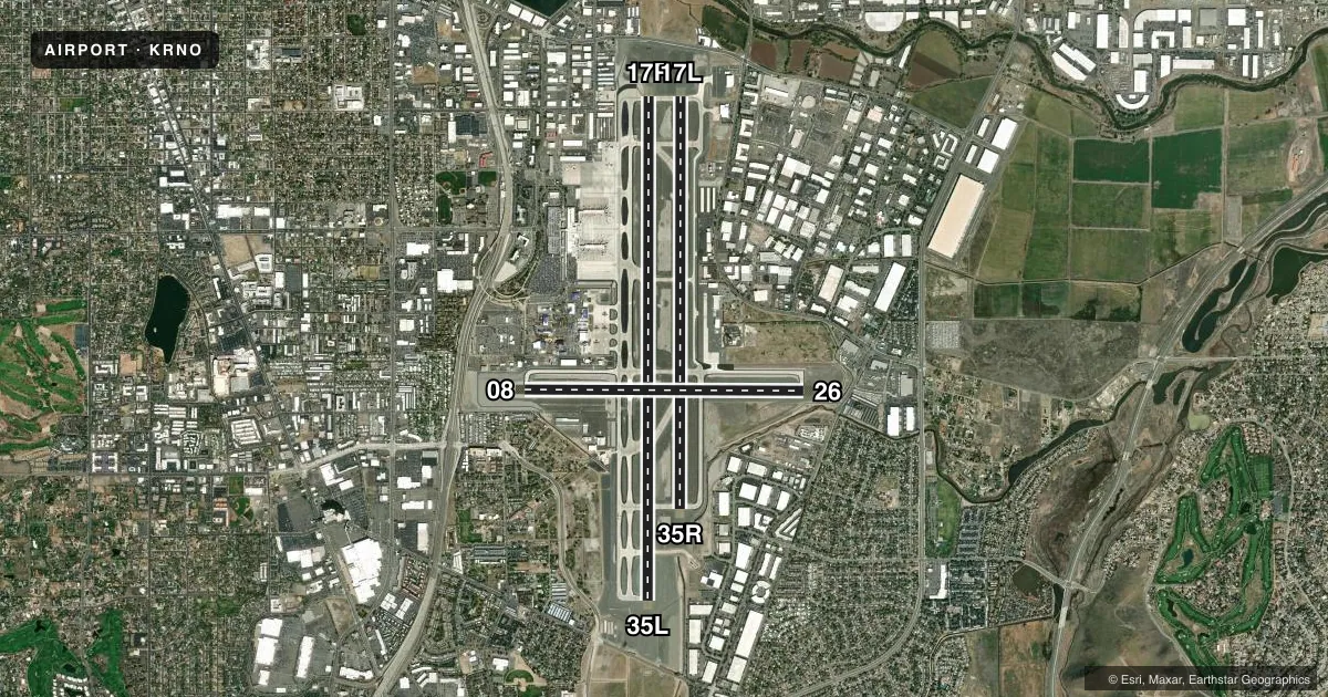
Runways & pattern
Full pagePattern entry · RWY 26
LEFT TRAFFIC| Runway | Heading (°M) | Length | Surface | Traffic |
|---|---|---|---|---|
| 17R/35L | 167° / 347° | 11,001 ft | CONC | Standard L |
| 17L/35R | 167° / 347° | 9,000 ft | CONC | Standard L |
| 08/26Favored | 77° / 257° | 6,102 ft | CONC | Standard L |
Runway end performance
| End | TORA | TODA | ASDA | LDA | VGSI | Approach lights | Obstruction |
|---|---|---|---|---|---|---|---|
| 17R | 11,001' | 11,001' | 11,001' | 10,001' | PAPI 4-box left(3.06°) | MALSR | — |
| 35L | 11,001' | 11,001' | 11,001' | 10,011' | PAPI 4-box left(3.54°) | MALSR | 243', gnd, 8050' from thr, 1500' R of cntrln, slope 32 |
| 17L | 9,000' | 9,000' | 9,000' | 9,000' | PAPI 4-box left(3°) | — | — |
| 35R | 9,000' | 9,000' | 9,000' | 9,000' | PAPI 4-box left(3.35°) | — | — |
| 08 | 5,854' | 5,854' | 6,102' | 5,854' | PAPI 4-box left(3.2°) | — | 118', pole, 2625' from thr, 500' R of cntrln, slope 20 |
| 26 | 6,102' | 6,102' | 6,102' | 6,102' | PAPI 4-box left(3°) | — | 44', tree, 1150' from thr, 275' R of cntrln, slope 21 |
Declared distances in feet. TORA = takeoff run available, TODA = takeoff distance, ASDA = accelerate-stop, LDA = landing distance.
Airport sketch
Runways drawn to scale from FAA survey coordinates, rendered over satellite imagery. Not for navigation.
Approaches & charts
ILS · 2
Services on the field
Fuel grades, oxygen, maintenance, ramp storage and lighting — as declared to the FAA by the airport operator.
Fuel & services
- Fuel
- 100LLA1+
- Oxygen (bottled)
- HIGH/LOW
- Oxygen (bulk)
- HIGH/LOW
- Airframe repair
- Major
- Power plant repair
- Major
- Other services
- AMB,AVNCS,CARGO,INSTR,RNTL,SALES
Ramp & ground
- Transient storage
- Tie-down
- Landing fee
- No fee published
- Customs
- Not available
- Lighting schedule
- SS-SR
- Beacon schedule
- SS-SR
- Beacon
- White / Green (civil land)(WG)
- Wind indicator
- Lighted
- Segmented circle
- No
Fuel & FBOs
Cheapest 100LL and Jet A on the field and nearby. Always confirm with the FBO before taxi.
Airport notes
Surface conditions, obstructions, local procedures, lighting outages and other notes published with each FAA cycle.
General notes
- WATERFOWL ALL QUADRANTS ALL SEASONS. CONCENTRATED NW OF RWY 17R AND EAST OF RWY 17L.
- 24 HRS PPR FOR TSNT ACFT PRKG WITH WINGSPANS GTR THAN 75 FT CALL 775-328-6600.
- TWY C BTN TWY L & TWY D RSTRD TO ACFT 100000 LBS OR LESS.
- NOISE SENSITIVE AREA ALL QUADS. PILOTS OF TBJT ACFT USE RCMDD NOISE ABATEMENT PROCS; AVBL ON REQ.
- NOISE NOTE CONT: PILOTS OF NON-TBJT ACFT USE BEST ABATEMENT PROCS AND SETTINGS. AVOID AS MUCH AS FEASIBLE FLYING OVER POPULATED AREAS.
- MIL ACFT: TSNT ACFT EXECUTE STRAIGHT-IN FULL STOP APCH. OVERHEAD PAT NOT AUTH FOR TSNT ACFT.
- MIL ACFT: NOISE ABTMT CRITICAL TERMINATE AFTERBURNER ASAP THEN CLIMB TO 6500 FT MSL ASAP.
- GLIDER/SOARING OPER 30-50 MILES SOUTH OF ARPT DURING VFR WEATHER & MOUNTAIN WAVE WIND CONDITIONS 1100 TO SS.
- TWY C BTN TWY L AND TWY D CLSD TO AIR CARRIER ACFT.
- TWY A BETWEEN NORTH TWY B AND TWY D CLSD TO ACFT WITH WINGSPAN GREATER THAN 149 FT.
- ALL COMMERCIAL AIRCRAFT CONTACT GROUND CONTROL FOR ADVISORIES PRIOR TO PUSH BACK ON THE TERMINAL RAMP.
- INTENSIVE GLIDER ACTIVITY INVOF ARPT AND SURROUNDING AREAS UP TO 18000 FT.
- ANG: PPR 24 HR PN RQRD.
- TWY M CLSD TO AIR CARRIER ACFT.
- TWY J EAST OF RWY 17L/35R CLSD TO AIR CARRIER ACFT.
- ANG: ANG OPS 1430-2359Z++ MON-FRI EXC HOL AND SKED DAYS OFF; OTR TIMES BY NOTAM; DSN 830-4709 OR C775-788-4709.
- ANG: APN HAS 22 FT X 6 FT ACFT GND EQUIP (AGE) BOXES LCTD TO THE EAST OF EA PKG SPOT.
- ACFT OVR 12500 LBS: WRITTEN PPR FOR TRG FLTS; FOR FTHR INFO CTC ARPT OPS 1-775-328-6600.
- ANG: COMSEC MTRL STORAGE AVBL WITH PRIOR CDN AT 152 CF/SCXS, DSN 830-4798.
- COLD TEMPERATURE AIRPORT. ALTITUDE CORRECTION REQUIRED AT OR BELOW -13C.
Runway surface & condition
- 08/26PCR VALUE: 787/R/C/W/T
- 17L/35RPCR VALUE: 1034/R/C/W/T
- 17R/35LPCR VALUE: 917/R/B/W/T
Approach & departure obstructions
- 35LAPCH RATIO 37:1 TO DTHR.
Other notes
- LDG RIGHTS ARPT, PPR - CALL (775) 784-5585; AFT HRS LDG WO PRIOR APVL NA.
- 800 FT AGL SNGL ENG; 1000 FT AGL MULT ENG/TURBOPROP/JET.
- MANAGERPRES/CEO OF RENO-TAHOE ARPT AUTH- CRIS JENSEN, ADAM TENNANT MGR OF AIRSDIE OPS 775-328-6490.
VFR map & nearby airports
VFR sectional. Tap any ICAO chip to open that airport.
Key facts · KRNO
Answer card- ICAO
- KRNO
- Name
- RENO/TAHOE INTL
- Location
- RENO, NEVADA
- Elevation
- 4,414.9 ft MSL
- Traffic pattern altitude
- 5,214.9 ft MSL (800 AGL)
- Control tower
- Towered · 24
- Total runways
- 3
- Longest runway
- 17R/35L · 11,001 ft
- Published ILS approaches
- 2
- Published frequencies
- 19
- Magnetic variation
- 13°
- Current flight rules
- VFR
- Current wind
- 280° at 3 kt
- Favored runway now
- RWY 26
Reno/Tahoe Intl sits in Reno, Nevada at 4,414.9 ft MSL. It has three concrete runways. The longest is 17R/35L at 11,001 ft. The tower is open 24 hours. Two ILS approaches are published for the 17R and 35L ends. Pattern altitude is 800 ft AGL for single-engine aircraft, which is 5,214.9 ft MSL. Multiengine, turboprop and jet traffic uses 1,000 ft AGL.
Atlantic Aviation is on the field. It carries 100LL and Jet A. Stellar Aviation of Reno is also on the field. It carries 100LL, Jet A and Jet A Prist. Reno is a noise-sensitive field in all quadrants. Turbojet crews should use the recommended noise abatement procedures on request. Non-turbojet pilots should use the best noise abatement settings they can. Avoid populated areas when practical.
This is a busy Class C airport with NORCAL approach frequencies in use. High elevation matters here. Expect performance planning to matter on departure and arrival. Glider and soaring activity can also be present south of the airport during VFR mountain-wave conditions from 1100 to sunset.